Water resources in the western United States are at a turning point. Droughts are becoming more common and as temperatures rise due to climate change more water will be needed to sustain the current landscape. The ongoing issues in the Klamath River Basin, a watershed crossing southern Oregon and northern California, are a case-study of how the West will handle future water scarcity. Aside from the limited supply of water, deciding how to manage this dwindling resource is no easy feat. Too much water has been promised to too many stakeholder groups, resulting in interpersonal conflict, distrust, and litigation. Our guest this week is Hannah Whitley, a PhD Candidate of Rural Sociology at Pennsylvania State University and a Visiting Scholar in the School of Public Policy at Oregon State University. Hannah grew up on a beef ranch in a small southwestern Oregon town, so she knows some of these issues all too well. Hannah is investigating how governance organizations work together to allocate water in the Upper Klamath Basin and how to tell the story of what water means to different stakeholder groups. By observing countless hours of public meetings, having one-on-one conversations with community members, and incorporating a novel research method called photovoice, she hopes to understand what can make water governance processes successful because the current situation is untenable for everyone involved.

How we got here
Prior to the 1800s-era Manifest Destiny movement, the area known today as the Upper Klamath Basin was solely inhabited by the Klamath Tribes (including the Klamath, Modoc, and Yahooskin-Paiute people). At the time, Upper Klamath Lake was at least four times its original size, and c’waam (Lost River suckers) and koptu (shortnose suckers) thrived in abundance. The 1864 Klamath Treaty, ratified in 1870, officially recognized the Klamath Tribes as sovereigns in the eyes of the federal government. Treaties are especially powerful arrangements with the federal government, akin to international agreements between nations. These agreements are generally considered to be permanent laws, or at least that’s what the tribes were told.
As part of the conditions of the Klamath Tribes Treaty, tribes retained hunting, fishing, and water rights on 1.5 million acres of land, but ceded control of 22 million acres to the federal government. Those expropriated lands were given to westward settlers who took advantage of 1862 Homestead Act. The 1906 Reclamation Project drained much of Upper Klamath Lake, leaving behind soils that are nutrient dense and thus highly valuable. An additional homesteading program associated with the 1902 Reclamation Act prioritized the allocation of reclaimed federal land to veterans following World War I (there is ongoing litigation on whether these settlers have water rights as well, or just land rights). These land deeds have been passed onto families over time, though many mid-twentieth-century homesteaders opted to sell their land during the 1980 Farm Crisis.
The Klamath Tribes’ unceded lands were not contested during the intervening years. In the mid-1950s, however, the U.S. government used the 1954 Termination Act to nullify the Klamath Tribes’ 1864 Treaty. Although the Klamath tribes were “one of the strongest and wealthiest tribal nations in the US,” one result was the loss of the tribes’ remaining land and management rights. In 1986, their status as a federally-recognized tribe was restored, however, no land was returned. Soon after the Klamath Tribes were federally recognized (again), two species of fish that only spawn in the Upper Klamath Lake area were listed as endangered species. This provided both the c’waam and koptu fish species new legal protections, though they have always had significant cultural significance for the Klamath Tribes.
Where are we now
The Klamath River Basin is said to be one of the most complicated areas in the world due to the watershed’s transboundary location and the more than 60 different parties who have some interest in the Basin’s water allocation, including federal agencies, the states of California and Oregon, counties, irrigation districts, small farmers, large farmers, ranchers, and tribal communities. The Klamath Tribes play an active role in the management of water Basin-wide, although final governance decisions are made by state and federal agencies including the Bureau of Reclamation, Fish and Wildlife Service, and state departments of environmental quality.
Currently, the Upper Klamath Basin is occupied by multi-generation farmers and ranchers on lands that are exceedingly favorable for agricultural production. Some families have accumulated significant portions of land since the 1900s while others are still small-acreage farmers. As a result of farm consolidations that resulted from economic distress during the twentieth-century, many families had overwhelming success in purchasing adjacent and nearby land parcels as they were sold over the last hundred years. The result is that these few well-resourced families have disproportionate control of the area’s agricultural and natural resources compared to smaller-scale farms.
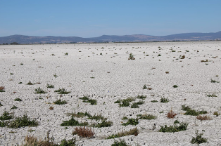
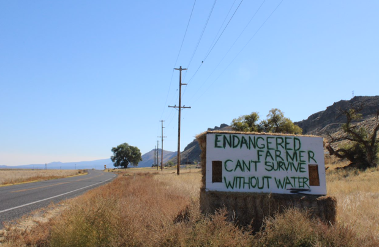
There are a variety of crops under production such as potatoes for Frito-Lay, Kettle Foods and In-N-Out Burger, as well as peppermint for European teas, and alfalfa used to feed cattle in China and the Willamette Valley. Regardless of the crop, as temperatures have risen and drought conditions worsen, Basin farmers and ranchers need more water each and every season. And it’s typically the more established farms who have a bigger say in how Upper Basin water (or lack thereof) and drought support programs are managed, regularly leaving smaller farms frustrated with decision-making processes. In addition to the seasonal droughts keeping lake levels low, stagnant water, summer sunshine, and nutrient runoff contribute to algae proliferation in the Upper Basin that decreases the survival rate of the endangered fish. Unfortunately, there is simply not enough water to continue with the status quo.
How are we moving forward
How do you balance all* of these competing interests through a collaborative governance model? (*We haven’t even mentioned the dams, or the downstream Yurok and Karuk tribes relying on water for salmon populations, the Ammon Bundy connection, or the State of Jefferson connection, read the multi-part series in The Herald for a deeper dive.) There needs to be a process where everyone is able to contribute and understand how these decisions will be made so they will be accepted in the future. Unfortunately, little research has been done in this area even though the need for new climate adaptation policies are increasingly in demand.
This is ongoing work that Hannah Whitley is conducting for her dissertation; how are stakeholders engaged in water governance? What are the different effects of these processes on factors like interpersonal trust, perceptions of power, and participation in state-led programs? The theory of the case is that if everyone’s voice is heard, and their concerns are addressed as best they can given limited resources, the final agreement may not completely satisfy all parties, but it’s an arrangement that is workable across all stakeholders.
Hannah has been conducting field work since September that includes observing public meetings, interviewing stakeholders, and diving into archives. Hannah attended an in-person farm tour in September. During lunch, one Upper Basin stakeholder inquired about the feasibility of conducting a photovoice project similar to what Hannah did for her Masters thesis work with a group of women farmers and gardeners in Pittsburgh, Pennsylvania. The photovoice project allows individuals to tell their own stories through provided cameras with further input through collaborative focus groups. We will talk about this and so much more. Be sure to listen live on Sunday January 23rd at 7PM on 88.7FM or download the podcast if you missed it! Follow along with Hannah’s fieldwork on Instagram at @myrsocdissertation or visit her website.
This post was written by Adrian Gallo and edited by Hannah Whitely
