
Blog by Meghan King, PhD student, Oregon State University College of Earth, Ocean, and Atmospheric Sciences

Growing up on the north shore of Long Island, it was inevitable that my life would be shaped by water and sediment. As a child I wandered the rocky beach near my house with my magnifying glass for hours on end, examining everything from sand grains to boulders. In the fourth grade I learned how my little island came to be: a product of repeated glacial advances and retreats that created terminal moraines and outwash plains. At nine years old I became obsessed with understanding Earth’s history through sedimentary deposits, so it’s no surprise that I ended up at Oregon State for a Ph.D. in the field of stratigraphy!
Stratigraphy: it’s all about the layers
Stratigraphy is a branch of geology that studies the order of layered sedimentary rocks (strata) and their relationship to each other and the geologic time scale. Stratigraphy is fascinating because it is essentially an archive of Earth’s history at a specific geographic location. Some more well-known examples are the Grand Canyon and Death Valley, both of which were covered by an ancient shallow sea during the Paleozoic (542-251 Ma). The strata were originally deposited horizontally within that shallow sea and are different from each other in color, composition, grain size, etc.
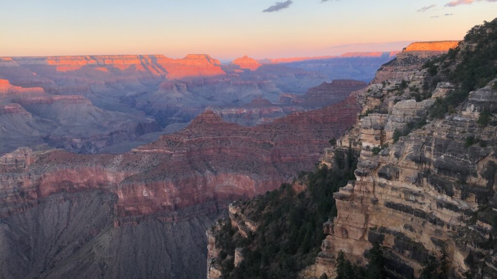

My love of water, sediment, and large changes in Earth’s climate converge in my Ph.D. research. The strata in shallow marine environments (like those pictured) physically record how sea level fluctuated in response to glacial-interglacial periods. This is because sea level alters the type and characteristics of deposited sediments. Sea-level response to ice sheet change is typically thought of in the form of a “bathtub” model: When ice starts to melt, the water in the ocean will rise uniformly everywhere like a bathtub. However, this isn’t the whole picture of global sea level.
As ice sheets grow during a glacial period, they push down on the crust beneath them and create a raised bulge around the periphery, just like sitting on a mattress. The opposite happens during the intervals between ice ages. This concept is called glacial isostatic adjustment (GIA). GIA causes sea level to vary at different points on the Earth such that sea level doesn’t change at the same rate/magnitude everywhere. A few other processes contribute to this phenomenon as well. For example, ice sheets are large enough that they exert a gravitational pull on the oceans and draw water towards them, causing sea level to be higher near the ice sheets!
modeling, but for the rocks
What I’m most interested in for my Ph.D. is how GIA alters the stratigraphic preservation of glacial-interglacial cycles. Is there a geographic pattern to this alteration? If so, can we disentangle the signal of GIA from the rest of the stratigraphic record? While we have other records of glacial-interglacial cycles, they tend to exist for only a portion of recent Earth history, so for older deposits, stratigraphy offers consistent insight.
How have I approached this problem? Modeling! The rich history of field and lab work in the geosciences tends to get a lot of the attention (a lot of cool examples in previous blog posts though), but recently models have become an equally important tool! Modeling may not be as exciting to some, but it’s really fascinating to think about all the questions we can begin to answer with just a few – or in my case – a lot of lines of code!
Over the past three years I’ve developed some programs in MATLAB which allow me to combine sea level histories and sedimentation histories to build projected stratigraphic records from scratch. The output ends up looking something like the pictures above. I can then correlate, or compare, these records across space to help us understand how GIA is affecting the preservation of glacial-interglacial signals inputted into the models.
I’ve already completed a project using these models on Quaternary (2.6 Ma – present) glacial-interglacial cycles for the West Coast, and now I’m working on expanding the project in a variety of directions. I’ll be incorporating other inputs to make the models more robust. For example, I can vary the model’s ice histories, earth models and tectonic histories, and apply the model to more globally distributed locations in the Pliocene (5.3 – 2.6 Ma).
There is more to understand about sea-level change in the face of our warming climate, so I hope that these models can be altered and applied to a range of other projects as well. Maybe the next generation of inquisitive nine-year-olds hold the key?