Out of the Office and Into the Islands (Or, That Time When I Was Still Allowed to Travel)

This blog is a bit of a throw-back, but an experience I’ve been meaning to document here for some time. Before COVID-19, during the week of September 30th to October 4th, 2019, I had the opportunity to join representatives from the West Coast Ocean Tribal Caucus, my supervisors from the West Coast Ocean Alliance (WCOA) and West Coast Ocean Data Portal (WCODP), and facilitators from the Udall Foundation on an exchange trip to British Columbia and First Nations territories.

The purpose of the trip was for Tribes and First Nations with territories along the West Coast of the United States and Canada to exchange ideas and experiences related to ocean management and planning, especially as they relate to coordination with state, federal and provincial governments. The exchange was hosted by the Marine Plan Partnership for the North Pacific Coast (MaPP), which is a collaborative entity for marine planning between First Nations governments and the British Columbia provincial government.

Our first full day in British Columbia was spent in Vancouver, on the unceded territory of the Musqueam, Squamish, and Tsleil-Waututh First Nations (most First Nations in British Columbia never ceded any of their land through treaties with the Canadian or British government). After an opening prayer and introductions, this day focused on identifying benefits of and methods for collaborating on ocean planning with other indigenous governments, stakeholders, and state, federal, and provincial partners. Presentations and panels included representation from the WCOA, WCODP, MaPP, the Nanwakolas Council, the Central Coast Indigenous Resources Alliance (CCIRA), the Coastal First Nations – Great Bear Initiative, and several Tribes, First Nations, and provincial and state governments.

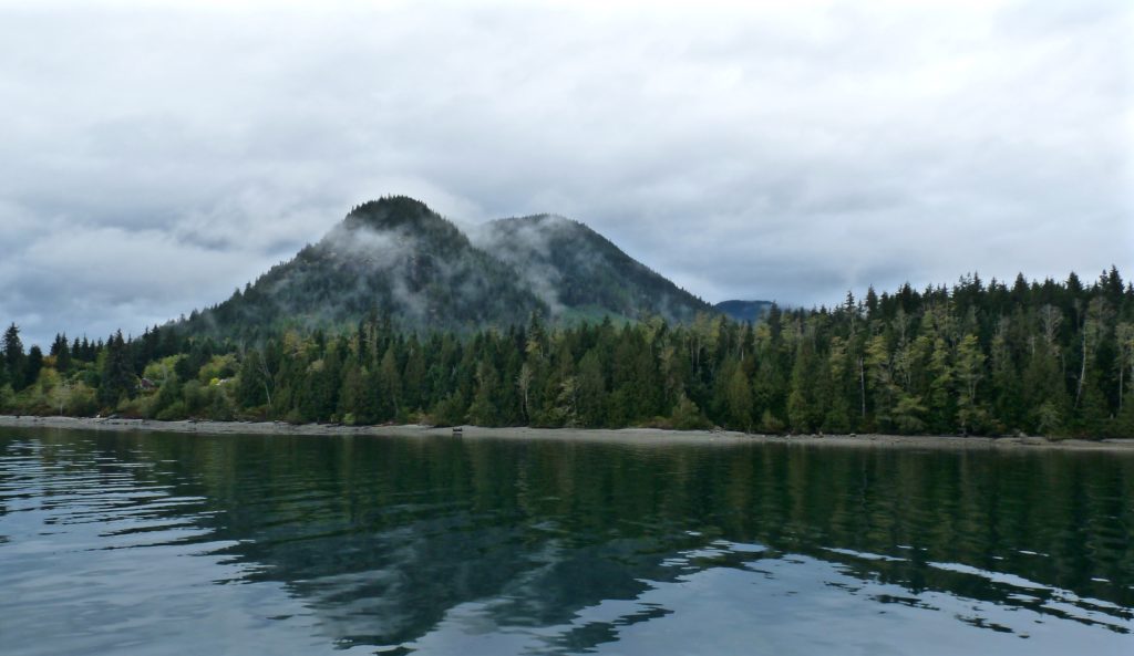
While our first day in Vancouver offered a compelling discussion and exchange of information, the highlight of the trip was undoubtedly our visit further north, where we spent time in the town of Campbell River on Vancouver Island— and about 12 hours on the water exploring First Nations territories in the Central Coast Region.  

We flew to Campbell River on our second day in British Columbia, and after some additional presentations and a night of fresh seafood (Halibut! Prawns! Salmon! Clams! Crab!) and dancing as guests of the Wei Wai Kum First Nation, we departed on the boat trip early in the morning under the cover of classic Northwest clouds. The overarching purpose of this on-the-water trip was to share examples of different indigenous ocean planning projects on the Central Coast, and in particular to highlight the Indigenous Guardians Program— a program where indigenous ‘Guardians’ are employed in their territories to do ecological monitoring and protect cultural resources, and contribute to land and marine-use planning. We had a lot of stops to fit in, so while you can view our entire itinerary on the map below, I’ll just offer a few highlights in this blog.

Visiting this many places in one day meant we had a fast boat and a schedule to stick to— even when we saw orcas, we could only slow down to watch them for a brief amount of time!
Cruising along the Central Coast of Vancouver Island.
Our trusty vessel for the day.
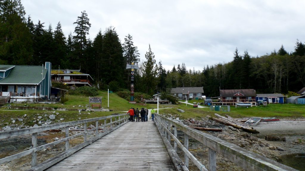
  • Tsatsisnukwomi (not pictured on map): This is a village site of the Da’naxda’xw-Awaetlala First Nation, where we ate lunch. This village was actually abandoned in the 1960s, after many children were relocated because of the devastating Canadian Indian residential school system, and the lack of other teaching and healthcare resources made the isolation of the area untenable. However, in the early 2000s, several people worked hard to make the village habitable again, and a new Bighouse was unveiled in 2004. We were able to visit the inside of this Bighouse and hear stories about the village and Da’naxda’xw-Awaetlala people from the Guardian onsite.
Headed to lunch in Tsatsisnukwomi.
Totem outside the Bighouse in Tsatsisnukwomi.
  • Port Neville: This area was identified by the Tlowitsis First Nation as a special management zone, where Guardians are currently monitoring temperature and salinity as they conduct scallop aquaculture experiments. The Tlowitsis and other First Nations in this area are aware that increased mariculture is likely coming to the region—so why shouldn’t they be the first ones to derive that economic benefit? However, issues like transporting the scallops to markets for sale and seed security are issues that will need to be overcome before this becomes a full commercial enterprise.
Approaching the scallop pilot project area in Port Neville.
I think this scallop is the biggest one I’ve ever seen— and apparently, they can’t be eaten because they are part of an experimental trial! (photo credit: Andy Lanier)
  • Compton Island, Village Island, and Kalogwis: These stops were all part of the Arch Pilot Project, a partnership between MaPP, the Nanwakolas Council and the province of British Columbia on Tlowitsis and Mamalilikulla First Nations territories. While the Provincial Heritage Conservation Act of British Columbia is supposed to protect archeological sites like those found in these areas, Elders had been concerned for decades that it was not working – and they were right. A sailor and kayaker myself, I love exploring lesser known inlets and waterways, and I was upset to hear of the way that coastal cruisers had passed on the location of these sacred spaces over the years, unearthed archeological sites, and taken artifacts and even bones for themselves as souvenirs. The goal of this pilot project is to increase protection over and improve public knowledge of the importance of these cultural resources, and to demonstrate the effectiveness of the Guardians program in stewarding these places and resources.
An old village site and shell midden within the Arch Pilot Project area.
Petroglyphs within the Arch Pilot Project area.
The day wouldn’t have been complete without spotting some gray whales on our way home! (photo credit: Andy Lanier)

After our long day on the water concluded, we had a closing dinner in Port McNeill and a three-hour bus drive back to Campbell River. The next day, it was time to head back to Vancouver and then to Oregon. Altogether, this trip was a highlight not just of my fellowship, but of my early career thus far. Not only did this trip introduce management and planning approaches that our Tribal Caucus and state and federal partners can bring back to their work in U.S., but it gave me a front row seat to what collaboration between these different entities can achieve, and that is an example that I know will stay with me. All of the participants on this trip were so pleased with the outcomes that before it ended, we were talking about continuing the exchange in the future. We hope that next time, we can host our colleagues from British Columbia and First Nations on the other side of the international border.

This exchange was funded by the Marine Conservation Initiative of the Gordon and Betty Moore Foundation. A detailed summary of the exchange, as well as a related guide for state and federal agencies working with West Coast tribes on ocean and coastal issues, will be publicly available via the West Coast Ocean Alliance later this year.

Creating a Scorecard for West Coast Ocean Health

In summer 2019, at the request of West Coast Ocean Alliance (WCOA) members, the West Coast Ocean Data Portal (WCODP) began preliminary work on the creation of a West Coast Ocean Health Scorecard. The WCODP had been seeking direction on data activities from the WCOA for some time, and this project offered a way to focus the efforts of WCODP, and complement similar efforts being undertaken by the states of Washington and California. A primary goal for this scorecard effort is to define standards and critical thresholds concerning priority ocean health issues across the region, and to present a cohesive picture of what West Coast ocean health looks like to the public.

For the first several months of this project, I spent time reviewing existing ocean health tools, including scorecard products and frameworks. Examples I looked at include the Ocean Health Index, NOAA’s Integrated Ecosystem Assessment, and the Condition Reports of National Marine Sanctuaries. I wanted to see how other groups had organized indicators and tackled some of the challenges inherent to a project of this scale, e.g., how goals and baselines were agreed upon and how results were presented clearly to different audiences.

After looking at what different examples had to offer, I set to work on creating a framework for what the WCODP scorecard could look like. With the help of my supervisors, the co-chairs of the WCODP, I created a nested framework of about 15 indicators that fit into three larger topics: stressors, ecosystem health, and human use. During this process, I received regular input on monthly WCODP Coordination calls, and in December of 2019, I presented our framework and ideas for a scorecard tool at a full-day data workshop, as part of the larger WCOA Annual Meeting.

While WCOA members had feedback on the goals, audience, and organization of the scorecard, they were in general agreement of moving forward on the project. It was decided that with initial funding from the NOAA Regional Data Sharing Initiative, we would move forward with three ‘proof of concept’ indicators for development in 2020. The indicators decided upon were beach water quality, ocean acidification, and kelp.

Unfortunately, COVID-19 has delayed some of this indicator work in 2020, but we do have three concurrent efforts going on for which I’ve been able to help with scopes of work, grant management, and contracts as well as research. Heal the Bay, a California-based nonprofit, is leading the work on a beach water quality indicator, and NANOOS (Northwest Association of Networked Ocean Observing Systems), in cooperation with the other West Coast IOOS (Integrated Ocean Observing System) Regional Associations, is leading work on the ocean acidification indicator. I am currently leading work on the kelp indicator, and have spent the last few months researching different methods for examining canopy-forming kelps’ extent, persistence and quality— including remote-sensing, aerial overflight surveys and in-water surveys. In the next few weeks, the WCODP will begin a comparison study of these methods on specific giant kelp beds in Southern California, in order to inform our scorecard effort.

Altogether, the West Coast Ocean Health Scorecard will be a three to five year effort before its first iteration is complete. In the next few years, we are hoping to continue developing the framework and user interface for the public to interact with the scorecard, and to continue developing individual indicators. I am currently planning to stay involved with the project once my fellowship has ended, and have learned a lot from seeing how a longer-term venture like this develops and evolves from the beginning. Here’s to hoping for a successful project, and a healthy West Coast ocean!

Planning for the Possibility of Offshore Wind on Oregon’s Outer Continental Shelf

One of the most interesting things about my fellowship is that while I technically work for the West Coast Ocean Alliance (WCOA) and West Coast Ocean Data Portal (WCODP), my duties require that I interact frequently with staff from federal agencies, state governments, and tribal governments, and liaise with them on specific projects. One project that I am working on at the moment is the development of an Oregon Offshore Wind Planner tool for the State of Oregon and Bureau of Ocean and Energy Management (BOEM), which is being hosted by the WCODP.

BOEM is the federal agency responsible for for issuing leases for renewable energy projects on the Outer Continental Shelf (OCS), and they have a Renewable Energy Authorization Process that they engage in before any decisions about leases are made in an area. BOEM must coordinate with governmental partners for this process, and the primary way that they do so is through Intergovernmental Renewable Energy Task Forces. These Task Forces consist of federal agencies, state governments, local governments and federally recognized tribes; there are currently fourteen Task Forces in the United States. While Oregon held its first Task Force meeting in 2011, they paused meetings for several years until September 2019. At this meeting, BOEM and the State of Oregon announced their intention to begin an offshore wind planning process, which could take 5 – 10 years and eventually culminate in the construction of offshore wind operations off the coast of Oregon— or, depending on the input from state, local, and tribal governments, and stakeholders— nothing at all. Since it is an effort that is ultimately about building trust amongst all of these groups, the beginning of this process involves a lot of planning and analysis— and the collection of lots of data and input from interested parties and stakeholders.

The first offshore wind farm in the United States off of Block Island, Rhode Island. We may have similar sights here in Oregon in the future, but not until after several years of planning and collecting input from different government entities and stakeholders (Image from Ørsted and Rhode Island Sea Grant).

In order to publicize and receive feedback on their strategy to gather and analyze data, the Task Force produced a Draft Data Gathering and Engagement Plan, which they presented at a remote Task Force meeting in June 2020 and received comments on for several weeks afterward. In this plan, the Task Force outlines their intention to use the West Coast Ocean Data Portal as a platform to house a map-viewer tool that highlights all the data to be used in the planning process, and that could lead to the eventual selection of what are called ‘Call Areas.’ The term Call Areas comes from the publication in the Federal Register of a ‘Call for Information and Nominations,’ which means that BOEM wants more information from researchers and stakeholders about that area, and nominations from developers saying that they would be interested in bidding on a lease there. In other words, they are specific geographic areas that will undergo further review to see if BOEM will accept competitive bids for leases there at the appropriate time in the future.

The working title for this tool is the Oregon Offshore Wind Planner, and this is where I come into the picture. I have been working with staff from the State of Oregon and BOEM to identify the datasets we want to include in this tool, and to make sure that we have the most up-to-date data as possible. Sometimes, this requires a bit of sleuthing, and in one case the data we were looking for seemed to have been lost in a fire where a server was destroyed. Fortunately, we tracked it down somewhere else!

A screenshot of the not-yet-released Oregon Offshore Wind Planner tool, with some example layers turned on.

Some of the places we’re looking include ERDDAP (a data access program belonging to NOAA), Marine Cadastre (A joint BOEM and NOAA initiative providing data to meet the needs of offshore energy and marine planning communities) and the Oregon Spatial Data Library (a joint effort between the Department of Administrative Services Geospatial Enterprise Office and Oregon State University). We’re also reviewing existing BOEM-funded reports on the West Coast to make sure we capture any relevant spatial data that comes from them.

Right now, the plan is to conclude this initial data-gathering process and release the draft version of the Oregon Offshore Wind planner tool this fall. At that point, BOEM and the State of Oregon will collect feedback from affected parties and stakeholders about whether they have all the data they should in order to inform the larger process that could lead to the creation of Call Areas off the coast of Oregon. This whole process is one that I was generally aware of, but never involved with prior to my fellowship— now, I’ve learned a lot about data management, made some interesting connections in the hunt for spatial data, and am looking forward to tracking this process long-term. For more information on renewable energy activities and future public meeting announcements for the Task Force, you can visit boem.gov/Oregon.


Regional Coordination During COVID-19

Since the advent of the COVID-19 pandemic this Spring, many of our professional and personal lives have changed dramatically. If we are lucky enough to still be employed and healthy, those of us in the policy realm are likely working from home, somewhat settled in a new ‘normal,’ and wondering just how long we are going to be feeling the impacts of COVID-19.

My position as a fellow has always been remote, because working with the West Coast Ocean Alliance (WCOA) and West Coast Ocean Data Portal (WCODP) entails working with (and finding creative ways to communicate with) state, tribal, and federal government agencies along the West Coast of the U.S. In other words, I used Zoom before it was cool— so the past few months haven’t been terribly different for me (unless you count the pervasive sense of doom).

However, many of our WCOA members are busy overseeing changes to the way their agency regularly operates, responding to COVID-19 related issues in their region, and planning for impacts that will extend well into the future. While the capacity of these members to engage in regional discussions with the WCOA and WCODP has not been too diminished, there are a few distinct ways that the pandemic has affected our member entities and the work of the WCOA, and will continue to do so moving forward.

Shifting Focus

When coronavirus cases began to climb in the U.S. and West Coast states issued stay-at-home orders, many of our WCOA members had to spend time equipping their employees to telework and assessing the risks of continuing field work and shipboard programs. For example, several research cruises that were scheduled for this year and that contribute to long-term monitoring efforts on the West Coast have been suspended, and in March NOAA Fisheries issued an emergency action to waive observer coverage on fishing vessels on a case-by-case basis, which is still in place. For some of the WCOA’s tribal members, such as the Quinalt Indian Nation, decisions were made to close tribal land to all visitors until deemed safe to reopen.

All of the time and effort needed to respond to the challenges presented by COVID-19 necessarily took time away from individuals’ ability to engage in specific regional projects, and despite the fact that connecting on remote platforms was not new to us, the advent of COVID-19 led to a lot of confusion and frequently changing policies about which platforms different members were allowed to use! However, the regular meetings of the WCOA during this time have provided an excellent forum for comparing impacts and responses to coronavirus across the region, sharing updates about changes that could affect other member entities, and providing reassurance that this has been a difficult time for everyone to adapt to.

Shifting Finances

Our state and tribal partners rely on diverse sources of revenue to fund their governments, including tourism, commercial fishing, and annual fees for activities like recreation access. All of these activities and the funds they provide have been curtailed significantly this year, and many of our members are facing budget deficits, hiring freezes and furloughs in their entities. Washington State is expecting an $8.8 billion budget deficit through 2023, and Governor Jay Inslee recently announced that he would be requiring mandatory furlough days for state agencies at least through this fall. California recently had a hotly contested budget debate, and Oregon may still hold a second special session for state legislators later this summer, to deal with the economic impacts of coronavirus to the state.

The WCOA and WCODP do not rely on financial contributions from member states and tribal governments in order to operate, but instead have multiple different funding streams from federal and foundation sources. In this way, funding for the WCOA and WCODP will not be directly affected by coronavirus for the near future. However, fewer resources and staff for our members will impact the capacity they have to continue with our regional efforts, and some federal agencies and private foundations are likely to have less money to distribute and / or more applicants for opportunities in the future.

Looking Ahead to New Methods of Coordination

The WCOA and WCODP use their funding streams to pursue a variety of projects according to the needs and preferences of their members. As we face the reality that out-of-state travel and meetings may be severely limited for at least the next couple of years, we have been thinking about how we may need to prioritize some projects over others and how we might adapt some of our regular practices based on this changing landscape.

For example, the WCOA and WCODP have long been considering a spatially-enabled database tool to facilitate communication and identify key contacts as they relate to ocean and coastal projects developing on the West Coast. Now that the COVID-19 pandemic has eliminated many opportunities for in-person communication on this subject, the WCODP plans to push the development of this tool throughout the rest of 2020.

The WCOA and WCODP also strive to hold an in-person meeting for their members annually, rotating between the three West Coast states of Washington, Oregon, and California. With a 2019 meeting in Tacoma, WA under my belt, I was looking forward to planning an engaging event in Oregon this year. However, like many large meetings and conferences slated for 2020, we are now brainstorming ways to host a productive remote gathering at the end of this year.

Since beginning my fellowship last June, a sentiment that I have heard over and over again from WCOA and WCODP members is that the true value of a regional coordinating group like the West Coast Ocean Alliance is found in the personal relationships it creates. These relationships lead to information-sharing and collaboration on research and policy, and can contribute to conflict resolution when some entities don’t see eye-to-eye. Our members may not meet up in person this year as often as they have in the past, but I am certain that these relationships and their value will endure. Perhaps, moving forward, regional coordination will become even more important in order to leverage resources for positive outcomes for our coasts and oceans. As a coordinating body, the WCOA will continue to remain flexible, react to the needs of our members, and see where the next several months take us.

Supporting Collaboration and Data Accessibility on the West Coast of the U.S.

Less than one month ago, I began my Oregon Sea Grant Fellowship supporting the West Coast Ocean Alliance (WCOA) and West Coast Ocean Data Portal (WCODP). Since beginning, I have spent a considerable amount of time familiarizing myself with the history and composition of these unique entities.


The West Coast Ocean Alliance is a regional partnership that focuses on “enhanced management and coordination for the ocean along the West Coast of the U.S” (WCOA). It is made up of state, tribal, and federal representatives, and currently has four objectives: compatible and sustainable ocean uses, effective and transparent decision making, comprehensive ocean and coastal data, and increased understanding of and respect for tribal rights, traditional knowledge, resources and practices.

The current Alliance is part of a broader legacy of regional ocean coordination on the West Coast. In 2007, the governors of California, Oregon, and Washington created the West Coast Governors Agreement on Ocean Health. Focusing on topics like marine debris and coastal resilience, the West Coast Governors Agreement also prioritized data coordination and the creation of the West Coast Ocean Data Portal. In 2010, with Executive Order 13547, President Obama created our country’s first National Ocean Policy. This policy introduced a mechanism for creating Regional Planning Bodies (RPBs) that formalized federal engagement in regional ocean planning processes. The West Coast states and tribal governments began discussing the creation of an RPB in 2013, and in 2016 signed their formal charter. Concurrently, the West Coast Governors Agreement on Ocean Health evolved into the West Coast Governors Alliance on Ocean Health, a Regional West Coast Ocean Partnership that could work with the RPB. Finally, in June 2018, President Trump’s Executive Order 13840 replaced Obama’s National Ocean Policy, and terminated the active RPBs in the U.S. Official regional coordination could, however, continue through Regional Ocean Partnerships, and so the participants of the West Coast RPB and the West Coast Ocean Partnership elected to continue their coordination as the West Coast Ocean Alliance in late 2018.

This all sounds pretty complicated—so why bother with regional ocean coordination? Ecosystem functions and species, as well as ocean issues like pollution, do not respect jurisdictional boundaries. Therefore, state, tribal and federal decision-makers frequently need to work together on problem-solving and management decisions. Habitat loss in one state’s waters might inform management of a migratory species in another’s. Energy development in federal waters could affect multiple state and tribal fishing industries. So realistically, if we want to be effective coastal and ocean managers, we can’t afford not to coordinate on a regional scale—especially as the marine environment faces unprecedented changes and development pressure.

Check out all the different activities that can take place near one small part of the coast! (Image: NACo)

A huge part of that coordination is information sharing. It is important to ensure that regional discussions and decision-making are based on sound science and the most current data, which is where the West Coast Ocean Data Portal comes in. The WCODP is meant to be a one-stop-shop for state and tribal coastal and ocean managers, who are seeking to inform their decisions with relevant data and visualizations. Part of my Fellowship will be engaging with WCODP and WCOA members over the next year to determine the types of data that will be truly useful to different entities, the format in which they would like to see that data, and how we can set up long-term relationships to keep that data up-to-date. Below, see an example from the Data Portal that displays offshore wind resource potential on the West Coast.

The WCODP can help decision-makers who are siting Marine Renewable Energy (MRE) projects like floating wind turbines on the West Coast by summarizing and presenting relevant data in one location, and connecting managers, regulators, scientists and stakeholders.  (Image: WCODP)

I have already experienced my first WCOA member call, which included over 50 representatives speaking on behalf of different governing bodies with distinct interests and priorities. It is clear that high levels of organization and coordination are required to keep a group like this focused on a unified vision and specific objectives, and helping move the Alliance toward longer-term goals will be another important task of mine in the coming months.

It may be a challenging time for our oceans, but it is also an exciting one, as decision-makers explore innovative solutions and cooperate on regional scales to build a unified vision for our coastlines. I am grateful for the opportunity to be a part of this conversation on the West Coast, with so many motivated partners. Stay tuned for an update on how my position is going this December!