
One of the most interesting things about my fellowship is that while I technically work for the West Coast Ocean Alliance (WCOA) and West Coast Ocean Data Portal (WCODP), my duties require that I interact frequently with staff from federal agencies, state governments, and tribal governments, and liaise with them on specific projects. One project that I am working on at the moment is the development of an Oregon Offshore Wind Planner tool for the State of Oregon and Bureau of Ocean and Energy Management (BOEM), which is being hosted by the WCODP.
BOEM is the federal agency responsible for for issuing leases for renewable energy projects on the Outer Continental Shelf (OCS), and they have a Renewable Energy Authorization Process that they engage in before any decisions about leases are made in an area. BOEM must coordinate with governmental partners for this process, and the primary way that they do so is through Intergovernmental Renewable Energy Task Forces. These Task Forces consist of federal agencies, state governments, local governments and federally recognized tribes; there are currently fourteen Task Forces in the United States. While Oregon held its first Task Force meeting in 2011, they paused meetings for several years until September 2019. At this meeting, BOEM and the State of Oregon announced their intention to begin an offshore wind planning process, which could take 5 – 10 years and eventually culminate in the construction of offshore wind operations off the coast of Oregon— or, depending on the input from state, local, and tribal governments, and stakeholders— nothing at all. Since it is an effort that is ultimately about building trust amongst all of these groups, the beginning of this process involves a lot of planning and analysis— and the collection of lots of data and input from interested parties and stakeholders.

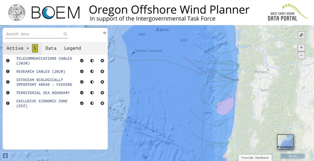
In order to publicize and receive feedback on their strategy to gather and analyze data, the Task Force produced a Draft Data Gathering and Engagement Plan, which they presented at a remote Task Force meeting in June 2020 and received comments on for several weeks afterward. In this plan, the Task Force outlines their intention to use the West Coast Ocean Data Portal as a platform to house a map-viewer tool that highlights all the data to be used in the planning process, and that could lead to the eventual selection of what are called ‘Call Areas.’ The term Call Areas comes from the publication in the Federal Register of a ‘Call for Information and Nominations,’ which means that BOEM wants more information from researchers and stakeholders about that area, and nominations from developers saying that they would be interested in bidding on a lease there. In other words, they are specific geographic areas that will undergo further review to see if BOEM will accept competitive bids for leases there at the appropriate time in the future.
The working title for this tool is the Oregon Offshore Wind Planner, and this is where I come into the picture. I have been working with staff from the State of Oregon and BOEM to identify the datasets we want to include in this tool, and to make sure that we have the most up-to-date data as possible. Sometimes, this requires a bit of sleuthing, and in one case the data we were looking for seemed to have been lost in a fire where a server was destroyed. Fortunately, we tracked it down somewhere else!
Some of the places we’re looking include ERDDAP (a data access program belonging to NOAA), Marine Cadastre (A joint BOEM and NOAA initiative providing data to meet the needs of offshore energy and marine planning communities) and the Oregon Spatial Data Library (a joint effort between the Department of Administrative Services Geospatial Enterprise Office and Oregon State University). We’re also reviewing existing BOEM-funded reports on the West Coast to make sure we capture any relevant spatial data that comes from them.
Right now, the plan is to conclude this initial data-gathering process and release the draft version of the Oregon Offshore Wind planner tool this fall. At that point, BOEM and the State of Oregon will collect feedback from affected parties and stakeholders about whether they have all the data they should in order to inform the larger process that could lead to the creation of Call Areas off the coast of Oregon. This whole process is one that I was generally aware of, but never involved with prior to my fellowship— now, I’ve learned a lot about data management, made some interesting connections in the hunt for spatial data, and am looking forward to tracking this process long-term. For more information on renewable energy activities and future public meeting announcements for the Task Force, you can visit boem.gov/Oregon.
Hi Marisa, Thanks for this post and the reminder about the importance of thoughtful data management and proper back-ups! Beyond the data wrangling and scavenging necessary to make well-informed decisions, your post also helps me to appreciate the tremendous amount of time needed to make well-informed decisions across agencies, disciplines, and industries. What might you put at the top of your data management checklist for researchers in the natural resources?