Monthly Archives: August 2009

The Story of Mount Mazama

Who can resist this one? Straight from the pages of the Visual Instruction Department lecture booklets comes the Story of Mount Mazama! Sit back and enjoy this short tale…
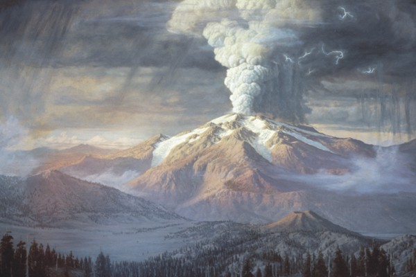
Listen to the startling story in which geology gives us a picture of creation days in this mysterious region – the story of Mt. Mazama.Once a great mountain reared a smoking peak many thousands of feet above the present peaceful level of Crater Lake. Away to the northward stood other volcanoes – Baker, Rainier, Adams, St. Helens, Hood, Jefferson, and noble Mt. Multnomah which towered above the present region of the Three Sisters, while to the southward were Shasta and Lassen, all of which helped build the Cascade Mountains. Most of these old volcanoes stand today quiet and cold in their shining armor of snow and ice – but Multnomah and Mazama are missing.

Evidently there came a day when Mt. Mazama poured forth vast quantities of lava, creating a great cavern beneath, and then collapsed and sank within the grave it had made for itself. This drawing shows the bare outline of Mt. Mazama as it must have towered in its greatest days.

Want to know more? Check out the Wikipedia article and USGS page entitled “Mount Mazama and Crater Lake: Growth and Destruction of a Cascade Volcano“.

More trips! Join us and take a tour of Crater Lake…

Who can resist the brilliance of Crater Lake? Wizard Island, Mt. Mazama, Phantom Ship, the Pallisades, a really cool lodge – it’s another great hand-colored set from the Visual Instruction Department Lantern Slide Collection!

Again, we’re lucky to have such great slide descriptions from the booklets – they must be quoted, so please check the descriptions under each for more details! Who can resist these directions?

“Crater Lake National Park may be reached from Medford, Oregon, on the Southern Pacific Railway, and on the Pacific Highway about 36 miles from the southern boundary of Oregon, or from Kirk, on the new Southern Pacific line between Eugene and Klamath Falls and near The Dalles – [aka] ‘California Highway.’

Motorists southbound from Portland may choose to traverse the Pacific Highway through Oregon City, Salem, and Albany, or go by the West Side Highway through Newberg, McMinnville, Corvallis, and Junction City where this road merges with the Pacific Highway [which] leads through Eugene, Roseberg, Grants Pass, and Medford. From Medford, the distance to Crater Lake is about 80 miles.”

And look what you can find on Google books? This 1916 text on the Crater Lake set from “Pictured knowledge: visual instruction practically applied for the home and school” by Calvin Noyes Kendall and Eleanor Atkinson.

Where is Crater Lake and why is it such a marvel? To quote the National Park Service site:

“Crater Lake has inspired people for hundreds of years. No place else on earth combines a deep, pure lake, so blue in color; sheer surrounding cliffs, almost two thousand feet high; two picturesque islands; and a violent volcanic past. It is a place of immeasurable beauty, and an outstanding outdoor laboratory and classroom.”

And, as usual, Wikipedia gives us some great information and even better links to follow to find out more.

And yes, we have more shots of Crater Lake in the Archives! Check out the inventories for The Herman T. Bohlman, The Ralph I. Gifford, and The John Garman photographic collections.

150,000 views!

For those of you keeping track, we hit 150,000 views in our Flickr Commons account this weekend! So I send out a hearty thanks to all our loyal viewers and all our new friends — we wouldn’t be here without you.

And remember, we launch new sets every first and third Wednesday and you can set up an RSS feed so you don’t miss a single thing.

What’s coming? This week we’re heading to Crater Lake, care of the Visual Instruction Department Lantern slide collection. Here’s a sneak peek for those of you who can’t wait.

After that, we’re staying with this collection, but shifting to another great series of images from Oregon Industry, circa 1905, 1925, and 1940.

The beauty of an accidental discovery…

Picture this: it’s a Thursday morning, Corvallis is clouded over and feels more like like March or October than the middle of August. With scrawled notes and poorly drawn wire frames for our new web site scattered over every surface of the Archives reference desk, we were deep in talks about the “about” page — with a few diversions into chats about our Flickr-verse and the 150,000 views milestone we are rushing towards. A professor from a neighboring university arrives to look at our Sanborn maps; she’s looking for maps of Portland from the late 19th and early 20th centuries.

“Sanborn Maps were originally created for assessing fire insurance liability in urbanized areas in the United States. The maps include detailed information regarding town and building information in approximately 12,000 U.S. towns and cities from 1867 to 1970. Author Kim Keister describes the legacy of Sanborn maps: “Stated simply, the Sanborn maps survive as a guide to American urbanization that is unrivaled by other cartography and, for that matter, by few documentary resources of any kind.” They are a highly useful resource for historical research, planning, preservation, genealogical research, sociological studies and research of urban geography.”

After a few false starts, like the one that took me to the usual case I would go to for Sanborn maps, we located the case with the 1897 and 1907 maps she wanted in the big map cases that also hold some of our historic maps and oversized archives. Then, and this is one of those magical archives moments, as I am opening the case I see the label: “Portland 1905, Lewis & Clark Exposition.” And what did I find? Yes, in addition to mapping the buildings in Portland at the turn of the 20th century, the Sanborn Insurance Company had also mapped the buildings of the 1905 Expo. You can view the two beautifully detailed and color coded maps here.

Take the time to zoom in…

Look for the “Infant Incubator Building,” the “Forestry Building,” the “Oriental Building.” See if you can read the names on the little shops or the big showcase buildings. And take note of the upper right corner, which gives you information about the water supply, fire department, and construction of the buildings. Also, if you are a little confused about where the Expo was located, understandable because none of these buildings still stand, click the “map” (which you’ll find under the “additional information” on the right side of the screen) to orient yourself.

And, for those concerned about our poor patron and her place in my excited frenzy that followed, she was as thrilled as we were and happily abandoned her research (temporarily) to “oooh” and “ahhh” with us! And yes, then she dutifully returned to her maps and found what she needed…

New Exhibit at LaSells Stewart Center

The OSU Archives has a lot of great images of food…

Want to see Braceros workers harvesting potatoes? A 1920s Horticulture show in the Men’s Gymnasium main floor?

And what about canning? Perhaps you are interested in a portable community cannery? Or other canning shots of women canning beans, a woman canning cheese, canned maraschino cherries?

But what if you want some contemporary images? A new exhibit, featuring the bounty of Oregon agriculture and a reflection of the role Oregon State University’s agricultural research plays in sustaining our state’s rich farming heritage opens today. After a show in the Murdoch Gallery at the LaSells Stewart Center at Oregon State University, the Savory Images photo exhibit begins a tour across the state and is available for month-long display during 2009-2010, free of charge.

Photos are by award-winning photographer Lynn Ketchum and from the pages of the acclaimed magazine Oregon’s Agricultural Progress. Check out the site for the traveling exhibit — it’s beautiful! Just make sure your stomach is full…

New to our reference shelf…

A detailed study of American public radio’s early history: Radio’s Hidden Voice: The Origins of Public Broadcasting in the United States, by Hugh Richard Slotten.

“Employing extensive research from archives across the United States, Hugh Richard Slotten examines the origins of alternative broadcasting models based especially on a commitment to providing noncommercial service for the public. These stations, operated largely by universities and colleges, offered diverse forms of programming meant not merely to entertain but also to educate, inform, enlighten, and uplift local citizens.” Want to know more?

Finding Aids

The following 9 finding aids for OSU Archives collections were completed or updated in July 2009. They have been loaded to the NWDA finding aids database and have a PDF on the OSU Archives’ website. MARC records for all of the collections are available through the OSU Libraries’ Catalog, Summit Navigator, and Worldcat. One of the collections was received in 2009; four are for collections for which there was previously no information available online. The OSU Archives now has 418 finding aids in NWDA.

Most of these are new finding aids; one (for the Technology Educators of Oregon Records) is an update of an existing finding aid.

A Dairy Program for Oregon Scrapbook, 1929

Graham, Robert D., Papers, 1903-1973

Home Economics, College of, Oral Histories, 1968-1985 (OH 11)

Home Economics, College of, Motion Picture Films and Videotapes, 1950-1998 (FV P 044)

Landscape Architecture Department Records, 1932-1982 (RG 089)

Rodman, Wilma M., Photograph Collection, 1950-1974 (P 147)

Science, College of, Videotapes, 1991-1997 (FV P 084)

Technology Educators of Oregon Records, 1954-2001

Walls, Robert B., Collection, 1916-1974