This year’s conference for the Northwest Archivists (NWA) was held in Tacoma, Washington. The theme was Grit and Memory. Lasting three days, the annual meeting included workshops, panels, presentations, and special events like a screening night and a tour of the Washington State Historical Research Center. As a Student Archivist here at OSU and an MLIS student at the University of Washington iSchool, attending the conference was an exciting and valuable experience.
This event was my first in-person NWA conference, and my first time being on the Program Committee for NWA. The process began in November of 2025, when our first Program Committee meeting was held, and we continued with regular meetings through June of 2026. I was able to offer the perspective of MLIS students to the committee, as well as my connections to the University of Washington student population through our listservs and social media. The bulk of our work consisted of outreach for session proposals, fielding said proposals, organizing the schedule, and putting together the program, among many other tasks. Having had event planning experience in my previous roles, being on this committee was a very nice bridge connecting my past work to my current work.
On the first day of the conference, I attended a tour of the Washington State Historical Research Center and the opening reception at the University of Puget Sound. The tour included an overview of the research center’s stacks, and we got a peek at their methods for digitization and scanning. We took a brief trip into their cold storage room, which was incredible and spacious. Our group was also lucky enough to see a wagon from the Oregon Trail:
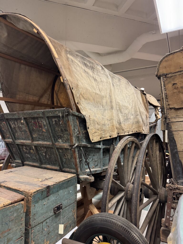
It was all in all, a very fun tour and a very interesting look at how one institution handles such a large volume of items!
The next event I attended was the opening reception, held in the Collins Memorial Library at the University of Puget Sound. It was a casual networking event, where I was able to meet several wonderful people! Among them were Stephanie Plowman, the Special Collections Librarian at Gonzaga University, Alexis Hickey, the Archivist and Head of Special Collections at Whitman College, and Hannah Morrison, the Archivist at the University of Puget Sound.
The following day, I started by visiting the Washington State Library booth, where I met Shawn Schollmeyer, who is the Washington Digital Newspapers Coordinator there. She shared her work with me, and also talked briefly about the Washington Talking Book & Braille Library, which has come up in my coursework at UW as well. There was then a wonderful keynote by Jill La Pointe, who spoke about archives and cultural preservation, followed by several conference sessions. The first session I attended was Carlos Pelley’s talk, titled ‘Using Archival Resources for Public History’. He shared the ways that his institution has used archival resources to encourage library engagement and to aid in community needs. He also provided guidance on how other institutions can use specific language and data points to validate their requests for various resources like funding. This was one of three sessions for which I was a liaison as part of my role in the Program Committee. This included aiding in setup and takedown, being on hand for any IT issues, keeping time, taking headcounts, and facilitating questions as needed.
The next session was another I was liaising for, and was from our very own Karl McCreary, and was a joint case study session in which Steve Bingo and John Klint were also presenting. Karl’s presentation, ‘Bird Nerds’ discussed four of our collections within SCARC that relied on citizen science, emphasizing the importance of community-based collections. Steve and John, both from Eastern Washington University, presented ‘Geography of Hope’, discussing the process of their work on the Turnbull National Wildlife Refuge collection. Their case study tied in nicely with Karl’s, examining the perseverance of those who worked on the refuge.
For the final session of the day, I attended another joint case study, this time between Stephanie Lamson and Claire Kenney on conservation services at the University of Washington, and Tish Stringer showcasing 1930 Kodacolor film from the University of Oregon. The first case study followed the process of UW’s conservation over the past few years, while the second looked at a rare type of color film that had recently been preserved and made accessible. Besides one presentation hosted at OSU, this was my only encounter with digital preservation. Tish gave a brief review on how this type of color film worked, and how the UO team was able to convert it from black and white to color.
The last event of the night was a screening hosted by the Moving Image Preservation of Puget Sound (MIPoPS), held in the Collins Memorial Library at the University of Puget Sound. The evening featured archival film from a variety of institutions, including OSU. A few of my favorites included a film from the 1930s of Alaska’s west coast, another 1930s clip of a home movie from the Williams Family of Celilo Falls, and two University of Puget Sound student films from the 1980s.
On the last day of the conference, I attended the Native American Collections Roundtable (NACR) session. This was the first archival round table I had ever experienced, and was also my first encounter with NACR. Topics of discussion included reviewing priorities for the group, looking at how to connect various groups of shared interest, how NACR can support various archival institutions, and how NACR can further integrate with NWA. I really enjoyed how so many people of different positions pushed to support each other while advocating for their own needs as well.
Next, I attended my last liaison session, which was for Libby Hopfauf from the Seattle Municipal Archives and MIPoPS, and Andrew Weaver from the University of Washington. This session was another round table, this time for the Audio and Moving Images interest group. The group discussed needs and concerns, ways to share resources and information that is localized to the northwest region, creating a service and repair directory, supporting networking and professional development opportunities among digital preservationists, and ways that the group could support other interest groups and round tables.
The final session of the conference was a case study by Heather Mulliner from the University of Montana, who was also on the Program Committee with me. She presented on the creation of oral history kits for student use at her institution, covering the entire process from funding to implementation. This presentation was fantastic and gave me much to consider when it comes to OSU’s oral history projects.
Closing thoughts on the conference:
Being able to attend this year’s NWA meeting, and to be involved on the Program Committee, was a wonderful experience! I learned so much, not only about how a conference comes together and all the work that happened behind the scenes, but during the actual conference, I learned about how wide the range of archival work really spans. The best part was meeting so many people who clearly have such passion for their work, and who have dedicated so much time and energy into this field. It really widened my perspective on what archives and preservation work can look like, and gave me hope that I’ll be able to find my own niche in the future.
~ Sabrina She, SCARC OSQA/OMA Student Archivist
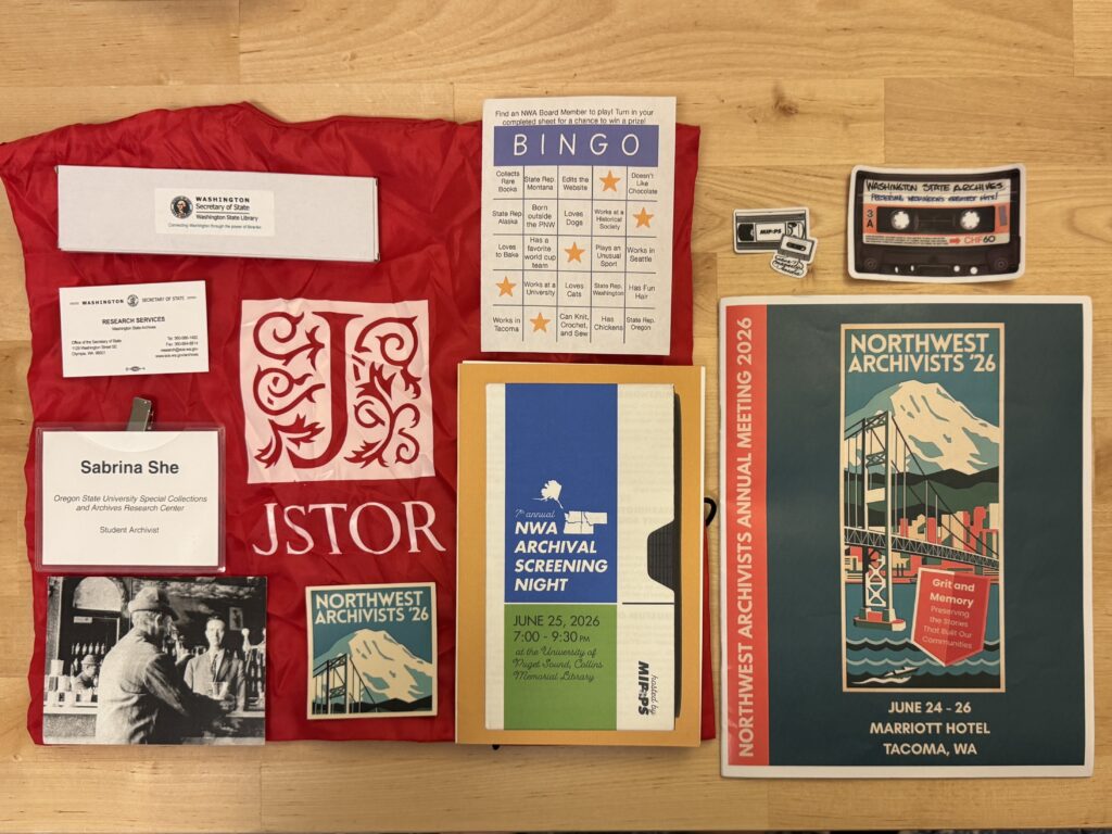
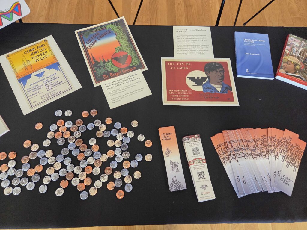
P. S. I collected as much merch as I could: