
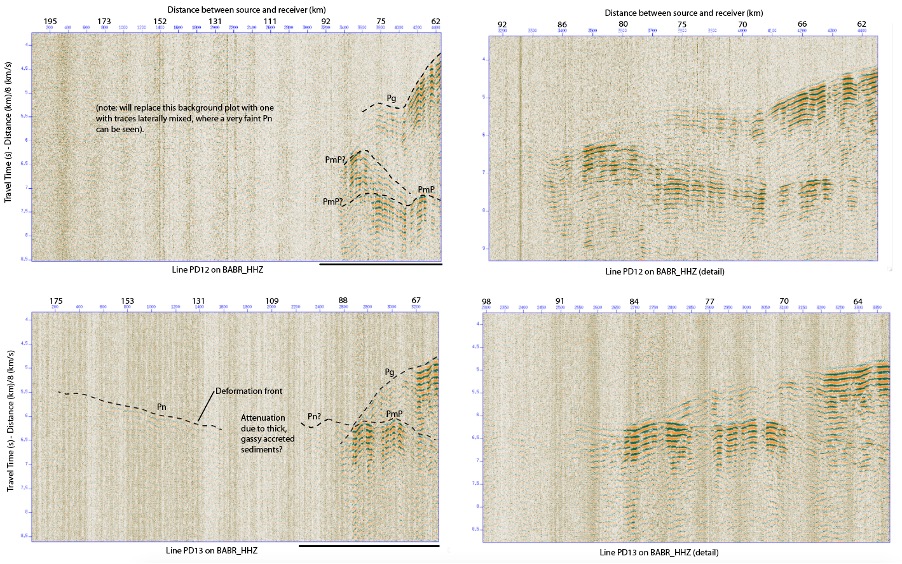
Although the data from the nodes must be downloaded at the IRIS/PASSCAL instrument center (a national facility that provides seismological instrumentation to universities throughout the US for experiments around the globe), we can get a first look at the data by processing the data recorded on stations from the Pacific Northwest Seismic Network (PNSN) and on 5 temporary stations that were provided for this experiment by Nanometrics Inc. An example of data from two different offshore lines (PD12 and PD13) as recorded on PNSN station BABR is very promising. Sources along these two offshore lines travel a different path to the station, as shown by the triangles on the map.

For an animation of the process of extracting information on subsurface structure from seismic data, see this short video from IRIS.
If the crustal structure were uniform along this portion of the Cascadia margin, the data from the two lines would look the same at this station. However, we see that they are quite different, indicating that there are 3-D structural variations in the subsurface. Some of the differences to note include:
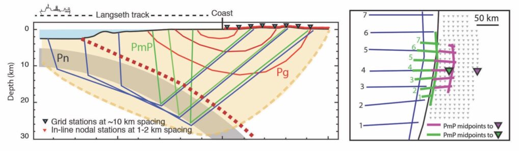
- Different amplitude of the weak energy arriving from very distant shots labeled Pn in the data. These are arrivals that travel in the uppermost mantle below the crust. These arrivals are observed without the need to smooth data laterally on both BABR and NANO4 for sources along PD13. They are present but much fainter on these stations for source along PD12, indicating either that the sediment overlying the subducting plate along PD12 attenuates the energy more strongly than along PD13 or that differences in(?) deep structure leads to attenuation of the energy.
- The first arrival patterns show inflections in a different place for the two source lines, signaling structural difference in the upper plate. These will be mapped into a 3-D model using first arrival tomography, a mathematical approach to processing and interpreting these data that is analogous to a CAT scan.
- Strong Pg and PmP arrivals in the source-to-seismometer distance range of 60-90 km, which represents energy sensitive to plate boundary structure in the region where great earthquakes originate.
- Possible bifurcation of PmP into two waves with different arrival times for sources along PD12. This could be due to complex 3-D crustal structure. Analysis of the entire data set is need to test this hypothesis.
Similar patterns are seen on NANO4, indicating that these differences are due to regional variations rather than to local site effects. Somewhat different patterns are seen for these two lines of sources on other stations in this region, providing information that will be mapped into structural variation as analysis proceeds. Spot checks of PNSN stations in SW Washington (PNSN station RADR) and near the Oregon/California border (PNSN station KBO) indicate that the observations in the northern and southern parts of the onshore network are very different from those in the middle, signaling large variations in the dip of the subducting plate and the composition of the upper plate beneath Cascadia.
The data shown here represent less than 0.01% of the entire data set, and all the data have to be processed, modeled and interpreted. We anticipate that these results will lead to significant refinement of the depth and character of the subducting slab. This is important because studies of subductions zone elsewhere that have experienced great earthquakes in recent years suggest that the geologic characteristics of the plate boundary and adjacent plates exert a strong influence on the rupture process of great earthquakes, which in turn affects the pattern of strong ground shaking and other hazards, such as landslides, that result from the shaking.
-Anne Tréhu