Week Ten: Eclipse! (and whales, birds, and seals)

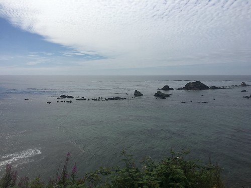
These last couple weeks of my internship have been a lot of tying up loose ends. Last week, I was busy getting prepared for the final presentation and poster for the symposium in Newport. It took a lot of work, but it was fun to bring together everything that I’ve been working on this summer and show what we’ve been doing at the South Slough. I’ve also been trying to go explore places in Coos Bay one more time before I leave. Earlier last week, I drove down the Cape Arago peninsula again, and this time I finally saw seals at Simpson Reef! The day was really clear, so there was no fog obstructing the view of the rocks, and it was at low tide, so the maximum amount of rock was exposed for seals to haul out on.

This picture basically just looks like big rocks, but they’re covered in seals:

IMG_3906

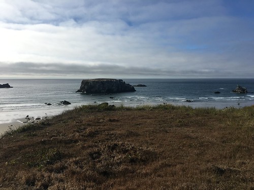
I also went to the Bandon Marsh National Wildlife Refuge and spent some time birdwatching. At the shore at Coquille Point, there were tons of gulls and cormorants on the large rock outcrops and feeding along the intertidal. Along the emergent saltmarsh at the Ni-les’tun Unit, I saw swallows and sparrows, a great egret, a turkey vulture, and a peregrine falcon.

The big rock outcrops at Coquille Point in the Bandon Marsh National Wildlife Refuge:

IMG_3916

However, the past few weeks haven’t been all lasts, but also some new things.

  • I finally saw whales in Oregon! Katie and I were heading up north from Newport after the symposium and stopped in Depoe Bay. Depoe Bay claims to have the world’s smallest harbor—and it is a perfect spot for whale watching. Over the course of a couple hours that we sat overlooking the bay, we saw hundreds of grey whale spouts, tons of whale backs, and a couple shots of flukes. I was so happy that I got to see whales before I left Oregon!!
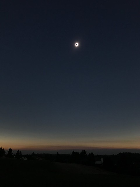
  • The best new thing—the eclipse. We were really lucky that the eclipse was happening this Monday, August 21st, only a couple days after our symposium in Newport. The path of totality passed right through Newport inland across Oregon. Coos Bay would see about 97% totality, but Katie and I decided to stay with my mom and sister at a friend’s house in Salem so that we could see the total eclipse.

We were really surprised there was basically no traffic getting to Newport or from Newport to Salem, because we had heard dire warnings about the millions of people coming to Oregon for the eclipse. On Sunday, we went to Silver Fall State Park, hiking an 8-mile loop that brings you past about 7 waterfalls. It was an awesome way to kill time before the eclipse.

Monday, Katie and I woke up early to claim a spot at a local golf course to view the eclipse. We definitely could have slept in a bit later, as only a couple dozen people ended up watching from the course. My family and friends came a bit later with food. It was amazing to just sit for the next couple hours, watching the moon slowly cover the sun. I had heard what eclipses would be like, but no description really prepared me for experiencing it. As totality neared, it got eerily dim and felt like I was looking at everything through a filter. Then the moon fully covered the sun, and it was instantly really dark. Streetlights came on, the horizon looked like sunset, and you could see the corona around the moon. The two minutes of totality felt like seconds. Before we knew it, the sun peeked out behind the moon, and we had to put our eclipse glasses back on.

My attempt to take a picture of the eclipse with my phone:

IMG_3911

This whole summer—the fieldwork, research, hiking, camping—has been incredible, but I feel lucky that I got to end the summer with a once-in-a-lifetime experience that I may not have been able to see if I’d been somewhere else.

Week 7: South Slough fishes

This past week was devoted to the August fish seining in South Slough. Since I already spent one blog post describing the process (http://wp.me/p64Blw-1cd), I figured that for my blog post this week I would highlight some of the fish species that we have been encountering during the seining.

The Pacific staghorn sculpin (Leptocottus armatus) is commonly found in South Slough. It has spiky projection on its gill cover that it can raise when threatened. They also sometimes vibrate when threatened. Here’s a tiny staghorn sculpin:

IMG_0546

And a bigger one:

IMG_0548

Many different species of perch live in the South Slough, including Shiner perch (Cymatogaster agregata), White seaperch (Phanerodon furcatus), Walleye surfperch (Hyperprosopon argenteum), silver surfperch (Hyperprosopon ellipticum) and Pile perch (Rhacochilus vacca).

This week we caught a striped seaperch (Embiotoca lateralis):

IMG_0542

We also get a few different species of flatfish (fish that live on the seafloor and swim on their side, with both eyes on one side of their body). English sole (Parophrys vetulus) are most common, but there are also Speckled sanddab (Citharichthys stigmaeus), and starry flounder (Platichthys stellatus). We got a huge starry flounder this week, which was really unusual.

A tiny English sole:

IMG_0544

And a starry flounder:

IMG_0555

We also caught a bay pipefish (Syngnathus leptorhynchus). Bay pipefish live in eelgrass beds, and their bodies mimic a strand of eelgrass. Pipefish are related to seahorses, and the males incubate the eggs, just like seahorses.

IMG_0552

Juvenile Chinook salmon (Oncorhynchus tshawytscha) also appear pretty frequently. There are both wild Chinook and hatchery-raised Chinook. We can tell wild-born from hatchery-raised Chinook from the adipose fin (a small fin behind the dorsal fin): hatchery Chinook have their adipose fin clipped, while wild Chinook do not.

IMG_0550

It’s been so much fun seining and learning about the different fish in the South Slough this summer. I’m going to miss it!

Week 6: Crater Lake

This past weekend, a bunch of the Sea Grant scholars went to Crater Lake National Park. I had only ever been to one other national park, so since Crater Lake is only a few hours from Charleston, it was one of the top things on my list to see this summer.

We first hiked to Garfield Peak, a trail that winds along the ridge of Crater Lake to a high peak that lets you see views of the lake and mountains to the north and south. The trail passes through fields with wildflowers and groves of hemlocks, pines and firs. There were so many butterflies and bees around! There was still snow remaining towards the end of the trail that we had to cross to reach the top of the peak, but it had been compacted down and was pretty easy to cross. It was still a bit of a strange experience to hike through snow in the summer.

20604289_10207714380336004_1311487156249470377_n

20638660_10207714382136049_3436199858274942379_n

At the top of the peak, the views of Crater Lake and the area were beautiful. At points along the trail, you could see Cascades to the north (including one of the Sisters) and south and Mt. Shasta way off in the distance. The water in the lake was completely still when we first arrived, creating a perfect mirror of the sky, caldera, and Wizard Island.

20604153_10207714377575935_3247284346243009230_n

20597310_10207714384776115_419001449734846994_n

After hiking Garfield Peak, we drove around the rim of the lake to Cleetwood Cove Trail, the only place that the water can be accessed at Crater Lake. It was a short and steep trail down to the water, where we then could jump in and swim. Though the water was cold, it was not nearly as freezing as Tamolitch Falls, so we were actually able to stay swimming in the water for about 30 minutes. It was so cool to be at the bottom of the caldera, in the water, looking up at the cliffs.

crater_lake_1

We then continued to drive on Rim Road, circumnavigating the entire lake, and stopped along the way to enjoy the view. We eventually made it back to Crater Lake Lodge in the evening, where we decided to have a drink and sit on the deck overlooking Crater Lake. It was a great end to an awesome weekend!

Crater_lake_2

IMG_3888 (1)

P.S. Thank you to Katie Gregory for letting me use all her pictures since I never take any!

Week 5: Sharing the word about green crabs

IMG_3880

July has passed in a blur, and it’s somehow already August, with only four weeks left in Oregon. I’ve had–during the Sea Grant camping trip to the Tamolitch blue pool, and Crater Lake National Park—which I’ll hopefully get to in another blog post. This week, though, I wanted to give an update on the green crab work numbers in Coos Bay since they were first found in 1998. Last year, a total of around 200 crabs were caught throughout all of Coos Bay, including in South Slough. So far this year, more than 1,500 crabs have been caught in the estuary.

Before getting into more detail, I want to explain a technicality that makes understanding the data easier. We use something called Catch Per Unit Effort (CPUE) for our measurement of crab abundance as a way to standardize crab numbers. CPUE is calculated by dividing the total number of crabs caught by the number of traps set. In this way, we can control for the number of crabs by the trapping effort. If we used just abundance numbers (like the 200 crabs caught in 2016 and 1,500 in 2017) to compare between sites or between years, our values might be impacted by the fact that we set a different number of traps at each site or year. Using CPUE allows us to more directly compare crab abundance.

So, back to the data. Luckily for the South Slough, the drastic increase in green crab abundance seen in Coos Bay has been almost entirely restricted to the upper part of the Coos Bay and not in the South Slough specifically. While a couple sites in South Slough have seen a CPUE increase of about 0.5—1 crabs/trap, a couple other sites in the South Slough have actually decreased by about the same amount compared to last year. In the other side of Coos Bay, though, the CPUE has increased by 15 crabs/trap/day—more than a 600% increase!

The map below shows the change in CPUE across all sites in the different parts of the Coos Estuary. The triangles show where green crabs were present in 2016. You can see from the colored circles that the Upper Bay has seen a much higher increase in CPUE than the South Slough.

Slide1

Because of the massive increase in green crabs this year, we are trying to get the word out to the community. I have encountered people a few times while out doing fieldwork that ask questions about what we’re doing, which provides a great opportunity to share about green crabs and let them know about the issue. We’ve printed flyers that we can hand out to the community with information on how to identify green crabs, why they are a problem, and what to do if they are found. I am going to continue outreach about green crabs by updating the information flyer and distributing them around.

The human community members we’ve encountered have been great to talk to, but the dog community members have been even better. One of our field sites has two dogs that have joined us every time we’ve been there. They live in a house somewhere behind our field site, but I’m not exactly sure where, because every time we are there they just come running down the hill through a patch of forest behind the beach and join us for crab trap setting.

A good dog:

IMG_3886

Also a good dog:

IMG_3883

They are really helpful workers and will be great scientists someday 12/10

IMG_3882

IMG_3879

Week Four: Fish Seining Begins

The South Slough–and estuaries in general–are important spawning and nursery grounds for many marine fish species. However, the last time that there was a comprehensive assessment of the fish community in the South Slough was back in 1987. So approximately two years ago, the South Slough received funding to monitor the fish populations again. Once a week almost every month, a set of six sites are sampled at high and low tide. The information on the species and number of fish caught in each sample helps the reserve understand how fish communities in the slough are changing across seasons and years in different parts of the estuary. By combining this species abundance and richness data with water quality data, they can also assess how environmental conditions influence species presence, absence, and abundance. Overall, this project aims to characterize long-term trends in habitat use by fish, and it can additionally help evaluate the effectiveness of past restoration efforts.

This fish monitoring project is the other main part of my internship with South Slough, in addition to the green crab work, and this week was the first fish sampling week scheduled since I started my internship. So starting this Monday, my time this week was almost entirely spent with fish work. The method used for the fish monitoring is called seining. Seining consists of a large net that hangs vertically in the water, with a float line on the top and a weighted line on the bottom. As the net is deployed along the shore, the weighted line drops the net to the bottom of the water and the float line keeps it buoyed on the water surface, creating a large barrier that scoops up all the fish in the seine net area.

To deploy the seine net, we first set a person on shore as the anchor, holding a rope at one end of the net. Then a person on the boat deploys the net from the bow, creating an arc near the shore.

IMG_0490

IMG_0491

IMG_0494

Two people then each hold one end of the net, and haul the net through the water to the shore.

IMG_0495

IMG_0497

IMG_0496

Once the net reaches the shore, everything in the net is funneled to the bag at the bottom of the net. All the fish and crabs in the net are then placed in buckets (with oxygenators).

IMG_0500 (1)

IMG_0503

IMG_0502

All of the fish and crabs caught are then identified, and their length and weight are measured.

IMG_0469 (1)

This week, we caught dozens of different kinds of fish and crabs–Chinook salmon juveniles (both wild and hatchery-released), different kinds of perch and sole, herring, anchovies, pipefish, and more.

IMG_0472

IMG_0475

It was exciting to learn new field techniques and to become better with fish identification as the week went on. The next week of fish seining will be sometime in August, and I’m excited to do it all again!

Week Three: exploring Oregon

In addition to the fun of catching green crabs over the past few weeks, I have also been able to explore some of the sites around Charleston and in central Oregon.

In just a 20 minute drive from the South Slough offices down Cape Arago Highway, there are a series of beautiful spots along the coast. One afternoon a couple weeks ago, Katie and I decided to just start driving and see what we could find.

A view of Sunset Beach (PC: Katie Gregory)

We first hit Bastendorff Beach, a long, sandy strip of beach that always has plenty of open space to have a bonfire or just sit and enjoy the view of the ocean. I’ve seen people surfing and paddleboarding, but I have only managed to get my toes in because the water is freezing so I’m not sure how the surfers manage.

We then got to Sunset Beach, but for some reason the park closes at 9 pm–before the sunset during the summer–so despite the name, I have yet to see the sunset at Sunset Beach. It’s still a gorgeous beach, with sandy shores surrounded by tall rocky cliffs. Simpson Reef is one of the best spots to view pinnipeds on the southern coast. The cliff overlooks large rocky islands right offshore where harbor seals, northern elephant seals, Steller sea lions, and California sea lions congregate. By the time we got there, the fog had started to roll in so we couldn’t see anything, but we could hear a lot of seals! Lastly, we got to Cape Arago State Park, the end of Cape Arago Highway, where we followed a few trails to spots where you could see the extensive rocky outcrops that line the coast. The trail down to the beach was closed due to seal pupping season, but hopefully we’ll be able to make it back later in the summer.

Last weekend, Katie and I decided to head the other direction and explore the sand dunes north of Charleston. We decided to hike the John Dellenback Trail, a 6-mile roundtrip trail that goes through a small forest, across a stretch of sand dunes, and then through a marshy forest to the ocean. Hiking across the dunes, where everywhere you look around you is sand except for a stretch of trees out in the distance, feels like you’re in the Sahara, not southern Oregon. But then you get to the swampy strip of forest, and the long expanse of ocean, and it feels like Oregon again.

More sand dunes, with some people included for scale. (PC: Katie Gregory)

Sand dunes at the John Dellenback Trail. (PC: Katie Gregory)


Last weekend, Katie and I decided to head the other direction and explore the sand dunes north of Charleston. We decided to hike the John Dellenback Trail, a 6-mile roundtrip trail that goes through a small forest, across a stretch of sand dunes, and then through a marshy forest to the ocean. Hiking across the dunes, where everywhere you look around you is sand except for a stretch of trees out in the distance, feels like you’re in the Sahara, not southern Oregon. But then you get to the swampy strip of forest, and the long expanse of ocean, and it feels like Oregon again.

For the 4th of July, I left the coast behind and visited family vacationing in Bend, located in central Oregon near the Willamette National Forest. The drive from Charleston to Bend was gorgeous, passing through endless forest and past large mountain lakes. We hiked Tumalo Falls, though we didn’t make it through the entire loop because my seven- and eight-year-old cousins were getting tired. We also floated in tubes down the Deschutes River, drank some beer from local breweries, and ate some amazing gelato. It was awesome to be able to see a completely different part of Oregon. It was sunny and hot (over 90 degrees, whoo!), and though I love the southern coast, it was nice to be able to wear shorts, have to put on sunscreen, and swim in the river without wearing waders.

Tubing down the Deschutes:

19657472_10213685601482372_499725847766661033_n

tubing

Tumalo Falls:

tomalo falls

19657164_10213689040888355_3135239411633128299_n

I’m looking forward to seeing more of the area (I’m hoping to make it to the northern part of the redwoods and to Crater Lake) over the rest of the summer.

(Also, thanks to Katie for letting me use all your pictures since I never take any!)

Week 2: Mud and Eelgrass

This week, green crab monitoring was in full swing. We sampled across five different sites throughout the South Slough, setting 12 crab traps at each site. Everything went pretty smoothly—except for getting stuck to the mud up to our thighs at one point. We had been warned about the mud here, but we were not quite ready for what that could actually entail. As I walked toward the small stream of water still remaining at low tide, my boots started sinking more and more into the mud until I was up to my thigh. Another intern came over to help, and then she got stuck too. We were eventually able to get our feet out of our boots and army-crawl out, and then had to dig our boots out as well. My entire lower body and arms were covered in thick, sulfurous mud. I wish I had pictures, but we were too covered in mud to touch our phones. It was all worth it, though; so far, we’ve caught green crabs at every site, for a total of about 40 crabs across all sites. In the other side of Coos Bay, they have been even more abundant this year. Another researcher caught over 100 green crabs within one day. As we continue to re-sample sites throughout the next few weeks, we will be able to more accurately compare their abundance to previous years and provide a more complete assessment of the population trend.

Because green crabs will be a majority of my time here and I will be writing about them frequently, I thought I would take a digression and also write about an eelgrass research project that I assisted on this week. Eelgrass (Zostera marina) is a seagrass that can form dense beds along bays and estuaries. These beds provide important habitat and nurseries for many shellfish and fish and provide feeding ground for birds and other wildlife. Eelgrass has been declining throughout the United States, with various natural and anthropogenic causes: nutrient runoff, invasive competitors, shellfish harvesting practices, rising temperatures and sea levels, and eelgrass wasting disease.

Researchers from Oregon State University are conducting a multi-year study on eelgrass decline along the Oregon coast, including sites in Coos Bay. We took a boat out to two sites with dense eelgrass beds. We then navigated to approximately 40 randomly selected GPS coordinates throughout the site. At each GPS point, we counted the number of eelgrass shoots within a .25x.25 m square (called a quadrat) and collected a single eelgrass shoot and all of the algae present within the quadrat. These samples of eelgrass and algae will be processed later for various measurements, including quantifying the biomass and the number of epizoa (animals living on the surface of the eelgrass). Even just spending a few hours in the eelgrass beds offers a glimpse of how much life they can support. We saw baby starfish smaller than a pinky nail clinging to eelgrass, countless shellfish and crabs, and birds such as gulls, cormorants, and even a few Great Blue Heron out on the eelgrass beds at low tide, searching for food. It was a beautiful place to spend some time doing research.


The eelgrass bed site (called Clam Island) that we sampled at low tide. At low tide, the eelgrass is matted down as the water recedes. But as the tide rises, the water will allow the eelgrass to lift up, and it will more resemble a forest of grass.

Another intern and I counting eelgrass shoots at one GPS coordinate at Clam Island. The white square is called a quadrat: at each GPS coordinate, the number of eelgrass shoots within the quadrat were counted and algae and eelgrass from within the quadrat were collected.

Me standing at the edge of Clam Island where the water is starting to come back in as the tide rises. (My eyes are open this time!).


More information about eelgrass:

http://www.habitat.noaa.gov/abouthabitat/eelgrass.html

Week One: Green Crabs

This summer, I will be interning for the South Slough Estuarine Research Reserve (SSERR), near Coos Bay, Oregon. I mainly will be working on monitoring European green crabs (Carcinus maenas), one of the most invasive marine species. Native to the Atlantic coast of Europe and northern Africa, green crabs were first documented on the East coast of the U.S. in the mid-1800’s and in California in 1989. Green crab presence was first documented in Coos Bay in 1998. Green crabs can out-compete juvenile Dungeness crabs (Metacarcinus magister) and disrupt native communities, including negatively impacting commercially important shellfish and eelgrass populations.

The SSERR has continued to monitor the green crab populations in the South Slough and Coos Bay since their discovery. Though the population has cycled through years of high and low abundance since the species was first documented in the region, the last couple years have seen a spike in green crab abundance. Along with other interns and staff, one of my main roles this summer will be to continue monitoring efforts throughout the South Slough, tracking their distribution and abundance at various points throughout the estuary.

This week, after settling in to my housing and meeting the green crab team and the rest of the staff, my first task was to conduct inventory on all the green crab trapping equipment to prepare for the season’s fieldwork. We use two main traps in the green crab research: 1) Fukui traps, and 2) Minnow traps. Fukui traps are intended to capture adult crabs, while minnow traps are aimed at smaller juvenile crabs.

Thursday and Friday were our first days out in the field. Traps have to be set during the morning low tide, and then are left until the low tide the following morning. On Thursday, we set traps at 2 sites in the estuary, and on Friday, we retrieved crabs from the traps.

Setting a fukui trap in the Metfield site in Charleston, OR.

Me holding a green crab caught in one of the traps. All of the green crabs caught are weighed and measured, and their sex, abdomen color, and number of missing limbs recorded. (My eyes were closed in every picture taken.)

Retrieving crabs in a fukui trap at the second site. Dungeness crabs, Oregon shore crabs, and sculpin (a fish) are also often caught in the traps. This site was extremely muddy, and we all got our boots stuck multiple times.


These two days of fieldwork were just a brief start to the green crab project, and we will continue monitoring at several sites throughout the estuary for the rest of the summer. Collecting data on green crab abundance and distribution will help us better understand their population in the region and hopefully mitigate and prevent damage to the native ecosystem.