

Much of the research done by our group — such as understanding sediment transport, wave breaking, and currents — relies on accurate measurements of water flow in a dynamic environment. This has led us to develop new sensing techniques and algorithms to meet the requirements of field research, such as acoustics for underwater flow and sediment transport, and imaging the nearshore zone using video cameras and lidar. One such instrument is the Surface Velocity Scanner (SVS), which combines high-resolution LIDAR and video to measure water flow.
The SVS was initially developed as a UAS (drone) video imaging technique: An example is shown below in image pixel coordinates, representing approximately 20×40 meters area with a sampling resolution of about 10×10 cm. These data are from the ROXSI rocky shorelines experiment in Hopkins CA, 2023.
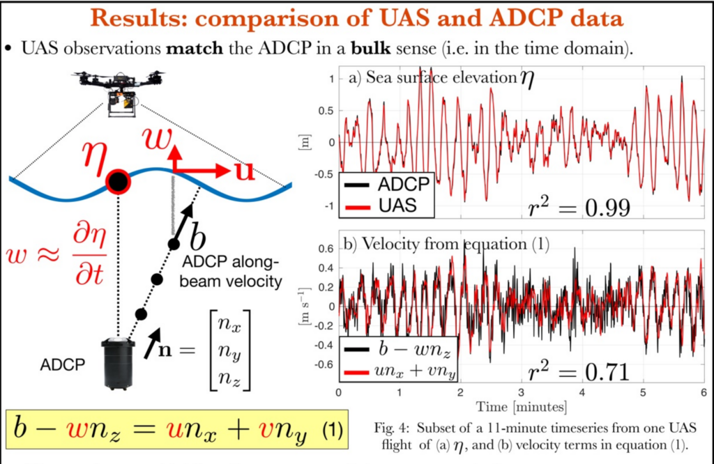
Direct comparisons of the SVS to standard ADCP observations have shown it accurately measures surface water flow and elevation, as shown in this example: measurements of waves seaward of the break point (from Marques et al., Ocean Sciences Meeting 2026):
Because the SVS uses LIDAR to map the 3D environment, it can measure water flow and motion from arbitrary vantage points, and on a 3D moving water surface. A ground-based SVS imaging system was developed for shoreline deployments, the next example shows it deployed from a small tripod to measure swash zone motion, as part of a study of cobble beach dynamics:
In the example (above), the upper three images show the camera view perspective; the lower images show the resulting 3D water flow after projecting onto a world coordinate reference frame.
The ground-based SVS system was used extensively in the STONE experiment (Sediment Transport over the Nearshore Environment, US Coastal Research Program), where it was deployed from the ceiling of the US Army Corps of Engineers Coastal Hydraulics Lab wave flume as part of research on breaking wave dynamics and the related sediment transport:
The Surface Velocity Scanner (SVS) continues to be developed as a rapidly deployable, quantitative flow imaging system. Current research efforts include expanding its applications to other flow environments and deployment methods.
