Erosion control guidebook: fellowship outcomes and final thoughts

As 2021 winds down, my fellowship is also coming to a close. It has been a wonderful and challenging experience. I wasn’t lucky enough to make it back into the office to meet coworkers in person this year, but I got to work with and learn from lots of awesome people virtually. My mentor, Meg Reed, is fantastic and was absolutely crucial in helping me succeed in this fellowship.

My main project for my fellowship was the creation of an erosion control guidebook. I spent the majority of the year reading, researching, and writing about erosion control and its regulation in Oregon. The main topics of the guidebook included:

  • Physical setting of the Oregon coast: My goal was for the guidebook to introduce anyone unfamiliar with the Oregon coast to the basics, including wave climate, sea level rise, and the impacts of El Nino and La Nina events on the coast
  • Coastal Policies: The guidebook covers the 1967 Beach Bill, which designated Oregon’s beaches as belonging to the public in perpetuity, and the coastal land use planning goals (Goal 16, 17, and 18). Goal 18 contains the most detail because its requirements are the most related to coastal erosion and beachfront protection.
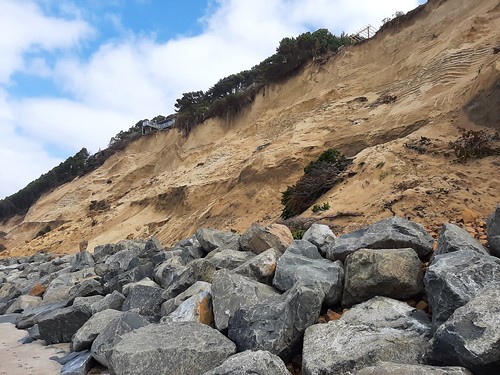
  • Beachfront Protective Structures: The guidebook discusses the impact of beachfront protective structures on the Oregon coast. It also discusses why a specific definition for a beachfront protective structure is needed, and provides the definition.
  • Permitting: The guidebook lists the agencies typically involved in permitting erosion control projects, and discusses their jurisdictions. The entire permitting process is explained, including typical permitting timelines, permit requirements, and approval criteria.
  • Types of erosion control: The guidebook divides erosion control mechanisms that are viable on the Oregon coast into two categories: nonstructural and structural. Nonstructural mechanisms include vegetative stabilization, dynamic revetments, beach scraping, and beach nourishment. Structural mechanisms include seawalls, riprap revetments, sandbags, and gabion structures. For each erosion control mechanism, the guidebook provides a literature review of the erosion control mechanism, its applicability to and use on the Oregon coast, and its usefulness in responding to sea level rise impacts.

I had the chance to do a series of 5 presentations in October and November to let people know that the guidebook existed; the most exciting and formal of these was to the Land Conservation and Development Commission. I also spent time learning Adobe InDesign so that I could present the guidebook information in a more visually appealing way.

I’m really proud of the work that I’ve done for this fellowship and of the final guidebook. However, this year has been tough. I’ve been fighting burnout and struggling with working from home. At the outset of my fellowship, I imagined myself finishing this fellowship as a super-productive master writer and communicator that had tackled several side projects in addition to my main fellowship project. I’ve had to come to terms with the fact that that vision was both partially unrealistic and partially not possible due to the challenges of working through a pandemic. But I’ve learned other things from a challenging year of work. Stephanie and Sarah reminded me at the halfway point of my fellowship that part of the skillset I spent this year learning was resilience and the ability to advocate for myself in challenging situations.

Here are a few other non work-related things I’ve learned this year:

  • Regular check-ins helped mitigate the dread Imposter Syndrome. At the halfway point of my fellowship, I was beginning to feel like I wasn’t meeting expectations and that my inadequacy would be found out at any second. However, after a halfway point check-in with my mentor, I found out that she had a good understanding of my progress and was happy with it. This shifted my perspective and allowed me to approach the second half of my fellowship from a place of confidence rather than fear.
  • I learned how to plan and execute a longer-term project. For this project, I created a work plan, reevaluated it on a regular basis, and included review deadlines for outside parties to keep myself on track.
  • I learned strategies to help myself push through periods of low motivation, including changing my workspace, using the Pomodoro technique to break work down into smaller chunks, and figuring out what activities allowed my brain to rest and recharge.

I’m excited to take what I’ve learned this year and bring it into my next job: a PhD in coastal engineering at OSU beginning in March 2022. I’ll be studying dynamic revetments, which are one of the erosion control practices I wrote about in the guidebook. I’ll get to do fieldwork on the Oregon coast and outreach with the practitioners who work there. I’m excited to continue exploring the issue of erosion control from the academic perspective and to continue working with the awesome people I’ve met over the course of this fellowship.

A reflection on my intentions for this fellowship

Fellowship Update

As I’ve talked about in past blog posts, I’m working on an erosion control guidebook that will give planners and other interested parties an overview of erosion control policy and implementation on the Oregon coast. This month, I completed a first draft of the guidebook. It was exciting to see the research I’ve been doing come together into a real document with good structure and flow. I’m also looking forward to the chance to promote my project in a series of presentations in late October and November. I’ll save the outcomes of my project for my next blog post, but I wanted to talk in this one about my goals coming into this fellowship and some of the things I’ve learned from it.

Intentions for this fellowship

I was initially excited about this fellowship because it would allow me to apply my coastal engineering masters degree in a completely new context. At the end of my masters, I had begun to realize that creative and clever engineering couldn’t provide a ‘silver bullet’ solution for the challenges posed by sea level rise and that policy, economic, and that other kinds of solutions were also needed. I was interested to see how my specific area of focus (coastal engineering) could fit into a larger view of coastal solutions, and this fellowship seemed like the perfect opportunity.

There are three main sectors I have in mind when talking about the multidisciplinary teams working to solve coastal issues. Obviously, there are many more areas of expertise that could be included, but these are the three that I feel are the most closely related to my continuing career:

  • Scientific: Scientists are instrumental in studying and understanding the challenges that impact coastal communities. Academic institutions or scientific agencies like DOGAMI have the ability to study problems and their potential solutions and contribute to a greater understanding of the coastal environment. They can also study the effectiveness of potential solutions. However, scientists have to be careful that their work is useful outside the scientific world and can be used by other practitioners
  • Policy: Policy-makers are able to use federal, state, and local laws to guide the development and conservation of the coast. Policy-makers have the important role of taking scientific knowledge and working with governing bodies and the community to come up with the best possible outcomes for coastal environments and people. Policy-makers can help coordinate between coastal issues and a huge range of other interests in a community, from economic to transportation to safety and much more. However, sometimes policy-makers don’t have the specific subject expertise for policies they are considering or are forced to rely on scientific information not suited for direct application in policy. Policy changes can also occur over a much longer time scale than scientific research and engineering.
  • Engineering: Engineers have the role of applying scientific information, policy restrictions, and individual site conditions to design creative and safe solutions to solve the solutions coastal communities are facing. Engineers bring valuable experience and practical knowledge of construction. However, they can be limited by funding (needing to use a less ideal, but cheaper solution). Engineering also sometimes acts as a “band-aid” solution without fixing the cause of the problem.

The coast is important to me, and I want to protect it in the best way I can from the threats of sea level rise and overdevelopment. I feel that communication and collaboration between these three disciplines is crucial to managing current and future coastal challenges, and I want to contribute to this by working at the intersections of them. I’ve interned for coastal engineering consulting firms (engineering sector), gotten my Master’s in coastal engineering from Oregon State University (science sector), and am now working on this erosion control guidebook with DLCD (policy sector).

Waldport
Golden hour in Waldport, August 2021. (Pictures included here not because they’re directly related to the post, but because what would a blog post about working on the coast be without some beautiful pictures of the beach?)

Experience in the policy sector

After 9 months of my fellowship, I can identify a few things I’ve learned about the intersections between engineering, policy, and science:

  • As part of my project, I’ve been writing about different kinds of erosion control for an audience of policy-makers and planners. I’ve enjoyed getting to use my expertise with reading coastal engineering academic papers to make the information more easily accessible for people in the policy realm who aren’t as familiar with engineering literature.
  • During my internships at coastal engineering firms, I often had to quickly learn all about the history of an area of the coast. Searching for relevant project reports in the area took time and resources for me as an intern, so I am trying to use my guidebook to collect as many resources in one place as I can for anyone involved with the Oregon coast to use.
  • I’ve learned a lot about the process of coastal policy-making in Oregon, especially around the subject of erosion control. After observing the Goal 18 exception processes and using recommendations from a public focus group to guide my project, I feel much more confident in participating in public processes like these, both from a professional and personal perspective.
  • Through observing public processes, I better understand how scientific and engineering information is leveraged in a policy context. The most useful information was presented with conclusions that were clear and understandable to people without any experience on the science/engineering of the issue. For example, rating systems like DOGAMI’s erosion hazard zones were useful for policy-makers because they were simple, created by scientists, and enabled policy responses to vary based on clearly delineated hazard zones.
  • By learning about the history of development on the Oregon coast, I understand why policy today is restrictive about coastal development and erosion control. While I sometimes personally wish that policies were more restrictive in some cases and less restrictive in others, understanding the history behind their development helps me appreciate their value in protecting different aspects of the coast.
  • Funding for projects is difficult to come by for state agencies, especially when they are often responsible for the upkeep and updating of basic tools rather than the flashier projects preferred by funding organizations. Collaboration between state agencies and scientists could be beneficial in securing grants.

I am confident that, whatever my next job, this fellowship will have prepared me to better connect the worlds of science, engineering, and policy. The coastal issues facing us in the near future will be complicated and will affect all aspects of coastal society, and I hope that this experience will position me to be a valuable member of multidisciplinary teams.

Newport
Newport Jetty, September 2020

Erosion control: Which methods for which situations?

In my last blog post, I talked about Goal 18 and the regulation of erosion control structures on the Oregon coast. For this post, I will provide some more details on the typical erosion control mechanisms used in Oregon. As I started writing, I thought it would be useful to present these in the context of a flow chart to show what erosion control mechanisms are appropriate in various situations. The flowchart is below and has notes for further explanation. Note that this flowchart is not official or comprehensive, but just a format I find useful to visualize the connection between site and regulatory conditions and the most common erosion control mechanisms in Oregon. For better quality, click on the image. Enjoy!

erosion control flow chart_2-final
  1. Only properties that were developed as of January 1, 1977 are eligible for structural erosion control under Goal 18.
  2. Structural erosion control, or a beachfront protective structure (BPS), is unofficially defined by DLCD as “A static structure that is intended to remain in a fixed position with the purpose of redirecting wave energy and to minimize or eliminate coastal erosion risk to development. BPS are purposefully constructed and intended to maintain that form over time. This includes, but is not limited to, rip-rap revetments, seawalls groins, breakwaters, jetties, bulkheads, geotextile sandbags, sand burritos, gabions, and concrete or mortar reinforcement such as shotcrete. Beachfront protective structures do not include dynamic treatments such as sand nourishment, cobble revetments, and similar non-structural or non-fixed erosion mitigation measures.”
  3. Even if properties are eligible for structural erosion control, Oregon Parks and Recreation Department (OPRD) will only permit them if the permit application provides an analysis of why other methods to mitigate the hazard will not work. OPRD also evaluates permit applications on the degree to which they are compatible with the surrounding environment, which means generally that structural erosion control mechanisms will not be considered until the applicant has proven that nature-based nonstructural erosion control options are not viable.
  4. Vegetated soil burritos are an alternative to riprap in some places on the Oregon coast. While not as resilient as riprap, there are two vegetative stabilization projects in Cannon Beach that have been effective in mitigating erosion. Stabilizing the bluff front with native vegetation rather than riprap has better scenic value and is less harmful to the ocean shore. Because the biodegradable fabric used to do the initial stabilization is expected to disappear as the plants establish themselves, this method is considered a non-structural form of erosion control.
  5. Some erosion control methods don’t work well for small single-home lots, and can only work when they are applied over a large area.
  6. OPRD permitting criteria includes the requirement that the erosion control structure blend in with its surroundings. Some erosion control structures, like dynamic revetments, are only appropriate on beaches where their construction material (cobbles) already exist to some extent on the beach.
  7. Dynamic revetments are artificially constructed cobble berms. The cobbles provide protection and absorb wave energy as the berm reshapes in response to wave conditions. Dynamic revetments tend to be cheaper and more easily constructible alternatives to traditional riprap; however, they do need to be maintained over time. Because dynamic revetments can change shape in response to wave conditions, they are not considered structural erosion control.
  8. Beach nourishments are a widely used and effective erosion control option in many places in the world, but Oregon’s conditions make beach nourishment difficult and costly. However, there is one example of a beach nourishment project on the Oregon coast that could be used as an example. The Army Corps of Engineers uses sand collected during dredging of the Columbia River to nourish the beaches around the jetties. This is possible because of the scale of dredge operations, the compatibility of the removed sand to the shoreface, and Army Corps resources for navigating the complex permitting environment. Because of the high-energy wave climate in Oregon and lack of suitable sand, beach nourishment is only viable under specific conditions.
  9. If you’ve gotten to this point in the flow chart, most of the options for controlling erosion have been exhausted. However, there are a few other strategies that could mitigate the effects of erosion and subsequent flooding.
  10. While it is not common on the Oregon coast, elevating homes can provide some relief from properties subject to regular flooding due to wave overtopping. FEMA has a multitude of resources on the process of home elevation.
  11. In cases where the house is in danger of toppling off a bluff, the house can be moved back on the lot. This has been successfully done in Oregon for a house in Coos Bay – the story can be found here. There have been others in the past, as well.
  12. Riprap is the most widely used erosion control structure on the Oregon coast. It is made of large boulders carefully fitted together and embedded in the sand. Riprap has been tried, tested, and proven in the high-energy wave environment of the Oregon coast. However, by fixing the shoreline in place and reflecting wave energy, riprap causes the beach to narrow as sea level rises, limiting north-south beach access. Riprap structures are intended to remain in place for a long period of time to protect bluffs and berms against erosion; therefore, they are considered structures and only allowed on Goal 18-eligible properties.

If none of these options are suitable for a property, and riprap is considered the only solution for a property not eligible for structural protection, a Goal 18 exception must be pursued. This process is currently in the public hearing phase in both Lincoln County and Tillamook County. More information can be found on their respective planning commission websites.

This flowchart is a simple way of visualizing this information; however, these erosion control mechanisms have endless variations and combinations possible to fit site conditions. Hopefully, this provides some context for the reasons why different projects might be selected for different places on the Oregon coast.

Erosion Control on the Oregon Coast

Hi! My name is Hailey, and I am one of the new Natural Resource Policy Fellows. My fellowship is with the Oregon Coastal Management Program, which is administered by the Department of Land Conservation and Development. My entire education has been in engineering (I recently finished my Master’s degree in coastal engineering at OSU), but I’m excited to dip my toes into the policy world and make connections between the two fields.

Goal 18 is one of Oregon’s land use planning goals, and it governs the beaches and dunes of the Oregon coast. It limits the construction of hard, protective structures (riprap is the most common example on the OR coast), prevents excessive dune grading, and makes sure development does not occur on beaches or active dunes. The provisions of Goal 18 are relatively simple, but can be difficult to implement. For example, the goal doesn’t contain an explicit definition of “beachfront protective structures,” which are prohibited on properties developed after January 1, 1977. As engineers and scientists continue to study innovative strategies for erosion control, it is becoming less clear which erosion control options fall under the category of “beachfront protective structures.” This lack of clarity on what constitutes a structure is just one example of the need for more guidance on erosion control. For my fellowship, I’ll aim to close this knowledge gap by developing a comprehensive guidebook on Oregon coast erosion control practices for planners, engineers, homeowners, and any other interested parties.

20210113_100257
Riprap in Neskowin.

Part of the reasoning for the limitation on beachfront protective structures in Goal 18 dates back to the 1967 Beach Bill, which provided the public with uninterrupted access to Oregon beaches. The challenge of enforcing this bill is that the location of the beach can change through erosion or accretion without regard to tax lots, private property rights, and other human boundaries. The public is therefore granted an easement onto private property if that property extends onto the beach. This means that while portions of the beach can still be owned by private property owners, the public has a right to use them.

This system works well enough when changes in the location of the beach are small. But the situation becomes direr when erosion creeps towards homes, sewer systems, and other infrastructure. Naturally, property owners turn to engineering solutions like riprap or seawalls to stop the erosion and protect their home. However, these solutions can be problematic. Hard structures that fix the shoreline in place cause the beach in front of the structure to lower and trap sand from entering the beach system. As sea level rises, water levels will reach farther onto the beach, leading to reduced or no beach access over time.

For this reason, 10 years after the passage of the beach bill, Goal 18 included a provision to preserve the beach for the public by preventing the construction of beachfront protective structures and the subsequent reduction in beach width. However, any private development built before the goal was implemented was considered exempt from this rule. Goal 18 is short (only 5 pages, linked here), but has significant impacts because it determines what coastal development can be structurally protected from erosion.

It’s important to note that erosion is not inherently a bad thing. Erosion and accretion of the coast are completely natural processes that are caused by a huge range of factors including long-term weather patterns, creek migration, individual storms, and jetty construction. However, building as close to the beach as possible sets the dynamic nature of the coast in direct conflict with the protection of development.

This winter’s storms and associated erosion threatened coastal infrastructure in a few hotspots on the coast. While the storms didn’t have unusually high wave heights, they were long period (high energy) waves, and occurred during one of the highest tides of the year.

There were several hotspots of significant erosion. On the Salishan spit, a rip embayment caused the collapse of some old riprap, leaving houses unprotected. It was only through quick action by contractors and an emergency permit from the Oregon Parks and Recreation Department (OPRD) that the houses were saved.

20210330_SalishanSpit1
Looking south from the top of the emergency riprap on the Salishan spit. Rock from the failed riprap is visible on the sand, and the extent of the erosion is visible under the house on the left.

In Gleneden beach, a large landslide is threatening homes. Some homeowners have installed riprap at the toe (bottom) of the landslide to prevent further sliding.

20210330_GlenedenLandslide5
Rocks at the base of a landslide in Gleneden Beach. Part of a deck can be seen hanging over the edge at the top left of the photo.

In Lincoln Beach, another rip embayment caused the collapse of a retaining wall structure in front of a house. This property is not eligible for riprap according to Goal 18 rules, and erosion was significant enough to threaten the house. More information is available about this situation in an article by the Newport News times (here). The homeowners, the county, and OPRD have agreed to install a temporary support beam under the house for protection while debris is cleaned up, and to protect the house while the homeowners pursue an exception to their Goal 18 ineligibility. That local goal exception process is a public process that will ultimately be decided by Lincoln County’s Board of County Commissioners.

20210330_GrantHouse1
Support beam protecting the Lincoln Avenue house from damage due to erosion.

After a very erosive winter, erosion mitigation and Goal 18 are hot topics on the Oregon coast. My project feels exciting and timely, and I hope my final product will be useful in addressing some of these challenges on the coast. In a time when all my work is remote and I haven’t met anyone I’m working with in person, it is especially meaningful to see the relevance of my work. I’m looking forward to providing updates on my project and developments on the coast throughout the rest of my fellowship.

mypic
Me at the Oregon Dunes National recreation area.