
2022 – 2024
Arctic rivers drain ~20% of global landscapes. Recent remote sensing work has improved our understanding of water discharge from arctic rivers, but sediment fluxes remain poorly constrained. Arctic rivers are difficult to study because seasonal ice cover limits wintertime access, and spring “breakup” brings hazardous ice conditions when the ice pack fractures and large blocks flow downstream. (Large rafts of ice blocks often form and create ice-jam floods, which present a further hazard.)
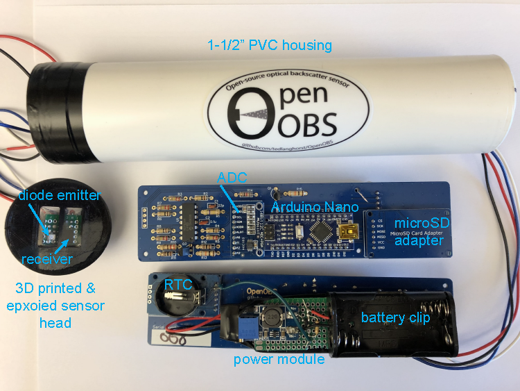
Advances in low-cost sensor technology may facilitate data collection in remote arctic rivers during all seasons. We recently developed low-cost optical backscatter sensors (OBSs) – also sometimes referred to as turbidity sensors – in a project led by Theodore Langhorst (UNC). These sensors can be constructed for ~5% the cost of commercial sensors and can be adapted for different applications, making them an attractive option for remote deployments in harsh environments where some sensors may not be recoverable.
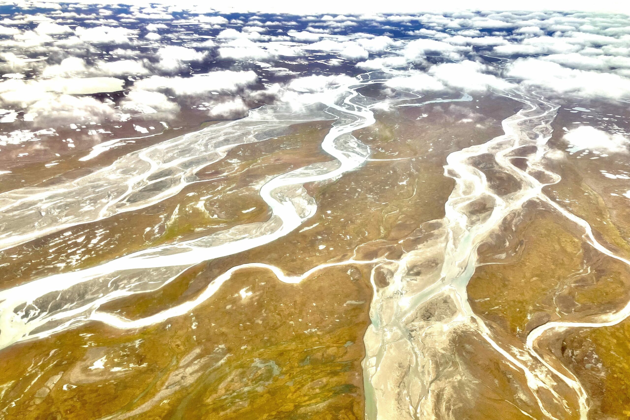
In this project, we deployed these low-cost sensors on river moorings along a 100-km stretch of the Tanana River in Alaska. Our goals were two-fold: (1) demonstrate that we could deploy and maintain these sensors over a 12-month period, i.e., during four very different seasons (summer, freezeup, winter/ice cover, and breakup) and (2) quantify sediment flux flowing through the river year-round. We selected 8 sites between Fairbanks and Nenana. This section of the river varies between a single thread and a complex braided system. Water levels are sensitive summertime inputs from melting snow and glacial ice in the nearby Alaska Range and Wrangell Mountains.
The Tanana River is a tributary of the Yukon and helps transport sediment from periglacial regions of interior Alaska toward the Bering Sea. At the town of Nenana, a tripod is constructed on the river each year, and residents can bet on the date and time of ice breakup. This novel contest (Nenana Ice Classic) has provided one of the longest climate records in Alaska.


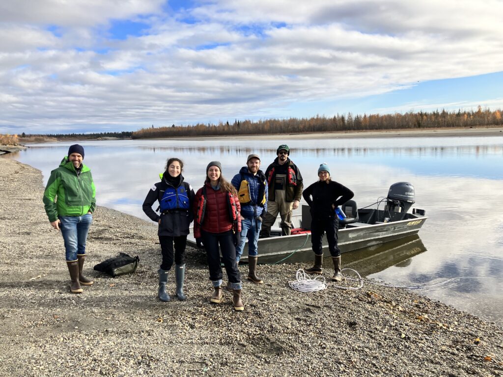
Our field campaign between October 2022 and July 2024 was generally a success. We lost some sensors, but we also recovered data year-round between fall 2022 and fall 2023, and recovered data from a larger number of sensors between fall 2023 and winter 2024. Data was relayed by iridium sensors and routed to a website where we were able to monitor conditions with a lag time of just a few hours (which was designed to conserve battery during the long, dark winter). Sensors that were lost fell victim to log snags, beavers, voles, and floods (maintaining sensors year-round is challenging!). We have our eyes on future installations which would include more fixed riverbank infrastructure and more adaptable subaqueous mounting systems.
The project was integrated with a large outreach component led by Dr. Katie Spellman and Dr. Sarah Clement at UAF. The team worked with middle schoolers at the Nenana Boarding School and Cyber Lynx homeschool network in the greater Fairbanks area. Students had the opportunity to write their “Silt stories” about interactions with the rivers and with silt. They made hypothesis about sediment concentrations in the river, helped assemble OpenOBSs, and helped deploy them in the river through the ice in winter. We reviewed the data with students two months later and discussed their findings, which included observations of sediment, frazil ice, and even black fly larvae attached to the sensors! Then students became drone pilots and were given a design challenge to create an OpenOBS mount for drone attachment. Students had the opportunity to test their mounts by flying small drones outside and dipping sensors in buckets to replicate river sampling. Sarah published a nice paper about this work with more details on lesson planning and outcomes (Clement et al., 2024).
Julianne is leading the modeling portion of the study, which involves creating a 2D model of our chosen river reach and simulating the year-round flow of sediment. We are leveraging the new in situ data to validate the model in an effort to expand on existing summertime estimates of sediment fluxes through Arctic and sub-Arctic rivers.
Project team:
- Dr. Emily Eidam (OSU), project lead
- Theodore Langhorst (UNC/Ohio State), PhD student and now postdoc; instrument development and deployment
- Julianne Davis (UNC), PhD candidate; hydrologic and sediment transport modeling
- Dr. Tamlin Pavelsky (UNC), co-PI; hydrologic data collection and modeling coordination
- Sarah Clement (UAF), PhD student; education outreach and coordination with field sampling
- Dr. Katie Spellman (UAF), co-PI; education outreach and coordination with field sampling
- Dr. Chris Arp (UAF), co-PI; field deployments and outreach coordination
- Allen Bondurant (UAF), field deployments and outreach coordination

Project papers
Arp, C., Bondurant, A.C., Clement, S., Eidam, E., Langhorst, T., Pavelsky, T.M., Davis, J., Spellman, V. 2024. Observations of high sediment concentrations entrained in jumble river ice. River Research and Applications.
Clement, S., Spellman, K., Eidam, E., Langhorst, T., Arp, C., Davis, J., Pavelsky, T., Bondurant, A. 2024. How do you sample a frozen river? Increasing K-12 STEM engagement through real-world problem solving and scientific research. Connected Science Learning.
Langhorst, T., Pavelsky, T., Eidam, E., Cooper, C., Davis, J., Spellman, K., Clement, S., Arp, C., Bondurant, A., Friedmann, E., Gleason, C. 2023. Increased scale and accessibility of sediment transport research in rivers through practical, open-source turbidity and depth sensors. Nature Water.
———————————
This project is funded by NSF grant ANS/GLD 2153778