
2020-2027
ICESat-2 is a satellite which was launched by NASA in 2018 to measure ice sheet surface elevations (and tree canopy heights) using the ATLAS instrument. ATLAS is effectively a space-based lidar sensor which uses six green laser beams (three pairs of weak/strong beams) to transmit photons, some of which are reflected from earth’s surface and geolocated.
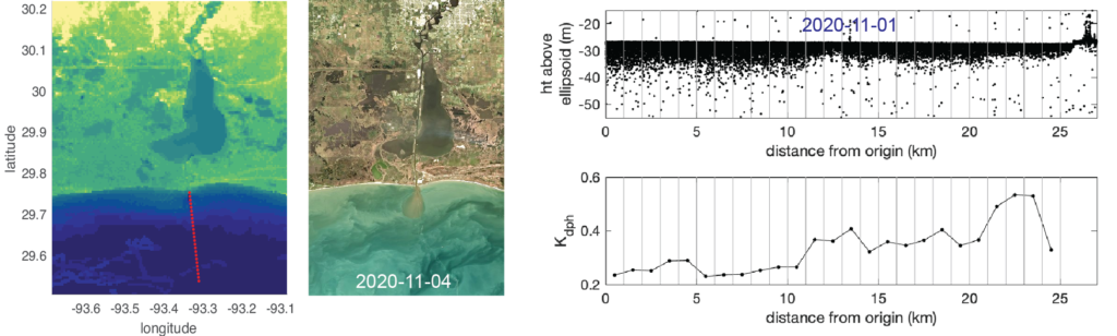
Photon returns are sometimes detectable in waters up to 40 m deep, depending on the water clarity and other environmental conditions. Several studies have assessed the utility of ATLAS data for measuring coastal bathymetry. An additional interesting product is the photon return from the water column itself; these returns are attenuated through both absorption and scattering (e.g., off of sediment particles), much in the same way that natural sunlight or constituents like photosynthetically active radiation (PAR) are attenuated.
We are conducting a study to evaluate how well ATLAS photon returns can represent suspended-sediment concentrations in surface waters and suspended-sediment inventories throughout the water column. Collaborators include Dr. Catherine Walker at WHOI, Dr. Kelsey Bisson at OSU, and Dr. Chao Wang at UNC.
Phase 1 of our calibration/validation project addressed the methods needed convert ATL03 photon xyz data from coastal regions into clean water-colunn attenuation values (Kd_photon; see Eidam et al., 2024, RSE).
Phase 2 of our calibration/validation project involves collecting in situ field data and filtering regional data repositories for additional in situ data that we can use to calibrate our Kd_photon estimates.
Our applications project involves modularizing our code for calculating Kd_photon and scaling it up to accommodate global batch-processing. Our objective is to create a global coastal Kd_photon dataset suitable for applied users who want to explore ocean processes without needing to fully learn the details of ATL data products.
Project publications:
Eidam, E.F., Bisson, K., Wang, C., Walker, C., Gibbons, A. 2024. ICESat-2 and ocean particulates: A roadmap for calculating Kd from space-based lidar photon profiles. Remote Sensing of the Environment.
Eidam, E.F., Bisson, K., Wang, C., Walker, C., 2024. Applications of space-based lidar to particle detection in the coastal ocean. Ocean Sciences Meeting, New Orleans, February.