
2019 – 2024
Some of the highest rates of coastal erosion worldwide occur in the Arctic where permafrost-rich bluffs meet the ocean. While erosion rates are fairly well-constrained, little is known about the fate of sediments released from eroding arctic bluffs after they enter the coastal ocean. In temperate systems, waves and currents serve to transport sediments along and across the continental shelf. In the Arctic, these processes are complicated by seasonal sea ice cover (for up to nine months per year). This project focuses on subtidal sediment dynamics – where are sediments sourced from bluffs and rivers transported on the continental shelf, and what are the primary forcing mechanisms?
This work is timely because arctic sea states are increasing, meaning that more wave energy is available to mobilize sediments in the present than in the past. Sediments can carry nutrients and also pollutants, and understanding how they are re-distributed in the ocean — and how those rates of transport are changing — is important to managing arctic environmental systems and protecting infrastructure.


To answer our research questions, we conducted a combined observation and modeling study of modern to millennial-timescale sediment dynamics. Observations conducted in 2021-2022 included measurements of bathymetry (multibeam mapping), mooring deployments (to measure hydrodynamics and sediment transport), seabed measurements (grab samples and cores), geotechnical and subsurface characterizations (free-fall cone penetrometer tests and CHIRP measurements, led by the Virginia Tech team), and modeling (led by Jaap Nienhuis at Utrecht).


We also teamed up with the CODA project team (led by Dr. Jim Thomson at UW) to collect some preliminary measurements during their 2019-2020 cruises. These valuable seed datasets guided our primary surveys and also helped us evaluate sediment dynamics at Blossom Shoals near Icy Cape. In that system, we learned that while the sand shoals experience active sediment transport (evidenced by the “healing” of ice scours on a seasonal basis), the shoals have been relatively stable over the past 70 years (see Eidam et al., 2024, JGR-ES).


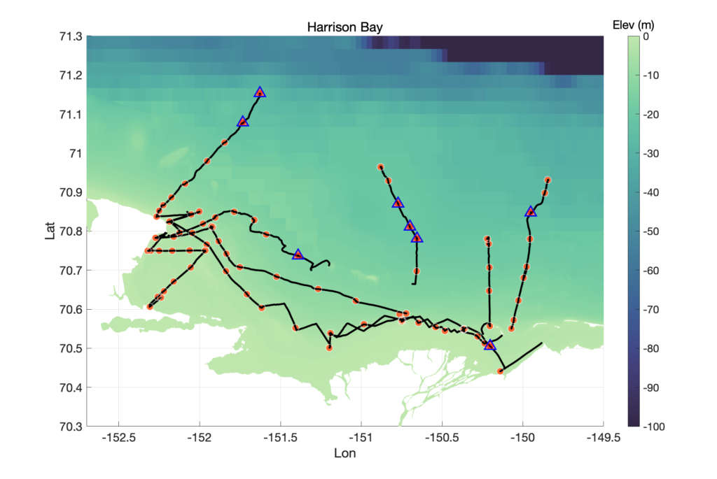
We have learned a great deal about sediment transport processes and morphology across Harrison Bay. The seabed is characterized by interesting features including large shoals, sand waves, ripples, keel scours, strudel scours, and regions of hard-packed substrate (these appear to be compacted but unfrozen muds). There are even blocks of eroded peats in some nearshore areas.

Sediment transport is strongly forced by winds, which establish Ekman transport on the middle to outer shelf and facilitate strong convergence of sediment on the middle shelf. This transport pattern resembles sediment dynamic which have been observed on the much wider Laptev Sea shelf (see Wegner et al., 2015; references can be found in the Eidam et al., 2025 Annual Reviews paper).

PhD grad Nick Brilli (VT) collected geotechnical measurements using a BlueDrop (free-fall cone penetrometer). By pairing these with data on sediment strengths measured using a jet test on cores, Nick was able to create a general classification scheme for geotechnical properties of sediments in this bay. This was not an easy task given the diversity of sediment textures created by sea ice scouring (ice keel scouring).
MS grad Adrian Heath (OSU) conducted Pb-210 analyses on sediment cores and also did a bathymetric comparison of our new multibeam data with recently corrected NOAA bathymetric charts from the 1950s (see Zimmerman et al., 2022, Cont. Shelf Res.). Adrian found that the inner shelf is strongly erosional, which was predicted conceptually by E. Reimnitz (USGS) in the 1980s. Reimnitz inferred that the shelf should retreat in a self-similar fashion following rapid shoreline retreat, causing high rates of erosion on the inner shelf where the shelf profile is concave-upward. Adrian was able to demonstrate this process occuring over a 70-year timespan using the bathymetric comparison. Magnitudes of inner-shelf erosion were up to 3 m over that period. Erosion magnitudes tapered to 0 meters on the middle shelf. Cores from the middle shelf yielded vertical Pb-210 profiles and low isotope activities, which are indicative of erosion and/or modern sediment bypass – evidence which validates the bathymetric data comparison, and has abundant implications for the transfer of sediments and associated nutrients from the coastline and rivers. These sediments are likely transported to the outer shelf or beyond, at least over timescales of decades.

On the modeling side, John Malito, Caroline Cooper, and Jaap Nienuis led the development of a model Arctic shelf (John) and model Arctic delta (Caroline) to assess sediment dynamics over the 1000-year timescale. John focused on assessing how the continental shelf may evolve in response to a change from seasonal ice cover to year-round open water conditions with a stronger wave climate (Malito et al., 2022). Caroline focused on building an arctic delta under seasonal sea-ice conditions, and then allowing the delta to evolve under diminishing sea ice and increasing wave climate. She found that sea ice, even in the absence of strong wave energy, can force a delta to adopt a compound morphology that is typical of lower-latitude systems where strong wave energy is present. The evolution of the delta under future conditions was sensitive to the balance between a longer open-water season and more energetic wave climate (Cooper et al., accepted). It seems likely that in the future, Arctic deltas like the Colville may lose their compound morphology and evolve into single clinoforms.
This project included an outreach component based in Kaktovik, Alaska. We teamed up with Dr. Jim Thomson (UW-APL), Dr. Maddie Smith (WHOI), and Lloyd Pikok, Jr. (UIC Science) to develop a middle-school and high-school educational unit about coastal oceanography. This was largely an interactive unit; students helped us assemble and program drifters (Garmin dog collars inside Nalgene bottles) and miniature moorings (Hobo temp/light sensors on a line with an anchor and float). Because of the pandemic we had only a limited opportunity for field deployments, but we had good classroom sessions on instrument assembly and software programming. Lesson plans are published at https://serc.carleton.edu/teachearth/activities/281398.html

Project team
- Dr. Emily Eidam (OSU/UNC) – project lead; field coordination and observations of sediment transport dynamics
- Dr. Nina Stark (VT/UF) – co-lead; geotechnical measurements
- Dr. Jaap Nienhuis (Utrecht) – co-lead; morphodynamic modeling
- Dr. Jeff Obelcz (NRL) – collaborator
- Dan Duncan (UTIG) – research scientist, mutlibeam tech
- Dr. Nick Brilli (VT) – grad student; geotechnical characterizations
- John Malito, MS (UNC) – grad student; shelf modeling
- Caroline Cooper, MS (UNC) – grad student; delta modeling
- Adrian Heath, MS (OSU) – grad student; core radiochemistry and mapping
We have also been assisted by a host of undergraduate lab assistance who have done a stellar job with sample and data analyses!


Project papers
Brilli, N.C., Stark, N., Eidam, E., Nienhuis, J., Castro-Bolinaga, C. ACCEPTED. Assessing Variations in Sediment Properties and Erodibility in Harrison Bay, Alaska using a Portable Free-Fall Penetrometer. Journal of Cold Regions Engineering.
Cooper, C., Eidam, E., Seim, H., & Nienhuis, J. (2024). Effects of sea ice on Arctic delta evolution: A modeling study of the Colville River Delta, Alaska. Journal of Geophysical Research: Earth Surface, 129(9), e2024JF007742. https://agupubs.onlinelibrary.wiley.com/doi/full/10.1029/2024JF007742
Eidam, E.F., Stark, N., Nienhuis, J., Keogh, M., Obelcz, J. (2025). Subtidal Arctic Sediments. Annual Reviews of Marine Science. Available as an early publication: https://doi.org/10.1146/annurev-marine-040423-023827
Eidam, E.F., Thomson, J., Malito, J.G., Hošeková, L. (2024). Morphology and sediment dynamics of Blossom Shoals at Icy Cape, Alaska. JGR-Earth Surface, 129(4), e2023JF007398.
Eidam, E.F., Cooper, C., Heath, A., Nienhuis, J., Seim, H. (2024). Summertime sediment-transport dynamics on an arctic continental shelf. AGU, San Franciso. https://ui.adsabs.harvard.edu/abs/2023AGUFMOS33D1624E/abstract
Cooper, C., Eidam, E., Nienhuis, J., Seim, H. (2023). Modelling the effects of sea ice on Arctic delta morphology. Proceedings of Coastal Sediments 2023, 1354-1363.
Eidam., E., Brilli, N., Heath, A., Cooper, C., Duncan, D., Nienhuis, J., Stark, N. Morphology and sediments of the subaqueous Colville River Delta (Alaska). AGU, Chicago. https://ui.adsabs.harvard.edu/abs/2022AGUFMOS25D0953E/abstract
Malito, J., Eidam, E., & Nienhuis, J. (2022). Increasing wave energy moves Arctic continental shelves toward a new future. Journal of Geophysical Research: Oceans, 127(9), e2021JC018374.
Eidam, E., Stark, N., Nienhuis, J., Duncan, D., Brilli, N., Smith, R., Kallioras, N., Heath, A., in prep. Seafloor sediments and morphology of Harrison Bay in the Alaskan Beaufort Sea.
Project datasets
Eidam, E.F., Thomson, J., Malito, J., Hošeková, L. (2024). Blossom Shoals water-column, seabed sediment, and bathymetry data. Icy Cape, Chukchi Sea, Alaska. 2019-2020. Arctic Data Center. doi:10.18739/A2862BD1G.
Cooper, C., Eidam, E., Nienhuis, J. 1500, 500, and 450-year Sea Ice Models and Output Morphology Data, Colville River Delta, Alaska. Arctic Data Center. doi:10.18739/A2XG9FC7G.
Brilli, N., Stark, N., Eidam, E. Alaskan Beaufort Shelf Sediment Study – Harrison Bay: Geotechnical Properties from a Portable Free-Fall Penetrometer and Erodibility Assessment, 2021-2022. Arctic Data Center. doi:10.18739/A2JD4PQ9T.
Eidam, E.F. Seabed grain-size data from Harrison Bay (Beaufort Sea continental shelf), Alaska 2021. Arctic Data Center. doi:10.18739/A2JW86P50.
Eidam, E., Thomson, J., Malito, J., Hošeková, L. Blossom Shoals water-column, seabed sediment, and bathymetry data. Icy Cape, Chukchi Sea, Alaska. 2019-2020. Arctic Data Center. doi:10.18739/A2862BD1G.
Malito, J., Eidam, E., Nienhuis, J. Alaskan Beaufort Shelf Evolution Model Setup and Output Data Files. Arctic Data Center. doi:10.18739/A2H70820F.
———————————————
This project is funded by NSF grants OPP 1913195 (Eidam) and OPP 1912836 (Stark)