Coastal Hazards Resilience in Oregon

Hi! Like Hailey and Amy, I am new fellow. My name is Felicia Olmeta-Schult and I am the Resilience Fellow for Oregon Sea Grant (OSG). I am in this position since the end of January.

Before joining the OSG family, I was a Washington Sea Grant Hershman fellow with the Washington State Department of Ecology. This is where I started working on coastal hazards resilience issues. I helped improving the Washington Coastal Hazards Resilience Network (CHRN) website. I am grateful to be able to bring some of my experience to OSG and to continue to work on such an important issue. I also work on the side for Coastal News Today and the American Shoreline Podcast Network and I will have my own podcast soon!

Before describing my work at OSG, I would like to share a little more about my background. I am from Corsica, France, and I left my Mediterranean island to study oceanography in Hawaii, marine affairs in Rhode Island, and environmental and natural resource sciences in Washington. I received my PhD from Washington State University Vancouver in 2018. My dissertation investigated the North Coast of California Marine Life Protection Act Initiative by studying how Tribes and stakeholders (e.g., commercial fishermen, NGOs, recreational users) interacted and were involved during the marine protected area (MPA) planning process, and how they perceived socio-economic and ecological effects of MPAs.

As the Resilience Fellow, I work with staff at Oregon Sea Grant and other partners to increase the resilience of Oregon communities to the impacts of climate change and chronic (e.g., sea level rise, coastal erosion and flooding) and acute (e.g., earthquakes and tsunamis) coastal natural hazards .

Since the beginning of my position, I contacted and introduced myself to staff at several agencies and organizations (e.g., Oregon Department of Land Conservation and Development, Coos Watershed Association, Oregon Parks & Recreation, Oregon Partnership for Disaster Resilience, and Oregon Coast Visitors Association). This was a great way for me to have an overview of the work on coastal hazards happening at both the state and local level, and to identify potential work collaborations with these groups. I also had the opportunity to have a guided visit on the Lincoln County coast.

Jay Sennewald, with the Oregon Parks and Recreation Department (OPRD), showed me the damages of coastal erosion this past winter. If you go to Hailey Bond’s blog post, you will see more coastal erosion photos and have a very instructive background on coastal erosion control and policy in Oregon.

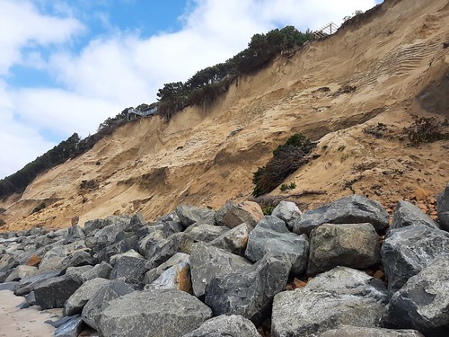
You will find below photos I took this April in the same area as Hailey in Lincoln County. I think these photos were taken a couple of months after Hailey took hers. You will notice changes at the landslide site in Gleneden Beach and on Salishan spit. This year, a total of 14 houses applied for emergency permits from the OPRD.

This brings me to my projects as a fellow. For one project, I will identify and create a list of coastal hazards mitigation and adaptation projects in Oregon. For example, one of these projects is the construction of a cobble berm and reinforced foredune to protect Cape Lookout State Park from erosion and flooding (see publication). Our goal is to create an interactive map (i.e., StoryMap) allowing users to see where these projects are localized and to learn more about them via short case studies providing information on adaptation strategies, lessons learned, partners, and grants for example. This effort will be similar to the Washington Coastal Hazards Risk Reduction Project Mapper. However, our case studies, in addition to physical projects, will also include programs, academic research, planning efforts, and local initiatives. We hope this resource will be useful to individuals, communities, and local governments to identify practical approaches to coastal hazards and learn from others facing similar issues in Oregon.

Another project I am working on involves tsunami education and preparedness for the hospitality industry. The Oregon Sea Grant Sustainable Coastal Tourism & Outdoor Recreation Program created the Practical Customer Service (PCS) Training to provide the hotel/lodging and coastal visitor-​industry with a short and free online training. In addition, on the coast, it is important to know the facts about tsunamis and how to communicate them to visitors. Therefore, this training integrates practical customer service with scientific information about tsunamis and the basic safety information we all need to know. At the end of the PCS training there is a link to the Oregon Emergency Management’s Tsunami Safe Training. For this project, we are interested in surveying hotel general managers and staff to have their feedback on the PCS and Tsunami Safe trainings. We also want to identify what hotel management cares about and needs to be successful while keeping their employees ready and resilient when a tsunami hits.

As the other OSG Scholars mentioned, it has been challenging to start a new position in the middle of a pandemic. Thanks to the vaccine, I hope that I will get to meet OSG colleagues and partners in-person soon. In the meantime, my two cats have been very happy with my remote working situation!

I will provide updates on my projects in my next blog. Do not hesitate leaving a comment below if you have any questions!

Thank you for reading!

Erosion Control on the Oregon Coast

Hi! My name is Hailey, and I am one of the new Natural Resource Policy Fellows. My fellowship is with the Oregon Coastal Management Program, which is administered by the Department of Land Conservation and Development. My entire education has been in engineering (I recently finished my Master’s degree in coastal engineering at OSU), but I’m excited to dip my toes into the policy world and make connections between the two fields.

Goal 18 is one of Oregon’s land use planning goals, and it governs the beaches and dunes of the Oregon coast. It limits the construction of hard, protective structures (riprap is the most common example on the OR coast), prevents excessive dune grading, and makes sure development does not occur on beaches or active dunes. The provisions of Goal 18 are relatively simple, but can be difficult to implement. For example, the goal doesn’t contain an explicit definition of “beachfront protective structures,” which are prohibited on properties developed after January 1, 1977. As engineers and scientists continue to study innovative strategies for erosion control, it is becoming less clear which erosion control options fall under the category of “beachfront protective structures.” This lack of clarity on what constitutes a structure is just one example of the need for more guidance on erosion control. For my fellowship, I’ll aim to close this knowledge gap by developing a comprehensive guidebook on Oregon coast erosion control practices for planners, engineers, homeowners, and any other interested parties.

20210113_100257
Riprap in Neskowin.

Part of the reasoning for the limitation on beachfront protective structures in Goal 18 dates back to the 1967 Beach Bill, which provided the public with uninterrupted access to Oregon beaches. The challenge of enforcing this bill is that the location of the beach can change through erosion or accretion without regard to tax lots, private property rights, and other human boundaries. The public is therefore granted an easement onto private property if that property extends onto the beach. This means that while portions of the beach can still be owned by private property owners, the public has a right to use them.

This system works well enough when changes in the location of the beach are small. But the situation becomes direr when erosion creeps towards homes, sewer systems, and other infrastructure. Naturally, property owners turn to engineering solutions like riprap or seawalls to stop the erosion and protect their home. However, these solutions can be problematic. Hard structures that fix the shoreline in place cause the beach in front of the structure to lower and trap sand from entering the beach system. As sea level rises, water levels will reach farther onto the beach, leading to reduced or no beach access over time.

For this reason, 10 years after the passage of the beach bill, Goal 18 included a provision to preserve the beach for the public by preventing the construction of beachfront protective structures and the subsequent reduction in beach width. However, any private development built before the goal was implemented was considered exempt from this rule. Goal 18 is short (only 5 pages, linked here), but has significant impacts because it determines what coastal development can be structurally protected from erosion.

It’s important to note that erosion is not inherently a bad thing. Erosion and accretion of the coast are completely natural processes that are caused by a huge range of factors including long-term weather patterns, creek migration, individual storms, and jetty construction. However, building as close to the beach as possible sets the dynamic nature of the coast in direct conflict with the protection of development.

This winter’s storms and associated erosion threatened coastal infrastructure in a few hotspots on the coast. While the storms didn’t have unusually high wave heights, they were long period (high energy) waves, and occurred during one of the highest tides of the year.

There were several hotspots of significant erosion. On the Salishan spit, a rip embayment caused the collapse of some old riprap, leaving houses unprotected. It was only through quick action by contractors and an emergency permit from the Oregon Parks and Recreation Department (OPRD) that the houses were saved.

20210330_SalishanSpit1
Looking south from the top of the emergency riprap on the Salishan spit. Rock from the failed riprap is visible on the sand, and the extent of the erosion is visible under the house on the left.

In Gleneden beach, a large landslide is threatening homes. Some homeowners have installed riprap at the toe (bottom) of the landslide to prevent further sliding.

20210330_GlenedenLandslide5
Rocks at the base of a landslide in Gleneden Beach. Part of a deck can be seen hanging over the edge at the top left of the photo.

In Lincoln Beach, another rip embayment caused the collapse of a retaining wall structure in front of a house. This property is not eligible for riprap according to Goal 18 rules, and erosion was significant enough to threaten the house. More information is available about this situation in an article by the Newport News times (here). The homeowners, the county, and OPRD have agreed to install a temporary support beam under the house for protection while debris is cleaned up, and to protect the house while the homeowners pursue an exception to their Goal 18 ineligibility. That local goal exception process is a public process that will ultimately be decided by Lincoln County’s Board of County Commissioners.

20210330_GrantHouse1
Support beam protecting the Lincoln Avenue house from damage due to erosion.

After a very erosive winter, erosion mitigation and Goal 18 are hot topics on the Oregon coast. My project feels exciting and timely, and I hope my final product will be useful in addressing some of these challenges on the coast. In a time when all my work is remote and I haven’t met anyone I’m working with in person, it is especially meaningful to see the relevance of my work. I’m looking forward to providing updates on my project and developments on the coast throughout the rest of my fellowship.

mypic
Me at the Oregon Dunes National recreation area.