Picture this: it’s a Thursday morning, Corvallis is clouded over and feels more like like March or October than the middle of August. With scrawled notes and poorly drawn wire frames for our new web site scattered over every surface of the Archives reference desk, we were deep in talks about the “about” page — with a few diversions into chats about our Flickr-verse and the 150,000 views milestone we are rushing towards. A professor from a neighboring university arrives to look at our Sanborn maps; she’s looking for maps of Portland from the late 19th and early 20th centuries.
“Sanborn Maps were originally created for assessing fire insurance liability in urbanized areas in the United States. The maps include detailed information regarding town and building information in approximately 12,000 U.S. towns and cities from 1867 to 1970. Author Kim Keister describes the legacy of Sanborn maps: “Stated simply, the Sanborn maps survive as a guide to American urbanization that is unrivaled by other cartography and, for that matter, by few documentary resources of any kind.” They are a highly useful resource for historical research, planning, preservation, genealogical research, sociological studies and research of urban geography.”
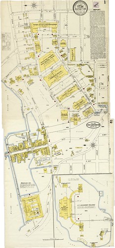
After a few false starts, like the one that took me to the usual case I would go to for Sanborn maps, we located the case with the 1897 and 1907 maps she wanted in the big map cases that also hold some of our historic maps and oversized archives. Then, and this is one of those magical archives moments, as I am opening the case I see the label: “Portland 1905, Lewis & Clark Exposition.” And what did I find? Yes, in addition to mapping the buildings in Portland at the turn of the 20th century, the Sanborn Insurance Company had also mapped the buildings of the 1905 Expo. You can view the two beautifully detailed and color coded maps here.
Take the time to zoom in…
Look for the “Infant Incubator Building,” the “Forestry Building,” the “Oriental Building.” See if you can read the names on the little shops or the big showcase buildings. And take note of the upper right corner, which gives you information about the water supply, fire department, and construction of the buildings. Also, if you are a little confused about where the Expo was located, understandable because none of these buildings still stand, click the “map” (which you’ll find under the “additional information” on the right side of the screen) to orient yourself.
And, for those concerned about our poor patron and her place in my excited frenzy that followed, she was as thrilled as we were and happily abandoned her research (temporarily) to “oooh” and “ahhh” with us! And yes, then she dutifully returned to her maps and found what she needed…


