Category Archives: Main Page

150,000 views!

For those of you keeping track, we hit 150,000 views in our Flickr Commons account this weekend! So I send out a hearty thanks to all our loyal viewers and all our new friends — we wouldn’t be here without you.

And remember, we launch new sets every first and third Wednesday and you can set up an RSS feed so you don’t miss a single thing.

What’s coming? This week we’re heading to Crater Lake, care of the Visual Instruction Department Lantern slide collection. Here’s a sneak peek for those of you who can’t wait.

After that, we’re staying with this collection, but shifting to another great series of images from Oregon Industry, circa 1905, 1925, and 1940.

The beauty of an accidental discovery…

Picture this: it’s a Thursday morning, Corvallis is clouded over and feels more like like March or October than the middle of August. With scrawled notes and poorly drawn wire frames for our new web site scattered over every surface of the Archives reference desk, we were deep in talks about the “about” page — with a few diversions into chats about our Flickr-verse and the 150,000 views milestone we are rushing towards. A professor from a neighboring university arrives to look at our Sanborn maps; she’s looking for maps of Portland from the late 19th and early 20th centuries.

“Sanborn Maps were originally created for assessing fire insurance liability in urbanized areas in the United States. The maps include detailed information regarding town and building information in approximately 12,000 U.S. towns and cities from 1867 to 1970. Author Kim Keister describes the legacy of Sanborn maps: “Stated simply, the Sanborn maps survive as a guide to American urbanization that is unrivaled by other cartography and, for that matter, by few documentary resources of any kind.” They are a highly useful resource for historical research, planning, preservation, genealogical research, sociological studies and research of urban geography.”

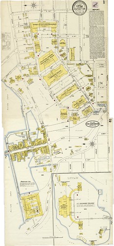
After a few false starts, like the one that took me to the usual case I would go to for Sanborn maps, we located the case with the 1897 and 1907 maps she wanted in the big map cases that also hold some of our historic maps and oversized archives. Then, and this is one of those magical archives moments, as I am opening the case I see the label: “Portland 1905, Lewis & Clark Exposition.” And what did I find? Yes, in addition to mapping the buildings in Portland at the turn of the 20th century, the Sanborn Insurance Company had also mapped the buildings of the 1905 Expo. You can view the two beautifully detailed and color coded maps here.

Take the time to zoom in…

Look for the “Infant Incubator Building,” the “Forestry Building,” the “Oriental Building.” See if you can read the names on the little shops or the big showcase buildings. And take note of the upper right corner, which gives you information about the water supply, fire department, and construction of the buildings. Also, if you are a little confused about where the Expo was located, understandable because none of these buildings still stand, click the “map” (which you’ll find under the “additional information” on the right side of the screen) to orient yourself.

And, for those concerned about our poor patron and her place in my excited frenzy that followed, she was as thrilled as we were and happily abandoned her research (temporarily) to “oooh” and “ahhh” with us! And yes, then she dutifully returned to her maps and found what she needed…

New Exhibit at LaSells Stewart Center

The OSU Archives has a lot of great images of food…

Want to see Braceros workers harvesting potatoes? A 1920s Horticulture show in the Men’s Gymnasium main floor?

And what about canning? Perhaps you are interested in a portable community cannery? Or other canning shots of women canning beans, a woman canning cheese, canned maraschino cherries?

But what if you want some contemporary images? A new exhibit, featuring the bounty of Oregon agriculture and a reflection of the role Oregon State University’s agricultural research plays in sustaining our state’s rich farming heritage opens today. After a show in the Murdoch Gallery at the LaSells Stewart Center at Oregon State University, the Savory Images photo exhibit begins a tour across the state and is available for month-long display during 2009-2010, free of charge.

Photos are by award-winning photographer Lynn Ketchum and from the pages of the acclaimed magazine Oregon’s Agricultural Progress. Check out the site for the traveling exhibit — it’s beautiful! Just make sure your stomach is full…

New to our reference shelf…

A detailed study of American public radio’s early history: Radio’s Hidden Voice: The Origins of Public Broadcasting in the United States, by Hugh Richard Slotten.

“Employing extensive research from archives across the United States, Hugh Richard Slotten examines the origins of alternative broadcasting models based especially on a commitment to providing noncommercial service for the public. These stations, operated largely by universities and colleges, offered diverse forms of programming meant not merely to entertain but also to educate, inform, enlighten, and uplift local citizens.” Want to know more?

Marcus Borg named canon theologian at Trinity Cathedral in Portland

“Marcus Borg, internationally known biblical scholar, was installed as the first canon theologian at Trinity Episcopal Cathedral in Portland, Oregon. Borg will present public lectures, teach adult courses within the parish, preach occasionally, and serve as a consultant for parish education programs.”

He holds a DPhil degree from Oxford University and is Hundere Distinguished Professor of Religion and Culture, an endowed chair, at Oregon State University.

Want to know more about the post at Trinity Episcopal Cathedral?

Want to see the collection guide for Dr. Borg’s papers at the OSU Archives?

Want to know more about Dr. Borg?

Want to read Dr. Borg’s blog for the Washingon Post?

Watch for it: tomorrow is Wednesday!

We return home this week in Flickr Commons for a much deserved “trip to Mount Hood.” Thirty-five enchanting images that let you travel from Portland’s rose gardens, through Multnomah Falls, and up to the tippy top up the Upper Glacier on the mountain. Black and white or hand-colored, these glass lantern slides are an incredible look at the past…

And, as we’ve found with other sets from the Visual Instruction Department, there was a delightful description of the images for instructors found with the set! And, as an added bonus, we also found that the description booklet included wonderful details for the individual images, which are included in the “Description/Notes” field for each image in the set. If you can tear yourself away from the images, the extra information, written in 1930s-ese, is well worth reading.

Favorites? It’s hard to choose, but make sure you linger on images of the Rose Garden, the harbor scene, Mitchell Point Tunnel, and the glaciers of Mt. Hood!