Categories
Portfolio

Upper Klamath Basin Irrigation Water Use Analysis

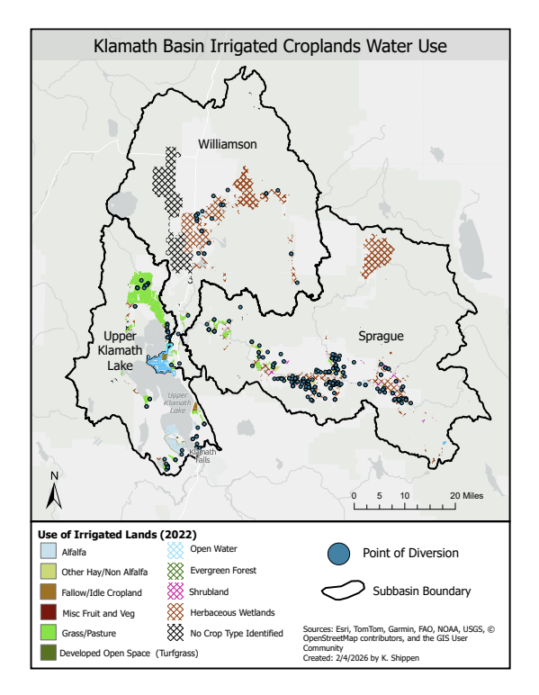
Analysis of irrigation water use by field and land cover classification types to inform water use analysis in the Upper Klamath Lake, Williamson, and Sprague sub basins. Integrated vector and raster USDA Croplands, National Agriculture Imagery Program (NAIP), NLCD, Open ET, and Desert Research Institute field boundary data in ArcGIS Pro to estimate irrigated land area extent and categorize amount of irrigation applied per land cover or crop type.

Example map layout above is one of the map deliverables produced during this analysis. The final maps were accompanied with Excel pivot tables highlighting the key statistics of intrest to that client.

Categories
Portfolio

Almeda and Obenchain Automated Fire Recovery Tracking Platform

This ArcGIS Experience Builder contains detailed statistics tracking fire recovery efforts after the 2020 Almeda and Obenchain fire that automatically refresh each time a new change is submitted and approved through the Survey123 associated with the recovery data. Feedback from users highlighted that an interactive display with data updating as the map was filtered or zoomed was helpful in guiding recovery efforts so a interactive Dashboard was embedded into the Experience Builder as well. Data source: from Jackson County GIS hub.

Full Experience Builder and interactive Dashboard can be viewed here: https://experience.arcgis.com/experience/a9165c3260a241069723322b4591622a

Categories
Portfolio

Critical Salmonid Habitat Analysis

Analysis of stream miles of critical stream habitat of NOAA, ODFW, and Department of State Lands GIS data layers to generate complete accounting for critical habitat miles within Salem UGB and within a 35 meter buffer of the Salem UGB to deliver to a client making natural resource management decisions for the Salem, Oregon area.

Categories
Portfolio

Investigating Home Equity in Affordable Homeownership Programs

A GIS-Based Real Estate Index Approach

This GIS based analysis investigates how long-term homeownership affordability tools built into affordable homeownership program structures impact participating homeowners’ opportunity to build wealth. Using county-level tax lot data and GIS analysis, this study aimed to answer questions about the impacts of affordable homeownership programs, such as shared equity programs, on the potential equity homeowners in those programs realize. Using Real Estate Index methodology combined with Tax Lot data to generate an index of single-family attached homes in Medford, Oregon, the home equity gains that homeowners in affordable housing programs realize were quantified and compared to the traditional real estate market. This research provides data-driven insights for program decision-makers to balance the dual goals of maintaining long-term housing affordability while supporting homeowner wealth accumulation.

Results of the analysis can be viewed in the experience builder linked below: https://experience.arcgis.com/experience/4d31f24d7b54433c9e66325d7c21f671