The objectives of this project are to:
- Characterize the varied ways in which floodplains are defined in the modern landscape, and why those differences matter;
- Use numerical models to evaluate how multi-scale floodplain connectivity impacts post-wildfire sediment deposition;
- Evaluate how spatial and geomorphic characteristics (e.g., underlying geology, connectivity, etc.) of floodplains can be used to target restoration actions and optimize watershed resilience benefits.
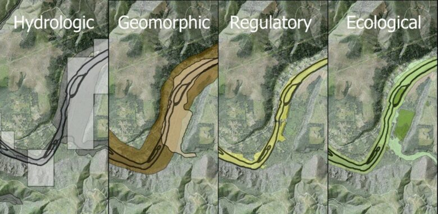
What is a modern floodplain?
The extent and benefits of floodplains to human and environmental health are vast and well documented, as are the extensive ways in which floodplains have been modified and degraded. These ways include both direct and indirect modifications, such as construction of levees that disconnect the floodplain from its river, enlarging and straightening the active channel via dredging and other means, removal of riparian vegetation and conversion of land use to agricultural and urban uses, regulation of flows by upstream dams that reduce flood magnitude and frequency, increased drainage of floodplains to facilitate agriculture, among others. These changes are widespread: In the US, the integrity of 70% of floodplains is rated as poor. Society needs a more coherent approach to understanding what a floodplain is under modern and changing conditions. We thus conducted a synthesis of peer-reviewed and policy literature, coupled with map generation, with the aims of:
- characterizing the complex landscape of how floodplains are defined,
- identifying the key themes that make the definitions complex;
- illustrating
ehow the various definitions play out in the landscape; - identifying the major functions and the criteria that describe what’s necessary for those functions to exist; and
- developing recommendations for policies and public communication about floodplains in this complex landscape.
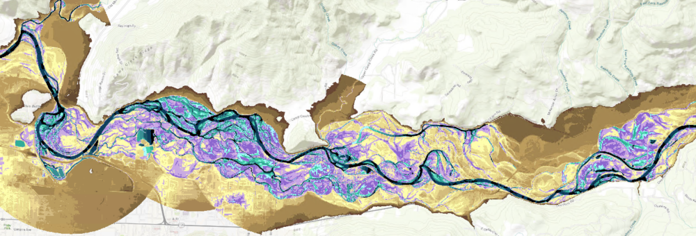
Topographic complexity and sediment deposition in floodplains
Wildfires can release large amounts of sediment into rivers, harming water quality. Climate change is increasing wildfire risks, making this problem worse. Floodplains—areas along the main channel of a river that become inundated by water during floods,—may help reduce this impact by trapping some of the sediment before it flows downstream. However, how well floodplains can store wildfire-related sediment depends on factors like the surface complexity, size, shape, how often they flood, and how much sediment is carried by the flood. This study numerical models to simulate how floodplains capture and store sediment after wildfires. Researchers are testing different floodplain configurations in terms of their surface complexity and flood conditions to see which setups work best at reducing sediment in the water. The results will help determine where restored or reconnected floodplains could be most effective in protecting water quality after wildfires. The goal is to provide practical guidance on how floodplains can be used to lessen the impact of wildfires on rivers and drinking water supplies.
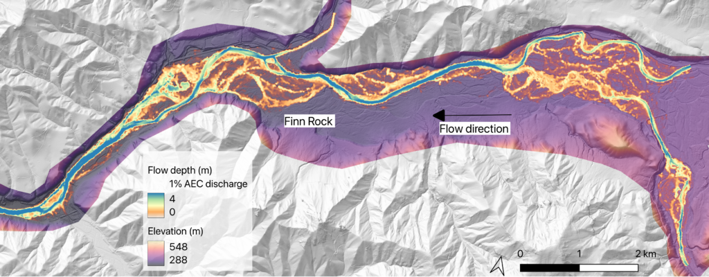
Geographic intersection of municipal watersheds and floodplain restoration opportunities
With the threat of increased sediment loads released following wildfire events, solutions for maintaining water quality post wildfire, especially in municipal watersheds that supply drinking water, are of interest and importance. Laterally connected floodplains along free-flowing rivers can increase the chance of deposition for suspended sediments during high-flow events. Thus, it is hypothesized that reconnecting floodplains may work as a nature-based engineering solution to support municipal drinking water management by mitigating the fine sediments introduced after a wildfire event. We ask the question: Can geomorphic characteristics and geographic placement of floodplains help optimize resilience actions to address sediment-related water quality degradation post-wildfire? To answer this question, we are grouping and mapping river reaches within municipal watersheds based on the reconnection potential and floodplain availability, incorporating information such as landslide susceptibility, land use, and soil type to support our characterization of these areas. We will complete the mapping and analysis at a regional scale across Oregon and Washington, focusing on surface water sources.

