Debris from Japanese tsunami slowly making its way toward West Coast

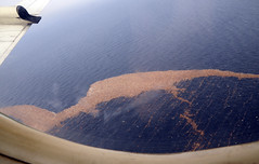
Debris from Japanese tsunami floats in Pacific in mid MarchA massive trail of debris from the devastating tsunami that struck Japan on March 11 is slowly making its way across the Pacific Ocean en route to the West Coast of the United States, where scientists are predicting it will arrive in the next two to three years – right on schedule.

The mass of debris, weighing millions of tons and forming a trail a thousand miles long, will likely strike Oregon and Washington, according to models based on winds and currents.

But new accounts of where the trail has progressed suggest that at least some of that debris may peel off and enter the infamous “Garbage Patch,” a huge gyre in the Pacific where plastic and other debris has accumulated over the years, according to Jack Barth, an Oregon State University oceanographer and an expert on Pacific Ocean currents and winds.

“Recent reports of debris are from farther south than the axis of the main ocean currents sweeping across the north Pacific toward Oregon,” said Barth, a professor in OSU’s College of Oceanic and Atmospheric Sciences. “This means a fair amount of debris may enter the patch. We should still see some of the effects in Oregon and Washington, but between some of the materials sinking, and others joining the garbage patch, it might not be as bad as was originally thought.”

Read more from OSU News & Research Communications

(Photo courtesy of  US Pacific Fleet gallery on Flickr)

Outside magazine profiles Sea Grant’s Pat Corcoran

PITY POOR CASSANDRA, blessed by Apollo with the power of prophecy, cursed with the fate of ­disbelief. She tells the people what’s coming. She suffers their laughter, absorbs their scorn. Then she watches her prediction come true. Yeah, you told us so, they’ll say as they bury the dead. Congratulations, jerk.

Patrick Corcoran feels her pain. It’s his job. Every day, he rises at dawn and goes out into the world to tell people to prepare to meet their doom. Or, rather, to prepare to escape it.

Corcoran is a professional geographer in Astoria, Oregon, a misty fishing port where the Columbia River meets the ­Pacific Ocean. He’s a high-energy guy, 50, with a little ­Billy Bob Thornton to his look. Loves his job and loves his coffee. Drives around in his ­Toyota ­Tacoma all day with an 11.5-foot-long Taka­yama paddleboard strapped to the rack. He’s a coastal natural-hazards specialist with Ore­gon Sea Grant, a marine version of an agri­cul­tural extension service affiliated with ­Oregon State University. Cor­coran prophesies earthquakes and tsunamis five days a week. …

(Read the whole article at Outside Online...)

A Tsunami on the Columbia

What might happen if a nearshore tsunami caused by a local earthquake were to travel from the Oregon coast up the Columbia River? That was the focus of a recent research workshop funded by Oregon Sea Grant at Oregon State University (OSU), August 15-16.

“We know tsunamis can penetrate along rivers for long distances,” said OSU tsunami expert Harry Yeh, the workshop organizer. But, said Yeh, tsunami penetration up rivers has been largely unexplored until now.

“In the coastal plain they [tsunamis] can penetrate 2 to 5 kilometers [about 1 to 3 miles], but with the river they can penetrate up to 10 kilometers [about 6 miles] no problem.”

The Oregon Coast lies along the Cascadia subduction zone, a fault line that stretches from Northern California to British Columbia. The Cascadia subduction zone is similar to the subduction zone that caused Japan’s recent earthquake and tsunami. A magnitude 9.0 earthquake occurs along the Cascadia subduction zone once every 300-500 years. It had its most recent earthquake in 1700. This expected earthquake would most likely be accompanied by a tsunami, which could affect the Columbia River, said Yeh.

The 18 workshop attendees were asked by Yeh to model a section of the Columbia that stretches from Astoria, Oregon at the coast all the way to the Bonneville Dam. Yeh said the idea was to gather general data that could be used in future tsunami modeling.

“We are not trying to do detailed models of say Astoria or Longview, for instance,” said Yeh.  “Though, I think that’s next step.”

Many of Oregon’s coastal communities could one day feel the affects of a tsunami. Communities that could be flooded or inundated by tsunamis have been mapped by the Oregon Department of Geology and Mineral Industries into inundation zones. But these inundation maps don’t include the Columbia, said Yeh. Instead the maps stop at Astoria, which lies at the mouth of the Columbia. The workshop’s exploration of what might happen if a Tsunami penetrated the Columbia could change how tsunami inundation maps are made in the future, said Yeh.

“This work is very theoretical, very academic, but it has direct consequences and real applications, which is why I feel like this is important work,” said Yeh.

Events at the recent workshop included presentations by Yinglong Joseph Zhang of Oregon Health and Science University on how far a tsunami could penetrate the Columbia, as well as a presentation by David Jay of Portland State University, on the hydrodynamics of the river. Workshop discussions also included comparing different tsunami modeling techniques including those used by the National Oceanic and Atmospheric Administration (NOAA) and those used by the Japanese government.

Of particular interest to Yeh himself is a stretch of the Columbia that starts at Astoria and follows the Columbia until it turns south toward Portland at Longview, Oregon. Yeh says the bathmetry, or depth of the water in this area is very complex and includes marshes, and islands and other complex topography, which makes modeling complex. The islands, marshes, and other elements of the river’s landscape will play into what is known as the friction effect, which Yeh lead a discussion on during the workshop.

Yeh’s workshop also examined the affect the movement of the tide could have on a tsunami traveling from the Pacific Ocean to the Columbia River. Whether the tide is coming in or out could be very important, said Yeh.

Of particular interest to researchers at the workshop was whether a tsunami could reach Portland, Oregon.

“Even in the Portland area residents could feel the affects of a tsunami,” said Yeh. “Although this affect is going to be very small, it is going to be measurable.”

Yeh recently returned from Japan where he witnessed the results of the earthquake and tsunami that devastated the country, including how the recent tsunami traveled up the Kitakami River.

Yeh, who started studying tsunamis in 1985, saw the results of a tsunami first hand in 1992 after a large tsunami hit Nicaragua. His past research has included Oregon Sea Grant funded work with fellow OSU Professor Daniel Cox. In 2009, Cox created a model of the coastal Oregon city of Seaside that he, with the help of Yeh, then inundated with a simulated tsunami using the university’s O.H Hinsdale Wave Research Laboratory, a facility that contains a wave machine capable of creating scaled facsimiles of tsunamis. The model town received a scaled-down version of a tsunami that could hit Seaside if the Cascadia subduction zone experiences a 9.0 magnitude earthquake.

Yeh said the workshop went well and has resulted in a further collaboration between himself and several workshop attendees.


Sea Grant’s Jeff Feldner on seafood and Fukushima radiation

Oregon Sea Grant Extension fisheries specialist Jeff Felder is interviewed by Russia’s RIANOVOSTI news about US concerns for seafood safety in the aftermath of the disaster at Japan’s Fukushima nuclear reactors. Jeff’s assessment: While it’s likely detectable increases in seafood radiation levels will eventually show up in Pacific Northwest waters, it’s too early to tell how soon it will happen or how high the levels will be. The research he’s seen suggests the radition is unlikely to reach levels dangerous to consumers.

Watch the interview:

Tsunami preparedness brochure available online

Three Things You Need to Know About Tsunamis“Three Things You Need to Know About Tsunamis,” a new, easy-to-use brochure designed for Oregon coast residents and visitors, is available online from Oregon Sea Grant.

Written by Patrick Corcoran, Sea Grant Extension’s coastal hazards specialist, the handy,  printable brochure covers three essential facts about preparing for a tsunami:

  • The difference between local and distant tsunamis, and what that means to people trying to escape the potentially devastating inundation
  • Which coastal areas are likely to be unsafe should a tsunami strike
  • What people can do in advance to be prepared

Marine scientists say the Oregon Coast is overdue for the sort of high-magnitude earthquake and ensuing tsunami that struck Japan in March. Even if  “the Big One” doesn’t strike, many coastal areas are vulnerable to tsunamis generated by distant quakes in other parts of the Pacific Rim.

Corcoran, based in Astoria, works with coastal communities and state and federal agencies to increase public awareness of the risks, and make people better prepared to deal with disaster when it strikes.

The new brochure carries the same message as his community talks and a previously released Sea Grant video on the subject: It’s not a matter of “if,” but “when.”

The largest earthquakes on earth happen along the Cascadia subduction zone, at regular geologic intervals.” As Corcoran writes, “The last Big One was in 1700 AD. Given historic averages, we are about due. We need to prepare for this inevitability.”

Designed by Sea Grant artist Patricia Andersson, the new brochure is intended for wide distribution. Coastal families can use them, along with maps of local evacuation routes, to develop their own tsunami preparedness and evacuation plans. Motels, visitor attractions and other coastal businesses can make them available to visitors. And local emergency preparedness groups can use them as guides for community presentations.

The brochure is available for free download from Oregon Sea Grant, both as a full-color, printable .pdf and in an accessible plain-text version.

Information about single-copy and bulk orders of the brochure will be added soon to the Sea Grant Web site. In the meantime, queries can be sent to sea.grant.communications@oregonstate.edu

More information: Watch the three-minute video, The Three Things You Need To Know (Flash required)

Oregon tsunami preparedness work hits NOAA spotlight

This month’s National Oceanic and Atmospheric Administration’s “Research Spotlight” features the tsunami preparedness research and public outreach efforts of Oregon Sea Grant, along with its sister programs in Hawaii and Puerto Rico.

The article notes that “hazard resilient coastal communities” is a major focus area for NOAA Sea Grant, which has university-based research and outreach programs in 32 ocean and Great Lakes states.

Oregon is cited for its ongoing efforts to prepare the state’s coastal communities for the inevitability of an earthquake and/or tsunami. The state’s coastline is on the Cascadia subduction zone – a 600 mile long fault line similar to the one whose fracture in March caused a devastating earthquake and tsunami.

With scientists saying the Pacific Northwest is overdue for a high-magnitude quake, Oregon Sea Grant has worked for years with state agencies and local communities on everything from developing inundation maps, evacuation routes and signs to teaching people easy-to-remember steps for disaster preparation.

Read the NOAA Spotlight article …

New publication looks at helping coastal communities prepare for greater resilience in the face of climate change

The following publication is available as a free download from Oregon Sea Grant.

It may also be purchased from Oregon Sea Grant.

Coastal Resilience: Assisting Communities in the Face of Climate Change

Community resilience is the ability of a community to respond to or recover from systemic disturbances, including climate-related effects on the environment, economy, and society. In coastal areas, where communities are particularly vulnerable (as Hurricanes Katrina and Ivan demonstrated), this topic has sparked considerable interest among academics and agencies, though examples of communities working toward resilience in any systematic way appear to be few. Nevertheless, preparing coastal communities for greater resilience in the context of a changing climate is a critical activity for many U.S. coastal professionals.

To address a need for greater interchange between researchers and community practitioners, Oregon Sea Grant facilitated a teleconference among 13 diverse national experts. This dynamic discussion, which includes first-hand accounts of participant experiences as well as discussions about how to define, approach, and “achieve” resilience, is transcribed here.

This exchange of information, experience, and ideas will be of interest to other researchers and practitioners and may, over time, contribute to coastal community resilience.

NOAA researchers in Newport record sounds of March 11 earthquake

NEWPORT – Earthquakes are felt more often than heard, but Oregon scientists say the sound of the March 11 Japan earthquake alone could help improve our ability to detect earthquakes and volcanic eruptions in the deep ocean.

Image of NOAA/PMEL sound recording

Scientists with the NOAA Vents Program at Pacific Marine Environmental Laboratory captured the sounds of the earthquake using an underwater microphone near the Aleutian Islands – 900 miles from the quake epicenter.

“The Japan earthquake was the largest source of ocean sound ever recorded on our hydrophone arrays. This unique record gives us insight into the physics behind how sound is transmitted from the Earth’s crust into the ocean and then propagates through the Pacific Ocean basin,” says Robert Dziak, Ph.D., a scientist with the NOAA Cooperative Institute for Marine Resource Studies (CIMRS). CIMRS is a partnership between NOAA and Oregon State University. Dziak is also the principal investigator of the Ocean Acoustic Project in the NOAA Vents Program, based in Newport.

Dziak’s team is one of many research projects taking advantage of a vast network of underwater acoustic devices (developed by the US Navy for surveillance purposes) to listen in on what’s going on deep beneath the surface of the sea. OSU’s Marine Mammal Institute has used the system, for instance, to record the voices of migrating whales as they travel around the Pacific.

Read more from NOAA and listen to the earthquake recording