The right tool for the job: examining the links between animal behavior, morphology and habitat

Clara Bird, PhD Student, OSU Department of Fisheries and Wildlife, Geospatial Ecology of Marine Megafauna Lab

In order to understand a species’ distribution, spatial ecologists assess which habitat characteristics are most often associated with a species’ presence. Incorporating behavior data can improve this analysis by revealing the functional use of each habitat type, which can help scientists and managers assign relative value to different habitat types. For example, habitat used for foraging is often more important than habitat that a species just travels through. Further complexity is added when we consider that some species, such as gray whales, employ a variety of foraging tactics on a variety of prey types that are associated with different habitats. If individual foraging tactic specialization is present, different foraging habitats could be valuable to specific subgroups that use each tactic. Consequently, for a population that uses a variety of foraging tactics, it’s important to study the associations between tactics and habitat characteristics.

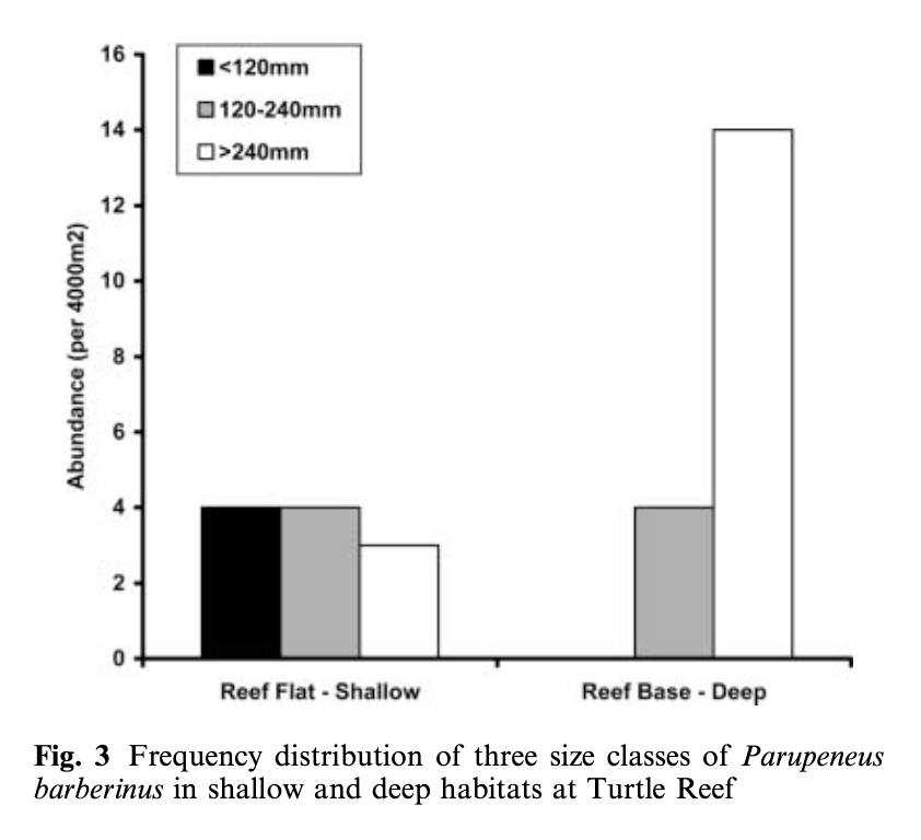
Lukoschek and McCormick’s (2001) study investigating the spatial distribution of a benthic fish species’ foraging behavior is a great example of combining data on behavior, habitat, and morphology.  They collected data on the diet composition of individual fish categorized into different size classes (small, medium, and large) and what foraging tactics were used in which reef zones and habitat types. The foraging tactics ranged from feeding in the water column to digging (at a range of depths) in the benthic substrate. The results showed that an interesting combination of fish behavior and morphology explained the observed diet composition and spatial distribution patterns. Small fish foraged in shallower water, on smaller prey, and primarily employed the water column and shallow digging tactics. In contrast, large fish foraged in deep water, on larger prey, and primarily fed by digging deeper into the seafloor (Figure 1). This pattern is explained by both morphology and behavior. Morphologically, the size of the feeding apparatus (mouth gape size) affects the size of the prey that a fish can feed on. The gape of the small fish is not large enough to eat the larger prey that large fish are able to consume. Behaviorally, predation risk also affects habitat selection and tactic use. Small fish are at higher risk of being predated on, so they remain in shallow areas where they are more protected from predators and they don’t dig as deep to forage because they need to be able to keep an eye out for predators. Interestingly, while they found a relationship between the morphology of the fish and habitat use, they did not find an association between specific feeding tactics and habitat types.

Figure 1. Figure from Lukoschek and McCormick (2001) showing that small fish (black bar) were found in shallow habitat while large fish (white bar) were found in deep habitat.

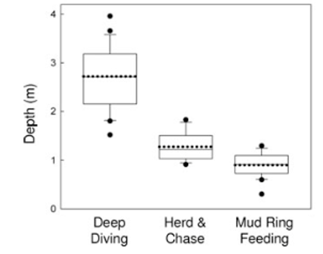
Conversely, Torres and Read (2009) did find associations between theforaging tactics of bottlenose dolphins in Florida Bay, FL and habitat type. Dolphins in this bay employ three foraging tactics: herd and chase, mud ring feeding, and deep diving. Observations of the foraging tactics were linked to habitat characteristics and individual dolphins. The study found that these tactics are spatially structured by depth (Figure 2), with deep diving occurring in deep water whereas mud ring feeding occurrs in shallower water. They also found evidence of individual specialization! Individuals that were observed deep diving were not observed mud ring feeding and vice-versa. Furthermore, they found that individuals were found in the habitat type associated with their preferred tactic regardless of whether they were foraging or not. This result indicates that individual dolphins in this bay have a foraging tactic they prefer and tend to stay in the corresponding habitat type. These findings are really intriguing and raise interesting questions regarding how these tactics and specializations are developed or learned. These are questions that I am also interested in asking as part of my thesis.

Figure 2. Figure from Torres and Read (2009) showing that deep diving is associated with deeper habitat while mud ring feeding is associated with shallow habitat.

Both of these studies are cool examples that, combined, exemplify questions I am interested in examining using our study population of Pacific Coast Feeding Group (PCFG) gray whales. Like both studies, I am interested in assessing how specific foraging tactics are associated with habitat types. Our hypothesis is that different prey types live in different habitat types, so each tactic corresponds to the best way to feed on that prey type in that habitat. While predation risk doesn’t have as much of an effect on foraging gray whales as it does on small benthic fish, I do wonder how disturbance from boats could similarly affect tactic preference and spatial distribution. I am also curious to see if depth has an effect on tactic choice by using the morphology data from our drone-based photogrammetry. Given that these whales forage in water that is sometimes as deep as they are long, it stands to reason that maneuverability would affect tactic use. As described in a previous blog, I’m also looking for evidence of individual specialization. It will be fascinating to see how foraging preference relates to space use, habitat preference, and morphology.

These studies demonstrate the complexity involved in studying a population’s relationship to its habitat. Such research involves considering the morphology and physiology of the animals, their social, individual, foraging, and predator-prey behaviors, and the relationship between their prey and the habitat. It’s a bit daunting but mostly really exciting because better understanding each puzzle piece improves our ability to estimate how these animals will react to changing environmental conditions.

While I don’t have any answers to these questions yet, I will be working with a National Science Foundation Research Experience for Undergraduates intern this summer to develop a habitat map of our study area that will be used in this analysis and potentially answer some preliminary questions about PCFG gray whale habitat use patterns. So, stay tuned to hear more about our work this summer!

References

Lukoschek, V., & McCormick, M. (2001). Ontogeny of diet changes in a tropical benthic carnivorous fish, Parupeneus barberinus (Mullidae): Relationship between foraging behaviour, habitat use, jaw size, and prey selection. Marine Biology, 138(6), 1099–1113. https://doi.org/10.1007/s002270000530

Torres, L. G., & Read, A. J. (2009). Where to catch a fish? The influence of foraging tactics on the ecology of bottlenose dolphins ( Tursiops truncatus ) in Florida Bay, Florida. Marine Mammal Science, 25(4), 797–815. https://doi.org/10.1111/j.1748-7692.2009.00297.x

Data Wrangling to Assess Data Availability: A Data Detective at Work

By Alexa Kownacki, Ph.D. Student, OSU Department of Fisheries and Wildlife, Geospatial Ecology of Marine Megafauna Lab

Data wrangling, in my own loose definition, is the necessary combination of both data selection and data collection. Wrangling your data requires accessing then assessing your data. Data collection is just what it sounds like: gathering all data points necessary for your project. Data selection is the process of cleaning and trimming data for final analyses; it is a whole new bag of worms that requires decision-making and critical thinking. During this process of data wrangling, I discovered there are two major avenues to obtain data: 1) you collect it, which frequently requires an exorbitant amount of time in the field, in the lab, and/or behind a computer, or 2) other people have already collected it, and through collaboration you put it to a good use (often a different use then its initial intent). The latter approach may result in the collection of so much data that you must decide which data should be included to answer your hypotheses. This process of data wrangling is the hurdle I am facing at this moment. I feel like I am a data detective.

Data wrangling illustrated by members of the R-programming community. (Image source: R-bloggers.com)

My project focuses on assessing the health conditions of the two ecotypes of bottlenose dolphins between the waters off of Ensenada, Baja California, Mexico to San Francisco, California, USA between 1981-2015. During the government shutdown, much of my data was inaccessible, seeing as it was in possession of my collaborators at federal agencies. However, now that the shutdown is over, my data is flowing in, and my questions are piling up. I can now begin to look at where these animals have been sighted over the past decades, which ecotypes have higher contaminant levels in their blubber, which animals have higher stress levels and if these are related to geospatial location, where animals are more susceptible to human disturbance, if sex plays a role in stress or contaminant load levels, which environmental variables influence stress levels and contaminant levels, and more!

Alexa, alongside collaborators, photographing transiting bottlenose dolphins along the coastline near Santa Barbara, CA in 2015 as part of the data collection process. (Image source: Nick Kellar).

Over the last two weeks, I was emailed three separate Excel spreadsheets representing three datasets, that contain partially overlapping data. If Microsoft Access is foreign to you, I would compare this dilemma to a very confusing exam question of “matching the word with the definition”, except with the words being in different languages from the definitions. If you have used Microsoft Access databases, you probably know the system of querying and matching data in different databases. Well, imagine trying to do this with Excel spreadsheets because the databases are not linked. Now you can see why I need to take a data management course and start using platforms other than Excel to manage my data.

A visual interpretation of trying to combine datasets being like matching the English definition to the Spanish translation. (Image source: Enchanted Learning)

In the first dataset, there are 6,136 sightings of Common bottlenose dolphins (Tursiops truncatus) documented in my study area. Some years have no sightings, some years have fewer than 100 sightings, and other years have over 500 sightings. In another dataset, there are 398 bottlenose dolphin biopsy samples collected between the years of 1992-2016 in a genetics database that can provide the sex of the animal. The final dataset contains records of 774 bottlenose dolphin biopsy samples collected between 1993-2018 that could be tested for hormone and/or contaminant levels. Some of these samples have identification numbers that can be matched to the other dataset. Within these cross-reference matches there are conflicting data in terms of amount of tissue remaining for analyses. Sorting these conflicts out will involve more digging from my end and additional communication with collaborators: data wrangling at its best. Circling back to what I mentioned in the beginning of this post, this data was collected by other people over decades and the collection methods were not standardized for my project. I benefit from years of data collection by other scientists and I am grateful for all of their hard work. However, now my hard work begins.

The cutest part of data wrangling: finding adorable images of bottlenose dolphins, photographed during a coastal survey. (Image source: Alexa Kownacki).

There is also a large amount of data that I downloaded from federally-maintained websites. For example, dolphin sighting data from research cruises are available for public access from the OBIS (Ocean Biogeographic Information System) Sea Map website. It boasts 5,927,551 records from 1,096 data sets containing information on 711 species with the help of 410 collaborators. This website is incredible as it allows you to search through different data criteria and then download the data in a variety of formats and contains an interactive map of the data. You can explore this at your leisure, but I want to point out the sheer amount of data. In my case, the OBIS Sea Map website is only one major platform that contains many sources of data that has already been collected, not specifically for me or my project, but will be utilized. As a follow-up to using data collected by other scientists, it is critical to give credit where credit is due. One of the benefits of using this website, is there is information about how to properly credit the collaborators when downloading data. See below for an example:

Example citation for a dataset (Dataset ID: 1201):

Lockhart, G.G., DiGiovanni Jr., R.A., DePerte, A.M. 2014. Virginia and Maryland Sea Turtle Research and Conservation Initiative Aerial Survey Sightings, May 2011 through July 2013. Downloaded from OBIS-SEAMAP (http://seamap.env.duke.edu/dataset/1201) on xxxx-xx-xx.

Citation for OBIS-SEAMAP:

Halpin, P.N., A.J. Read, E. Fujioka, B.D. Best, B. Donnelly, L.J. Hazen, C. Kot, K. Urian, E. LaBrecque, A. Dimatteo, J. Cleary, C. Good, L.B. Crowder, and K.D. Hyrenbach. 2009. OBIS-SEAMAP: The world data center for marine mammal, sea bird, and sea turtle distributions. Oceanography 22(2):104-115

Another federally-maintained data source that boasts more data than I can quantify is the well-known ERDDAP website. After a few Google searches, I finally discovered that the acronym stands for Environmental Research Division’s Data Access Program. Essentially, this the holy grail of environmental data for marine scientists. I have downloaded so much data from this website that Excel cannot open the csv files. Here is yet another reason why young scientists, like myself, need to transition out of using Excel and into data management systems that are developed to handle large-scale datasets. Everything from daily sea surface temperatures collected on every, one-degree of latitude and longitude line from 1981-2015 over my entire study site to Ekman transport levels taken every six hours on every longitudinal degree line over my study area. I will add some environmental variables in species distribution models to see which account for the largest amount of variability in my data. The next step in data selection begins with statistics. It is important to find if there are highly correlated environmental factors prior to modeling data. Learn more about fitting cetacean data to models here.

The ERDAPP website combined all of the average Sea Surface Temperatures collected daily from 1981-2018 over my study site into a graphical display of monthly composites. (Image Source: ERDDAP)

As you can imagine, this amount of data from many sources and collaborators is equal parts daunting and exhilarating. Before I even begin the process of determining the spatial and temporal spread of dolphin sightings data, I have to identify which data points have sex identified from either hormone levels or genetics, which data points have contaminants levels already quantified, which samples still have tissue available for additional testing, and so on. Once I have cleaned up the datasets, I will import the data into the R programming package. Then I can visualize my data in plots, charts, and graphs; this will help me identify outliers and potential challenges with my data, and, hopefully, start to see answers to my focal questions. Only then, can I dive into the deep and exciting waters of species distribution modeling and more advanced statistical analyses. This is data wrangling and I am the data detective.

What people may think a ‘data detective’ looks like, when, in reality, it is a person sitting at a computer. (Image source: Elder Research)

Like the well-known phrase, “With great power comes great responsibility”, I believe that with great data, comes great responsibility, because data is power. It is up to me as the scientist to decide which data is most powerful at answering my questions.

Data is information. Information is knowledge. Knowledge is power. (Image source: thedatachick.com)


The Land of Maps and Charts: Geospatial Ecology

By Alexa Kownacki, Ph.D. Student, OSU Department of Fisheries and Wildlife, Geospatial Ecology of Marine Megafauna Lab

I love maps. I love charts. As a random bit of trivia, there is a difference between a map and a chart. A map is a visual representation of land that may include details like topology, whereas a chart refers to nautical information such as water depth, shoreline, tides, and obstructions.

Map of San Diego, CA, USA. (Source: San Diego Metropolitan Transit System)

Chart of San Diego, CA, USA. (Source: NOAA)

I have an intense affinity for visually displaying information. As a child, my dad traveled constantly, from Barrow, Alaska to Istanbul, Turkey. Immediately upon his return, I would grab our standing globe from the dining room and our stack of atlases from the coffee table. I would sit at the kitchen table, enthralled at the stories of his travels. Yet, a story was only great when I could picture it for myself. (I should remind you, this was the early 1990s, GoogleMaps wasn’t a thing.) Our kitchen table transformed into a scene from Master and Commander—except, instead of nautical charts and compasses, we had an atlas the size of an overgrown toddler and salt and pepper shakers to pinpoint locations. I now had the world at my fingertips. My dad would show me the paths he took from our home to his various destinations and tell me about the topography, the demographics, the population, the terrain type—all attribute features that could be included in common-day geographic information systems (GIS).

Uncle Brian showing Alexa where they were on a map of Maui, Hawaii, USA. (Photo: Susan K. circa 1995)

As I got older, the kitchen table slowly began to resemble what I imagine the set from Master and Commander actually looked like; nautical charts, tide tables, and wind predictions were piled high and the salt and pepper shakers were replaced with pencil marks indicating potential routes for us to travel via sailboat. The two of us were in our element. Surrounded by visual and graphical representations of geographic and spatial information: maps. To put my map-attraction this in even more context, this is a scientist who grew up playing “Take-Off”, a board game that was “designed to teach geography” and involved flying your fleet of planes across a Mercator projection-style mapboard. Now, it’s no wonder that I’m a graduate student in a lab that focuses on the geospatial aspects of ecology.

A precocious 3-year-old Alexa, sitting with the airplane pilot asking him a long list of travel-related questions (and taking his captain’s hat). Photo: Susan K.

So why and how did geospatial ecology became a field—and a predominant one at that? It wasn’t that one day a lightbulb went off and a statistician decided to draw out the results. It was a progression, built upon for thousands of years. There are maps dating back to 2300 B.C. on Babylonian clay tablets (The British Museum), and yet, some of the maps we make today require highly sophisticated technology. Geospatial analysis is dynamic. It’s evolving. Today I’m using ArcGIS software to interpolate mass amounts of publicly-available sea surface temperature satellite data from 1981-2015, which I will overlay with a layer of bottlenose dolphin sightings during the same time period for comparison. Tomorrow, there might be a new version of software that allows me to animate these data. Heck, it might already exist and I’m not aware of it. This growth is the beauty of this field. Geospatial ecology is made for us cartophiles (map-lovers) who study the interdependency of biological systems where location and distance between things matters.

Alexa’s grandmother showing Alexa (a very young cartographer) how to color in the lines. Source: Susan K. circa 1994

In a broader context, geospatial ecology communicates our science to all of you. If I posted a bunch of statistical outputs in text or even table form, your eyes might glaze over…and so might mine. But, if I displayed that same underlying data and results on a beautiful map with color-coded symbology, a legend, a compass rose, and a scale bar, you might have this great “ah-ha!” moment. That is my goal. That is what geospatial ecology is to me. It’s a way to SHOW my science, rather than TELL it.

Would you like to see this over and over again…?

A VERY small glimpse into the enormous amount of data that went into this map. This screenshot gave me one point of temperature data for a single location for a single day…Source: Alexa K.

Or see this once…?

Map made in ArcGIS of Coastal common bottlenose dolphin sightings between 1981-1989 with a layer of average sea surface temperatures interpolated across those same years. A picture really is worth a thousand words…or at least a thousand data points…Source: Alexa K.

For many, maps are visually easy to interpret, allowing quick message communication. Yet, there are many different learning styles. From my personal story, I think it’s relatively obvious that I’m, at least partially, a visual learner. When I was in primary school, I would read the directions thoroughly, but only truly absorb the material once the teacher showed me an example. Set up an experiment? Sure, I’ll read the lab report, but I’m going to refer to the diagrams of the set-up constantly. To this day, I always ask for an example. Teach me a new game? Let’s play the first round and then I’ll pick it up. It’s how I learned to sail. My dad described every part of the sailboat in detail and all I heard was words. Then, my dad showed me how to sail, and it came naturally. It’s only as an adult that I know what “that blue line thingy” is called. Geospatial ecology is how I SEE my research. It makes sense to me. And, hopefully, it makes sense to some of you!

Alexa’s dad teaching her how to sail. (Source: Susan K. circa 2000)

Alexa’s first solo sailboat race in Coronado, San Diego, CA. Notice: Alexa’s dad pushing the bow off the dock and the look on Alexa’s face. (Source: Susan K. circa 2000)

Alexa mapping data using ArcGIS in the Oregon State University Library. (Source: Alexa K circa a few minutes prior to posting).

I strongly believe a meaningful career allows you to highlight your passions and personal strengths. For me, that means photography, all things nautical, the great outdoors, wildlife conservation, and maps/charts.  If I converted that into an equation, I think this is a likely result:

Photography + Nautical + Outdoors + Wildlife Conservation + Maps/Charts = Geospatial Ecology of Marine Megafauna

Or, better yet:

? + ⚓ + ? + ? + ? =  GEMM Lab

This lab was my solution all along. As part of my research on common bottlenose dolphins, I work on a small inflatable boat off the coast of California (nautical ✅, outdoors ✅), photograph their dorsal fin (photography ✅), and communicate my data using informative maps that will hopefully bring positive change to the marine environment (maps/charts ✅, wildlife conservation✅). Geospatial ecology allows me to participate in research that I deeply enjoy and hopefully, will make the world a little bit of a better place. Oh, and make maps.

Alexa in the field, putting all those years of sailing and chart-reading to use! (Source: Leila L.)


Can we talk about how cool sea otters are?

By Dominique Kone, Masters Student in Marine Resource Management

A couple of months ago, I wrote a blog introducing our new project, and my thesis, on the potential to reintroduce sea otters to the Oregon coast. In that blog, I expressed that in order to develop a successful reintroduction plan, scientists and managers need to have a sound understanding of sea otter ecology and the current state of Oregon’s coastal ecosystems. As a graduate student conducting a research-based thesis in a management program, I’m constantly fretting over the applicability of my research to inform decision-making processes. However, in the course of conducting my research, I sometimes forget just how COOL sea otters are. Therefore, in this blog, I wanted to take the opportunity to nerd out and provide you with my top five favorite facts about these otterly adorable creatures.

Photo Credit: Point Lobos Foundation

Without further ado, here are my top five favorite facts about sea otters:

  1. Sea otters eat a lot. Previous studies show that an individual sea otter eats up to 30% of its own body weight in food each day[1][2]. With such high caloric demands, sea otters spend a great deal of their time foraging the seafloor for a variety of prey species, and have been shown to decrease prey densities in their local habitat significantly. Sea otters are famously known for their taste for sea urchins. Yet, these voracious predators also consume clams, sea stars, crabs, and a variety of other small invertebrate species[3][4].

    Photo Credit: Katherine Johns via www.listal.com
  2. Individuals are specialists, but can change their diet. Sea otters typically show individual foraging specialization – which means an individual predominantly eats a select few species of prey. However, this doesn’t mean an otter can’t switch or consume other types of prey as needed. In fact, while individuals tend to be specialists, on a population or species level, sea otters are actually generalist predators[5][6]. Past studies that looked at the foraging habits of expanding sea otter populations show that as populations expand into unoccupied territory, they typically eat a limited number of prey. But as populations grow and become more established, the otters will start to diversify their diet, suggesting intra-specific competition[3][7].
  3. Sea otters exert a strong top-down force. Top-down forcing is one of the most important concepts we must acknowledge when discussing sea otter ecology. With top-down forcing, consumers at the top of the food chain depress the trophic level on which they feed, and this feeding indirectly increases the abundance of the next lower trophic level, resulting in a cascading effect[8]. The archetype example of this phenomenon is the relationship between sea otters, sea urchins, and kelp forests. This relationship goes as follows: sea otters consume sea urchin, and sea urchins graze on kelp. Therefore, sea otters reduce sea urchin densities by direct predation, thereby mediating grazing pressure on kelp. This indirect effect allows kelp to grow more abundantly, which is why we often see relatively productive kelp forests when sea otters are present[9]. This top-down forcing also has important implications for the whole ecosystem, as I’ll explain in my next fact.

    Pictured: sea urchin dominated seascape in habitat without sea otters. Photo Credit: BISHOPAPPS via Ohio State University.
  4. Sea otters help restore ecosystems, and associated ecosystem services. In kelp habitat where sea otters have been removed, we often see high densities of sea urchins and low biomasses of kelp. In this case, sea urchins have no natural predators to keep their populations in check and therefore completely decimate kelp forests. However, what we’ve learned is that when sea otters “reclaim” previously occupied habitats or expand into unoccupied territory, they can have remarkable restorative effects because their predation on sea urchins allows for the regrowth of kelp forest[10]. Additionally, with the restoration of key ecosystems like kelp forests, we can see a variety of other indirect benefits – such as increased biodiversity, refuge for fish nurseries and commercially-important species, and carbon sequestration[11][12][13]. The structure of nearshore ecosystems and communities change drastically with the addition or removal of sea otters, which is why they’re often referred to as keystone species.

    Photo Credit: University of California, Santa Barbara.
  5. Sea otters are most often associated with coastal kelp forests, but they can also exist in other types of habitats and ecosystems. In addition to kelp dominated ecosystems, sea otters are known to use estuaries and bays, seagrass beds, and swim over a range of bottom substrates[14][15]. As evidenced by previous studies, sea otters exert similar top-down forces in non-kelp ecosystems, as they do within kelp forests. One study found that sea otters also had restorative effects on seagrass beds within estuaries, where they consumed different types of prey (i.e., crabs instead of urchins), demonstrating that sea otters play a significant keystone role in seagrass habitats as well [12]. Findings such as these are vitally important to understanding (1) where sea otters are capable of living relative to habitat characteristics, and (2) how recovering or expanding sea otter populations may impact ecosystems and habitats in which they don’t currently exist, such as the Oregon coast.

Pictured: sea otter swimming through eel grass at Elkhorn Slough, California. Photo Credit: Kip Evans Photography.

Well, there you have it – my top five favorite facts about sea otters. This list is by no means exhaustive of all there is to know about sea otter ecology, and isn’t enough information to develop an informative reintroduction plan. However, a successful reintroduction plan will rely heavily on these underlying ecological characteristics of sea otters, in addition to the current state of Oregon’s nearshore ecosystems. As someone who constantly focuses on the relationship between scientific research and management and conservation, it’s nice every now and then to take a step back and just simply appreciate sea otters for being, well, sea otters.

References:

[1] Costa, D. P. 1978. The ecological energetics, water, and electrolyte balance of the California sea otter (Enhydra lutris). Ph.D. dissertation, University of California, Santa Cruz.

[2] Reidman, M. L. and J. A. Estes. 1990. The sea otter (Enhydra lutris): behavior, ecology, and natural history. United States Department of the Interior, Fish and Wildlife Service, Biological Report. 90: 1-126.

[3] Laidre, K.L. and R. J. Jameson. 2006. Foraging patterns and prey selection in an increasing and expanding sea otter population. Journal of Mammology. 87(4): 799-807.

[4] Estes, J. A., Jameson, R.J., and B. R. Rhode. 1982. Activity and prey election in the sea otter: influence of population status on community structure. The American Naturalist. 120(2): 242-258.

[5] Tinker, M. T., Costa, D. P., Estes, J. A., and N. Wieringa. 2007. Individual dietary specialization and dive behavior in the California sea otter: using archival time-depth data to detect alternative foraging strategies. Deep-Sea Research Part II. (54):330-342.

[6] Newsome et al. 2009. Using stable isotopes to investigate individual diet specialization in California sea otters (Enhydra lutris nereis). Ecology. 90(4): 961-974.

[7] Ostfeld, R. S. 1982. Foraging strategies and prey switching in the California sea otter. Oecologia. 53(2): 170-178.

[8] Paine, R. T. 1980. Food webs: linkage, interaction strength and community infrastructure. The Journal of Animal Ecology. 49(3): 666-685.

[9] Estes, J. A. and J.F. Palmisano. 1974. Sea otters: their role in structuring nearshore communities. Science. 185(4156): 1058-1060.

[10] Estes, J. A., and D. O. Duggins. 1995. Sea otters and kelp forests in Alaska: generality and variation in a community ecological paradigm. Ecological Monographs. 65(1): 75-100.

[11] Wilmers, C. C., Estes, J. A., Edwards, M., Laidre, K. L., and B. Konar. 2012. Do trophic cascades affect the storage and flux of atmospheric carbon? An analysis of sea otters and kelp forests. Frontiers in Ecology and the Environment. 10(8): 409-415.

[12] Hughes et al. 2014. Recovery of a top predator mediate negative eutrophic effects on seagrass. Proceedings of the National Academy of Sciences. 110(38): 15313-15318.

[13] Lee, L.C., Watson, J. C., Trebilco, R., and A. K. Salomon. Indirect effects and prey behavior mediate interactions between an endangered prey and recovering predator. Ecosphere. 7(12).

[14] Laidre, K. L., Jameson, R. J., Gurarie, E., Jeffries, S. J., and H. Allen. 2009. Spatial habitat use patterns of sea otters in coastal Washington. Journal of Mammalogy. 90(4): 906-917.

[15] Lafferty, K. D., and M. T. Tinker. 2014. Sea otters are recolonizing southern California in fits and starts. Ecosphere. 5(5).


Making a Splash

By: Cathryn Wood, Lawrence University ’17, summer REU in the GEMM Lab

Greetings from Port Orford! My name is Cathryn, and I am the fourth member of the GEMM Lab’s gray whale foraging ecology research team, which includes Florence, Kelli, and the other Catherine (don’t worry, I go by Cat). Nearly 5 weeks into field season, I am still completely amazed with my first West Coast experience and doing what I’ve always dreamt of: studying marine mammals. Coming from Michigan’s Upper Peninsula, this may seem slightly out of place, but my mom can attest; she read “Baby Beluga” to me every night when I was a toddler. Now a rising senior majoring in biology at Lawrence University, I’ve been focusing my coursework on aquatic and marine ecology to prepare for graduate school where I plan to specialize in marine science. Being part of this research is a very significant step for me into the field.

So how did I end up here, as part of this amazing project and dream, women-in-science team? I am interning through OSU’s Ocean Sciences REU program at the Hatfield Marine Science Center, where the GEMM Lab is located. REU stands for “Research Experience for Undergraduates ”, and is an NSF-funded research internship program found in numerous universities around the country. These internships allow undergrads to conduct independent research projects under the guidance of a faculty mentor at the program’s institution. I applied to several REUs this past winter, and was one of 12 undergrads accepted for the program at HMSC. Each of us is paired with different faculty members to work on various projects that cover a diverse range of topics in the marine sciences; everything from estuarine ecology, to bioacoustics. I was ecstatic to learn that I had been paired with Dr. Torres as my faculty mentor to work on Florence’s gray whale project, which had been my first choice during the application process.

My particular research this summer is going to complement Florence’s master’s thesis work by asking new questions regarding the foraging data. While her project focuses on the behavioral states of foraging whales, I will be looking at the whale tracks to see if there are patterns in their foraging behavior found at the individual level. Traditionally, ecological studies have accepted classical niche theory, treating all individuals within a population as ecological equivalents with the same niche width. Any variances present among individuals are often disregarded as having an insignificant consequence on the population dynamics as a whole, but this simplification can overlook the true complexity of that population . The presence of niche variation among conspecifics is known to occur in at least 93 species across a diverse array of taxa, so the concept of individual specialization, and how it can affect ecological processes is gaining recognition progressively in the field (Bolnick et al., 2003). My goal is to determine whether or not the gray whales in this study, and presumably others in the Pacific Coast Feeding Group (PCFG), exhibit individual specialization in their foraging strategies . There are many ways in which individuals can specialize in foraging, but I will be specifically determining if fine scale spatial patterns in the location of foraging bouts exists, regardless of time.

To address my question, I am using the whale tracking data from both 2015 and 2016, and learning to use some very important software in the spatial ecology world along the way through a method that Dr. Torres introduced to me. Starting in ArcGIS, I generate a kernel density layer of a raw track (Fig. 1 ), which describes the relative distribution of where the tracked whale spent time (Fig. 2 ). Next, using the isopleth function in the software Geospatial Modelling Environment, I generate a 50% density contour line that distinguishes where the whale spent at least 50% of its time during the track (Fig. 3 ). Under the assumption that foraging took place in these high density areas, we use these 50% contour lines to describe foraging bout locations. I now go back to ArcGIS to make centroids within each 50% line, which mark the exact foraging bout locations (Fig. 4 ).

Fig.1 Raw individual whale track.
Fig. 1 Raw individual whale track.

Fig. 2 Kernel Density map of whale track.

Fig. 3 50% isopleth contours of locations with highest foraging densities

Fig. 4 Final centroids to signify foraging bouts

These centroids will be determined for every track by an individual whale, and then compared relative to foraging locations of all tracked whales to determine if the individual is foraging in different locations than the population. Then, the tracks of individuals who repeatedly visit the site at least three times will be compared with one another to determine if the repeat whales show spatial and/or temporal patterns in their foraging bout locations, and if specialization at a fine scale is occurring in this population. If you did not quite follow all those methods, no worries, it was a lot for me to take in at first too. I’ve finally gotten the hang of it though, and am grateful to now have these skills going into grad school.

Because I am interested in behavioral ecology and the concept of individuality in animal populations, I am extremely excited to see how this research plays out. Results could be very eye-opening into the fine scale foraging specialization of the PCFG sub-population because they already demonstrate diet specialization on mysid (as opposed to their counterparts in the Bering Sea who feed on benthic organisms) and large scale individual residency patterns along the Pacific Northwest (Newell, 2009; Calambokidis et al., 2012). Most significantly, understanding how individuals vary in their feeding strategies could have very important implications for future conservation measures for the whales, especially during this crucial foraging season where they replenish their energy reserves.  Management efforts geared for an “average population” of gray whales could ultimately be ineffective if in fact individuals vary from one another in their foraging strategies. Taking into account the ways in which variation occurs amongst individuals is therefore crucial knowledge for successful conservation approaches.

My project is unique from those of the other REUs because I am simultaneously in the midst of assisting in field season number two of Florence’s project. While most of the other interns are back at Hatfield spending their days in the lab and doing data analyses like a 9-5 job, I am with the team down in Port Orford for field season. This means we’re out doing research every dawn as weather allows. Though I may never have an early bird bone in my body, the sleepy mornings are totally worth it because ecology field work is my favorite part of research. To read more about our methods in the field, check out Florence’s post.

Since Catherine’s last update, we’ve had an eventful week. To our dismay, Downrigger Debacle 2.0 occurred. (To read about the first one, see Kelli’s post). This time it was not the line – our new line has been great. It was a little wire that connected the downrigger line to the pipe that the GoPro and TDR are connected to. It somehow snapped due to what I presume was stress from the currents.   Again, it was Catherine and I in the kayak, with a very successful morning on the water coming to a close when it happened. Again, I was in the bow, and she was in the stern deploying the equipment – very déjà vu. When she reeled in an equipment-less line, we at first didn’t know how to break it to Florence and Kelli who were up on the cliff that day. Eventually, Catherine radioed “Brace yourselves…” and we told them the bad news. Once again, they both were very level-headed, methodical, and un-blaming in the moments to follow. We put together the same rescue dive team as last time, and less than a week later, they set off on the mission using the GPS coordinates I had marked while in the kayak. Apparently, between the dredging taking place in the harbor and the phytoplankton bloom, visibility was only about 2 feet during the dive, but they still recovered the equipment, with nothing but baked goods and profuse thanks as payment. We are very grateful for another successful recovery, and are confident that our new attachment mechanism for the downrigger will not require a third rescue mission (Fig. 6-8). Losing the equipment twice now has taught us some very important things about field work. For one, no matter how sound you assume your equipment to be, it is necessary to inspect it for weak points frequently – especially when salt water and currents are in the picture. Perhaps even more importantly, we’ve gotten to practice our problem solving skills and see firsthand how necessary it is to act efficiently and calmly when something goes wrong. In ecological field research you have to be prepared for  anything.

Fig. 5 Original setup of GoPro and TDR.

Fig. 6 Photo taken after the wire that connected the pole to the downrigger line snapped.

Fig. 7 New mechanism for attaching the pole to the downrigger line.

Fig. 8 Equipment rescue team: Aaron Galloway and Taylor Eaton diving, Greg Ryder operating the boat, and Florence on board to direct the GPS location of where the equipment was lost.

In other news, unlike our slow-whale days during the first two weeks of the project, we have recently had whales to track nearly every day from the cliff! In fact, the same, small, most likely juvenile, whale pictured in Catherine’s last post has returned several times, and we’ve nicknamed her “Buttons” due to two distinguishing white spots on her tail peduncle near the fluke. Though we tend to refer to Buttons as “her”, we cannot actually tell what the sex is definitively…until now. Remember in Catherine’s post when she described how Buttons defecated a lot, and how our team if, given the opportunity, is supposed to collect the feces when we’re out in the kayak for Leila’s project?  Everything from hormone levels to reproductive status to, yes, sex, is held in that poop! Well, Miss (or Mr.) Buttons was in Tichenor Cove today, and to our delight, she performed well in the defecation department once again. Florence and I were on cliff duty tracking her and Kelli and Catherine were in Tichenor on the kayak when we first noticed the defecation.  I then radioed down to the kayak team to stop what they were doing and paddle quickly to go collect it before it sank (Fig. 9).  Even in these situations, it is important to stay beyond 100 yards of the animal, as required by the MMPA. Florence and I cheered them on and our ladies did indeed get the poop sample, without disturbing the whale (Fig. 10). It was a sight to behold.

Fig. 9 Kelli and Catherine on a mission.

Fig. 10 Kelli and Catherine collecting the feces.

We were able to track Buttons for the remainder of our time on the cliff, and were extremely content with the day’s work as we packed all the gear up later in the afternoon. Right before we were about to leave, however, Buttons had one more big treat for us. As we looked to the harbor before starting the trek back to the truck, we paused briefly after noticing a large, white splash in the middle of the harbor, not far from the dock. We paused for a second and thought “No, it can’t be, was that —?” and then we see it again and unanimously yelled “BREACH!” Buttons breached about five times on her way back to Tichenor Cove from where she had been foraging in Mill Rocks. It is rare to see a gray whale breach, so this was really special. Florence managed to capture one of the breaches on video:

At first I thought a big ole humpback had arrived, but nope, it was our Buttons! I am in awe of this little whale, and am forever-grateful to be in the presence of these kinds of moments. She’s definitely made her splash here in Port Orford. I think our team has started to as well.


Bolnick, D. I., Svanback, R., Fordyce, J. A., Yang, L. H., Davis, J. M., Hulsey, C. D., & Forrister, M. L. (2003). Ecology of Individuals: Incidence and Implications of Individual Specialization. The American Naturalist, 161(1), 28.

Calambokidis, J., Laake, J. L., & Klimek, A. (2012). Updated analysis of abundance and population structure of seasonal gray whales in the Pacific Northwest, 1998-2010 (Vol. 2010).

Newell, C. (2009). Ecological Interrelationships Between Summer Resident Gray Whales (Eschrichtius robustus) and Their Prey, Mysid Shrimp (Holmesimysis sculpta and Neomysis rayi) along the Central Oregon Coast.