A Tsunami on the Columbia

What might happen if a nearshore tsunami caused by a local earthquake were to travel from the Oregon coast up the Columbia River? That was the focus of a recent research workshop funded by Oregon Sea Grant at Oregon State University (OSU), August 15-16.

“We know tsunamis can penetrate along rivers for long distances,” said OSU tsunami expert Harry Yeh, the workshop organizer. But, said Yeh, tsunami penetration up rivers has been largely unexplored until now.

“In the coastal plain they [tsunamis] can penetrate 2 to 5 kilometers [about 1 to 3 miles], but with the river they can penetrate up to 10 kilometers [about 6 miles] no problem.”

The Oregon Coast lies along the Cascadia subduction zone, a fault line that stretches from Northern California to British Columbia. The Cascadia subduction zone is similar to the subduction zone that caused Japan’s recent earthquake and tsunami. A magnitude 9.0 earthquake occurs along the Cascadia subduction zone once every 300-500 years. It had its most recent earthquake in 1700. This expected earthquake would most likely be accompanied by a tsunami, which could affect the Columbia River, said Yeh.

The 18 workshop attendees were asked by Yeh to model a section of the Columbia that stretches from Astoria, Oregon at the coast all the way to the Bonneville Dam. Yeh said the idea was to gather general data that could be used in future tsunami modeling.

“We are not trying to do detailed models of say Astoria or Longview, for instance,” said Yeh.  “Though, I think that’s next step.”

Many of Oregon’s coastal communities could one day feel the affects of a tsunami. Communities that could be flooded or inundated by tsunamis have been mapped by the Oregon Department of Geology and Mineral Industries into inundation zones. But these inundation maps don’t include the Columbia, said Yeh. Instead the maps stop at Astoria, which lies at the mouth of the Columbia. The workshop’s exploration of what might happen if a Tsunami penetrated the Columbia could change how tsunami inundation maps are made in the future, said Yeh.

“This work is very theoretical, very academic, but it has direct consequences and real applications, which is why I feel like this is important work,” said Yeh.

Events at the recent workshop included presentations by Yinglong Joseph Zhang of Oregon Health and Science University on how far a tsunami could penetrate the Columbia, as well as a presentation by David Jay of Portland State University, on the hydrodynamics of the river. Workshop discussions also included comparing different tsunami modeling techniques including those used by the National Oceanic and Atmospheric Administration (NOAA) and those used by the Japanese government.

Of particular interest to Yeh himself is a stretch of the Columbia that starts at Astoria and follows the Columbia until it turns south toward Portland at Longview, Oregon. Yeh says the bathmetry, or depth of the water in this area is very complex and includes marshes, and islands and other complex topography, which makes modeling complex. The islands, marshes, and other elements of the river’s landscape will play into what is known as the friction effect, which Yeh lead a discussion on during the workshop.

Yeh’s workshop also examined the affect the movement of the tide could have on a tsunami traveling from the Pacific Ocean to the Columbia River. Whether the tide is coming in or out could be very important, said Yeh.

Of particular interest to researchers at the workshop was whether a tsunami could reach Portland, Oregon.

“Even in the Portland area residents could feel the affects of a tsunami,” said Yeh. “Although this affect is going to be very small, it is going to be measurable.”

Yeh recently returned from Japan where he witnessed the results of the earthquake and tsunami that devastated the country, including how the recent tsunami traveled up the Kitakami River.

Yeh, who started studying tsunamis in 1985, saw the results of a tsunami first hand in 1992 after a large tsunami hit Nicaragua. His past research has included Oregon Sea Grant funded work with fellow OSU Professor Daniel Cox. In 2009, Cox created a model of the coastal Oregon city of Seaside that he, with the help of Yeh, then inundated with a simulated tsunami using the university’s O.H Hinsdale Wave Research Laboratory, a facility that contains a wave machine capable of creating scaled facsimiles of tsunamis. The model town received a scaled-down version of a tsunami that could hit Seaside if the Cascadia subduction zone experiences a 9.0 magnitude earthquake.

Yeh said the workshop went well and has resulted in a further collaboration between himself and several workshop attendees.


Oregon Sea Grant publishes book about sustaining salmon ecosystems

The following publication may be purchased from Oregon Sea Grant.

Pathways to Resilience: Sustaining Salmon Ecosystems in a Changing World.

“Resilience holds the key to our future. It is a deceptively simple idea, but its application has proven elusive.”
—Jane Lubchenco, administrator of NOAA

Fishery management programs designed to control Pacific salmon for optimum production have failed to prevent widespread fish population decline and have caused greater uncertainty for salmon, their ecosystems, and the people who depend upon them. Strengthening salmon resilience will require expanding habitat opportunities for salmon populations to express their maximum life-history variation. Such actions also may benefit  human communities by expanding the opportunities for people to express diverse social and economic values.

The 11 essays in this book represent the most-forward thinking about resilience and Pacific salmon collected to date, and they point to new ways we may consider and interact with this iconic fish. It should be of interest not only to those active in fisheries but also to policymakers—and, by extension, to those interested in the resilience of other ecological and social systems.

By linking theory with practice, the authors of this volume have made a quantum leap forward in understanding how to manage critical populations. A must read for resilience scholars and practitioners.
—Lance Gunderson, Professor of Environmental Studies, Emory University

All too often, our attempts at conservation fail because we think too small. We fail to see connections, the broader context, and longer-term processes. The authors of this volume think big. Pathways to Resilience is just what we need for animals that migrate thousands of miles and cross ecosystem and political boundaries at will. This is worth reading and taking good notes.
—Jack E. Williams, Senior Scientist, Trout Unlimited

Educators gather for ocean literacy symposium

NEWPORT  – Oregon Sea Grant and the OSU Hatfield Marine Science Center join the Lincoln County School District and the Oregon Coast Aquarium this Tuesday to host Lincoln County’s first K-12 Ocean Literacy Symposium.

Sessions will take place at Newport High School, Sea Grant’s HMSC Visitor Center, and the nearby Aquarium.

The program, part of a district-wide in-service day for licensed teachers and administrators, is aimed at boosting  students’ ocean literacy by providing Lincoln County teachers and their classes with better access to the knowledge and experience of the many ocean and coastal agencies and programs located in Newport.

The symposium is a district-wide in-service day for all licensed teachers and administrators. Participants will learn new strategies and resources for teaching marine science in the classroom to help students meet state standards. Teachers will explore the mud flats and learn new ways to engage students in math and science. They will also learn how to use songs to increase students’ understanding of complex topics and a variety of other teaching techniques.

“It’s really exciting to have a day where teachers, administrators, scientists and informal educators can get together to develop strategies for connecting our local students to the ocean,” said Rachael Bashor, OCA school liaison/partnership coordinator. “We are lucky to live in a county where our district is committed to taking advantage of the unique learning opportunities available in our rural coastal communities.”

Craig Strang, associate director of the Lawrence Hall of Science, University of California, Berkeley, will start the day with a keynote address at Newport High School. Immediately following, nearly 50 presentations from local teachers and agencies will be offered in break-out sessions at the OCA and HMSC.

New on DVD! Cascade Head / Scenic Research Area

Cascade HeadGrab your hiking boots and binoculars! This video will take you on a scenic and historical walk through the beautiful prairie headlands, forests, and grassy marshes of Cascade Head and the adjoining Salmon River estuary.

Ever heard of Pixieland? Kami Ellingson, from the Siuslaw National Forest, will take us on a guided tour of the complex history of commercial and residential developments that once threatened to pave paradise.

Stay on the trails, because that little blue violet up on the headlands feeds the Oregon silverspot caterpillar, one of four threatened or endangered animal species that live here. The Nature Conservancy’s Debbie Pickering tells us the butterfly’s story.

Back in the marshes, NOAA Fisheries scientist Dan Bottom describes the history of a massive habitat-restoration project, in which dikes were removed from the estuary in the hope of improving salmon runs. Western Oregon University Professor Karen Haberman shares her Sea-Grant sponsored research in the marsh–an unusual focus area with surprising consequences.

And finally, Eric Vines gives us a tour of the Sitka Center for Art and Ecology, one of the many recreational opportunities at Cascade Head.

The full program is available on DVD from the Oregon State University Marketplace

Exclusive: Watch a short featurette not included on this DVD: Salmon River Marsh / Undergraduate Field Experiences (about 2 mins)


NOAA and community dedicate new Marine Operations Center

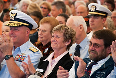
Ginny Goblirsch, retired Oregon Sea Grant Extension agent and Newport Port Commissioner, applauds a dedication speakerNEWPORT – From federal dignitaries to small children – with lots of uniformed NOAA Corps officers, local fishermen and shop keepers, retirees, scientists, Oregon State University administrators and construction workers thrown in – Newport turned out under dazzling blue skies today to formally dedicate the National Oceanic and Atmospheric Administration’s new Marine Operations Center – Pacific.

About the only ones who didn’t make it to the party were the research and survey vessels that will call the new facility home. It’s the height of the research season for them, and they and their crews are out at sea.

When they return to port, they’ll find a $38 million, state-of-the art facility with everything needed to support and maintain NOAA’s high-tech Pacific research vessels – and a community that seems absolutely thrilled to have them here for at least the next 20 years. If the “Welcome NOAA” signs that have popped up all over town during the past two years weren’t enough proof of that, the enthusiastic crowd was.

The formal dedication took place in a tent big enough to seat 560 people. Every chair appeared to be filled, and the overflow stood outside in the sunshine and listened as speakers – from Port of Newport General Manager Don Mann to US Congressmen, Oregon’s governor and NOAA Administrator Jane Lubchenco (herself an Oregonian) praised the community for its unified support of the project, the contractors and engineers for bringing it in on time, under budget and with a stellar safety record, and NOAA for bringing jobs and economic development that will bolster the community’s already strong reputation as a center for marine research.

Then it was back outside, where those who’d spoken pulled the ropes to unfurl a banner labeling the facility’s headquarters building – almost. One corner got stuck, despite Dr. Lubchenco’s best effort to yank it free, and finally had to be freed by a NOAA Corps officer who went inside, opened a window and freed the stuck corner, to applause from the crowd.

The rest of the afternoon was devoted to tours of the facility, its small museum of precious NOAA artifacts, exhibits by NOAA’s component organizations (the National Weather Service, NOAA Fisheries, etc.), and strolling out onto the huge new docks and enjoying the sunshine. Dr. Lubchenco boarded a crabbing boat, the Delma Ann, for a quick trip over to the Port of Newport, where she was briefed on the success of a lost-gear retrieval project funded by a $790,000 NOAA grant. (An Oregon Sea Grant pilot project in 2007 helped pave the way for that effort.)

The weekend celebration continues on Sunday, with an open house from 11 am to 4 pm. It’s a rare opportunity for the public to see the facility, which will be closed to the public except for special occasions and organized tours.


Scientists accurately predict undersea eruption

NEWPORT, Ore. – The undersea geology world is buzzing about the recent discovery that the Axial Seamount – an undersea volcano about 250 miles off the Oregon coast – has erupted. But what has everyone excited is that the eruption had been forecast by a team of scientists who’ve been monitoring the mount for years.

It’s being called the first-ever successful forecast of an undersea volcano.

Bill Chadwick, an Oregon State University geologist based at the Hatfield Marine Science Center, and Scott Nooner, of Columbia University, have been monitoring Axial Seamount for more than a decade, and in 2006 published a paper in the Journal of Volcanology and Geothermal Research in which they forecast that Axial would erupt before the year 2014. Their forecast was based on a series of seafloor pressure measurements that indicated the volcano was inflating.

“Volcanoes are notoriously difficult to forecast and much less is known about undersea volcanoes than those on land, so the ability to monitor Axial Seamount, and determine that it was on a path toward an impending eruption is pretty exciting,” said Chadwick, who was chief scientist on the recent expedition, which was jointly funded by the National Oceanic and Atmospheric Administration and the National Science Foundation.

Axial last erupted in 1998 and Chadwick, Nooner and colleagues have monitored it ever since. They used precise bottom pressure sensors – the same instruments used to detect tsunamis in the deep ocean – to measure vertical movements of the floor of the caldera much like scientists would use GPS on land to measure movements of the ground. They discovered that the volcano was gradually inflating at the rate of 15 centimeters (six inches) a year, indicating that magma was rising and accumulating under the volcano summit.

When Axial erupted in 1998, the floor of the caldera suddenly subsided or deflated by 3.2 meters (10.5 feet) as magma was removed from underground to erupt at the surface. The scientists estimated that the volcano would be ready to erupt again when re-inflation pushed the caldera floor back up to its 1998 level.

“Forecasting the eruption of most land volcanoes is normally very difficult at best and the behavior of most is complex and variable,” said Nooner, who is affiliated with the Lamont-Doherty Earth Observatory. “We now have evidence, however, that Axial Seamount behaves in a more predictable way than many other volcanoes – likely due to its robust magma supply coupled with its thin crust, and its location on a mid-ocean ridge spreading center.

“It is now the only volcano on the seafloor whose surface deformation has been continuously monitored throughout an entire eruption cycle,” Nooner added.

Read more from:

Hatfield legacy lives in OSU leadership in marine sciences

Hatfield-DedicationNEWPORT, Ore. – The passing Sunday of former U.S. Senator and Oregon Governor Mark Hatfield prompted an outpouring of remembrances of the political legend and his contributions to the state, including Newport, where Oregon State University’s Hatfield Marine Science Center bears his name.

Hatfield was supportive of the development of the center, which officially opened in June 1965 during his second term as Oregon governor. During his five terms as a U.S. senator, Hatfield steered critical federal funding to Newport for buildings and programs. In 1983, the center was officially named the Mark O. Hatfield Marine Science Center (HMSC).

Today, more than 300 scientists and staff members work at HMSC’s 49-acre campus. In addition to faculty researchers and students from OSU and visiting researchers from other academic institutions, the campus is home to representatives of the U.S. Fish and Wildlife Service, the U.S. Environmental Protection Agency, the U.S. Department of Agriculture, the National Oceanic and Atmospheric Administration and the Northwest National Marine Renewable Energy Center, as well as the Oregon Department of Fish and Wildlife. It is also home port for the OSU research vessels Wecoma and Elakha.

In addition to its research labs, the facility is home to the HMSC Visitor Center, managed by Oregon Sea Grant as a public aquarium, marine education center and living laboratory for the study of free-choice learning.

“The Hatfield Marine Science Center is a living legacy, one that will serve Oregon, Oregonians, our nation and our world for generations to come,” OSU President Edward J. Ray. “I can think of no finer tribute to Mark Hatfield’s lifetime of public service.”

(Read more from OSU  News & Research Comunication)